Pacific Crest Trail, 1978. ~Jim Gradziel.
Copyright James Gradziel, 2003
This is a record of a solo foot journey undertaken by Jim Gradziel in the year 1978 following the Pacific Crest Trail from its beginning at the Mexican border just outside of Campo, California, to its end at the Canadian border in Manning Provincial Park, in British Columbia, Canada. The journey started on May 5 and was completed on October 5, some 4.5 million footsteps later.


The Trail
The Pacific Crest Trail stretches roughly 2,400 miles from the US/Mexican Border in the California town of Campo to Monument 78, a concrete monolith marking the US/Canadian border in Washington state. The trail extends through the states of California, Oregon, and Washington, mainly along the crest of the mountain ranges of those states. The route traverses lands rich in natural resources and beauty that vary from the dry California desert to the verdant North Cascades, and from the High Sierra to the deep Columbia River Gorge. The route passes through 23 National Forests and seven National Parks. The trail incorporates the John Muir Trail in the Sierra Nevadas, the Oregon Skyline Trail and the Cascade Crest trail in Washington.
The Gear
Everything I needed to survive I carried on my back. My shelter, my bed, my kitchen and my wardrobe, all selected for weight and utility, fit neatly into my backpack. My shelter was a 2 man backpacker tent from Sierra Designs, my bed a down sleeping bag from LL Bean and an ensolite pad to isolate me from the cold hard ground. My kitchen gear included a SVEA 123 backpacker stove, which burned white gas as well as unleaded auto gas; a Sierra Cup, a mess kit, two 1/2 liter fuel bottles, two water bottles, and a collapsible 1 1/2 gallon water jug. My wardrobe included a rain poncho, hat for shielding from the desert sun, shorts, pants, shirts, jacket, and a pair of down booties. I also carried a 35 mm camera, zoom lens, and tripod. Along the way, I purchased a telescoping fishing rod. Miscellaneous items included a first aid kit, small radio, maps and guidebooks and a journal. My backpack was a Kelty Tioga; a pack that had served me well in hiking the Appalacian Trail. I typically carried food for 7 to 10 days. I usually resupplied at stores along the route, though I did arrange for mailed food drops in a few isolated sections. My menu included oatmeal and cocoa for breakfasts, bread, peanut butter and jam for lunches, and dry soup, instant rice, instant potatoes, macaroni, cheese, and dried meats for dinners. I regularly made instant puddings for desert and Jello, which set overnight and was eaten first thing in the morning. I wore a pair of heavy duty backpacking boots and took care to pay attention to my feet at the end of every day.


The Hike
The spring of 1978 brought an abundance of sunshine and wildflowers to southern California. The first part of the trail followed a temporary route along paved and dirt roads and the route was not clearly marked. The maps I was carrying were not particularly detailed and I navigated by dead reckoning. I managed to get lost several times but always managed to find myself again. I got into snow the first time at Mt San Jacinto, but was back into dry semi-desert the next day. The route followed a washed out Whitewater River to its source on the northern slope of the San Gorgonio Mountains.

The hot springs at Deep Creek Canyon offered a refreshing soak followed by immersion in ice-cold Deep Creek. A troop of Boy Scouts hosted me among the beautiful wildflowers at Cajon Pass just east of Los Angeles. A week later I began to cross the Mojave Desert , packing two gallons of water and hiking at night. Unfortunately, in the daytime, my water heated to the air temperature of 100 degrees F. and was not very refreshing. The route shortly began to follow the buried Los Angeles Aqueduct and I managed to figure out a way to "borrow" some of that cool mountain water.
On June 3, I reached the beginnings of the High Sierras and had to change plans because of deep snow and high water in the mountains. I temporarily bypassed the Sierras and rejoined the Pacific Crest Trail at Belden , in northern California. The northern California terrain was quite different from that of the south and, though I was intermittently back in snow, the hiking was very enjoyable. I was invited to lunch at the Stump Ranch by Barbara Frost and was the first hiker of the year to sign her logbook.

The route led toward Mt Shasta, and I spent a day of R&R in Castle Craigs State Park near Castella. The mountain lakes were just starting to get free of ice and the fish were ravenous (but so was I!). On June 27, I crossed the state line into Oregon and was greeted with my first real rain of the trip. I stopped for a day in Ashland, Oregon, home to a Shakespeare Company, and watched half of "Richard III" before the production got rained out.
The fourth of July found me at Crater Lake, and shortly thereafter I was introduced to the scourge of the Northwest Woods. The trail took me by the Three Sisters , some of the most spectacular mountain peaks I'd yet seen. The gorgeous days of hiking through this wilderness area were followed by several days of rain and low clouds that totally obstructed the view. Finally the weather cleared as I was approaching Mt Jefferson, and for the next several days I walked among the huckleberry bushes and forested trail to the base of Mt Hood. Finally, on July 22, I descended from the ridge top to the Columbia River Gorge, and the town of Cascade Locks.
The next seven days were spent back in civilization, hitch-hiking, visiting friends, and bus riding through sweltering summer days as I made my way back to the trail in southern California, from where I had skipped north nearly two months previous. On July 29, I rode a Greyhound into the town of Bakersfield and then hitched a ride to Weldon, California, at the foot of the High Sierras. The snow and flood that blocked the path in June was largely gone. I packed provisions for 18 days and set off down the dusty desert trail for the snow-covered highlands.

The trail into and through the High Sierras was very different from the lush, forested path I had left in Oregon. The trail was mostly open, winding around boulders, across streams, and over mountain passes. There was little shelter from the hot sun and afternoon thunderstorms were common. I stashed my gear trailside and took a day trip to the top of Mt Whitney, at 14,494 ft, the highest mountain in the lower forty-eight. The peak was snow free, but kind of crowded. There was a stone shelter at the top, which, being sheltered from the sun was still full of snow.
I finally managed to catch some fish for dinner at Twin Lakes. I'm sure the fish were stocked, as the lake was small and high enough in elevation to freeze solid in the winter. By August 16 I was in Lyell Canyon, at the edge of Yosemite Park. The park was very popular with hikers and even more popular with the bears that have become quite skilled at retrieving stashed food. This was the site of my one and only hostile bear encounter of the trip. As I left Yosemite, the wind picked up and the people thinned out. The trail wound across the ridge tops through an abundance of wildflowers and the weather started getting colder with frost in the mornings.
My future wife Susan and sister Peg met me at Echo Lake and we hiked for a day together into Desolation Wilderness and camped on the shore of Aloha Lake. The next day I left Susan and Peg behind and continued on toward Canada. As I left the Sierras, I was once more hiking on temporary trail and roadways. I took a side trail to the fire tower at the top of the Sierra Buttes. I had seen a picture of the tower in the National Geographic and was determined to visit it.
A pair of Spotted Owls visited me in camp the night before I reached Belden, CA, the town I had skipped north to back in June when the Sierras were impassible. Susan met me at Belden and we drove north through rainy weather back to the Oregon/Washington state line where I had interrupted my hike to do the Sierras. The storm that rained on us dropped six feet of snow on the Sierras.

I paid a 25-cent pedestrian toll and crossed the Bridge of the Gods over the Columbia River and into Washington. I hiked through rain for several days before finally getting some dry sunny weather. The trail was now lined with oceans of huckleberries while Mt Adams, Mt Rainier, and Mt St Helens loomed on the horizon with new coats of snow.
I met Susan at White Pass and we hiked together for a couple days. The weather was getting more winter-like and for the first time on the trip, it snowed. We hiked through a couple inches of snow to Chinook Pass, where Susan returned to civilization and I returned to solo hiking. Warm sunshine melted the snow on the south side of the ridges while snowdrifts covered the north side. A few days of warm rain finally melted the last of the snow before I entered the Alpine Lakes Wilderness.
Rain and sunshine alternated as I approached Glacier Peak in northern Washington. I hiked around the peak in rain and drizzle and finally got some good views looking back from the north. I stayed in a trailside cabin just below Suiattle Pass alongside the remains of a maintenance crew camp. The last town near the trail before Canada is Stehekin, a resort town reached from the outside world by a long ferry ride down Lake Chelan and from the trail by shuttle bus.
After a final resupply and restaurant meal in Stehekin, I hiked the final 70 miles to the Canadian border and Manning Provincial Park. Five months to the day and some 4.5 million steps after planting footprints in the Mexican sand, I crossed the Canadian border at Monument 78.

The Journal
Day 1 May 5, 1978 Temperature. Max. 76F
I 've finally made it to Campo, the town near the beginning of the trail, after 7 days of hitching from Massachusetts. The last 50 miles were the slowest.
Today at 12:00 noon I planted symbolic footsteps on the Mexican side of the barbed wire border fence and started walking north toward my destination, Canada. I stopped in Campo for food and checked for a package at the Post Office. I was expecting a backpack in the mail. Unfortunately it was shipped U.P.S. and they held it only seven days and shipped it back. I got here only a few days late. I'm having it mailed back to me a few weeks down the trail.
The weather has been cloudy with a light drizzle and cooler than I expected. The hills around here are really beautiful though. There are no trees to speak of. The land is covered with scrub, grass, and cactus. Large boulders speckle the countryside.
California has had near record rainfall this past year. Reservoirs, which had been dried by the drought which experts said would take four years to fill, are now brimming. Mother Nature is celebrating with a wild flower display the likes of which have not been seen in recent years. Everywhere the land is in bloom.
I hiked about a mile off the trail to camp near a mountain spring. The water quality is questionable so I boil it or use purification tablets. I can see the valley stretch out below me from my tent. The trail so far has followed roads, some paved and some dirt. This is a temporary route and will eventually be relocated into the mountains.


Day 2 May 6 Temperature. max. 82F min 34F
Today was my first full day of hiking and it has been one gorgeous day. I'm off the roads and onto the trail. Early this morning I stopped at Cameron Station and got a camping permit for the Cleveland National Forest. The trail here has been completed. Incidentally the temperature got down to near freezing this morning.
I walked all morning on a trail surrounded by wildflowers. Everything is in bloom. The mountains are covered with sage, which is blossoming. Everywhere are rolling waves of white punctuated occasionally by the violet flowers of wild lilac. The air is alive with a mixture of a hundred scents. The skies have been mostly sunny all day. Just now they are almost clear. The trail stays near the mountain crests and the valleys wind a thousand feet below.
This afternoon I climbed Mt. Laguna to the 6,000 ft. level. As I gained altitude the sage and scrub was replaced by a beautiful pine forest. The trail continued through lush vegetation for miles. There's as Air Force radar station on the summit of the mountain. Nearby there's a grocery store. I bought enough food to last several days.
Tonight I'm camped in a tiny clearing under a pine tree along the trail on the west side of the mountain. I'm waiting for the sun to go down. It should be pretty. I got water for the night from a spring about 100 yds. down the trail. It looks good and I'm not going to treat it before use. The mountains and valley around here are mostly covered with scrub. However, the valleys that contain streams burst forth with greenery and trees. Towering oaks and willows are just beginning to get new leaves.
My feet are in pretty good shape. I've got a few blisters but not enough to stop me or even slow me down. The trail here is fairly well marked and the walking is excellent. I passed two other hikers on the trail today. They were only out for the weekend. The trail register in Campo shows several border-to-border hikers ahead of me and I've been following tracks on the trail.


Day 3 May 7 Temp. max 80F min 32F
Today was another beautiful day, clear and cool. The scenery along the trail is really starting to get spectacular. I got my first glimpse of snow-covered mountains to the north. I think it is San Jacinto Peak where I'll be in six days. This morning the trail alternated between sage and scrub covered mountains and beautiful pine meadows. The pathway stays high in the hills and the valleys unfold thousands of feet below. In some places the trail was blasted into a rocky ledge with a drop off to the valley bottom just inches away. All morning I walked through blossoming sage and lilac. I met one other hiker on the trail; he was only out for a short walk. This afternoon the trail became hotter and drier and the blossoming sage and other wildflowers less numerous. Though the temperature didn't get above 80 the noonday sun and dry trail made the going a bit uncomfortable. The pine woods and sage were replaced by endless expanses of scrub. You could see the trail winding for miles in the distance, twisting around ridges and into valleys. Quite often I would surprise a lizard sunning himself on a rock and send him slithering into the scrub. This section of the trail doesn't look well used. In places it's overgrown with grass. It was hot hiking today even with a breeze. I'd hate to be here in July.
Tonight I'm camped next to a concrete springhouse near the top of the mountain. The outlet valve isn't locked so I have an unlimited supply of good water. I really don't know where I am. The trail doesn't follow the route on my maps. As I look out from this mountain all I see are more mountains and an occasional dirt road. I'm on a dirt road now. There's a sign pointing down the trail that says "Warren Springs". That's where I'm supposed to be in two days so I guess I'll get there. The birds are singing the sun to sleep. I just saw a hummingbird and a rabbit. I also scared up a grouse on the trail today. There are several pine trees surrounding this spring - the only ones I've seen all afternoon. I'm looking out on gray mountains across the valley. The sky is clear, the sun is setting and there's a light breeze singing in the pines. I've plenty of food and a flat place to camp. Tomorrows hike starts out down hill. Everything is peaceful and serene. Nothing could be better.


Day 4 May 8 Temp. max 83 min 38
Today has been a long day. Skies are still sunny. Maybe I shouldn't worry about rain here in the desert. I've been hiking on temporary trail all day. First thing this morning I hiked out of the mountains on a jeep trail. As I got into the valleys the wildflowers again became more numerous. I took a couple pictures of a kangaroo rat. He must have been sick because he moved very slowly and even let me pick him up.
I spent nearly all morning walking across the San Felipe Valley. The trail followed a dirt road for about 5 miles across flat grasslands and dead scrub interspersed with cactus. Then the route followed a paved roadway about 6 miles. I hit that right at midday. The breeze died and though the temperature stayed in the low 80s the noonday sun made the going rough. I tried walking a few yards off the pavement but only managed to get scratched by the scrub. There was no water available in the valley and by 2:00 I was almost dry and very thirsty. A lone building loomed miles ahead. As I got closer I also got thirstier and by the time I reached it I decided to walk in and ask for water. It turned out to be a county highway maintenance center. There was no one around but there was a big sign on a spigot advertising "drinking water". I guess a lot of hikers stop there for water.
The route left the roadway shortly thereafter and ran parallel to it for a few more miles. The whole valley is grazing land. There are no fences along the roads and the cattle wander where they please. They couldn't quite figure me out though. Every time I approached a herd they panicked and galloped into the distance. Late this afternoon I again got into a flowery valley. The trail was lined with beautiful violet lilacs and dozens of other wildflowers.
For the past few hours I've been walking across open rangeland. The rolling hills are covered with grass and tinted with wildflowers. Occasionally a herd of cattle speckles the landscape.
Tonight I'm camped on a hill near a roadway. This too is rangeland and there's nothing to stop a curious steer from investigating my camp. The only ones I see are miles away and there's really no reason for them to come here with all the open land around. There's a large pipe that comes out of the hill below the roadway and from the pipe trickles spring water. Again I have a good supply of fresh water. My camp is located above the road. There's very little traffic. Out in the distance the rolling rangeland terminates at the shore of a good sized lake. Beyond the lake the sun is setting behind a mountain range. All around me are grasslands and beyond them mountains. Tomorrow I'll get to Warner Springs, a couple days ahead of schedule.


Day 5 May 9 Temp. max 84 min 50
I was awakened shortly before midnight last night by snorting and stamping. I groped for the flashlight and fumbled with the tent door zipper certain I was in imminent danger of being intimately examined by a bull enraged at my invasion of his territory. I panned the beam across the field and saw nothing. Apparently he decided I wasn't worth examining because the snorting and stamping stopped and I heard no more of it.
It was a gorgeous night. The sky was overflowing with stars too numerous to even think about. Out in the distance a pack of coyotes howled into the night. I went back to sleep with one ear open for the return of the bull but was not disturbed.
I spent hours watching the sun go down last night. The afterglow lasted till the stars came. The sun set behind Mt. Polamar, home of the world famous observatory. I could see the observatory from my camp, a white ball sitting atop the mountain.
I hiked all day on temporary trail. I stopped at a store in Warner Springs, but it wasn't well stocked and all I could get for pack food was macaroni and cheese. From there I hiked uphill for miles on a semi-paved road. The sun was hot but a stiff breeze kept it bearable. I stopped for lunch next to a stream in the mountains. It was the first water I'd seen all day and sure was welcome. This afternoon the trail ascended a beautiful tree lined valley. The mountainsides were strewn with huge boulders, stacked and strewn as if left behind by some gargantuan child. I regained sight of Mt. Jacinto, the snow covered mammoth to the north. I lost it yesterday when I descended into the valley. It's lots closer now.
Tonight I'm camped in Spring Canyon on a grassy knoll next to a bubbling brook. I've caught up with two other PCT hikers. Lynn Haxton and Barbara Taylor from Sacramento are hiking from Mexico to Oregon. They tell me there are six other PCT hikers a few days ahead. I'm sharing a campsite with them tonight and they're feeding me dinner. Tomorrow I get into Anza and hopefully will get some mail.
I got to take my first bath since I started the trail. The stream is fairly large and has several pools large enough to use as bathtubs. The water was a bit cold but it was very refreshing after a long day's hike.

Day 6 May 10 Temp. max 80 min 28
I slept under the stars last night. It got quite cold but I stayed warm. A lone coyote crying on the mountaintop woke me in the middle of the night. I did a lot of highway walking today. The route followed paved roads for miles, then evaporated. I walked 1 1/2 miles into Anza to the P. O., my first official mail stop. Fortunately I got a letter. I stopped at a grocery store in town and treated myself to a quart of Gatorade, some ham and cheese sandwiches and a small cherry pie.
The maps I'm carrying are not very detailed and are four years old. The only way I found the trail out of town was by following the footprints left in the sand on the side of the road by the dozens of PCT hikers before me. I walked on highway uphill for 4 miles under a hot sun with really no idea where I was going. At the top of the mountain I found a small restaurant, two PCT hikers and an ice-cold Coors beer. The hikers, a young couple who happen to be civil engineers, had a detailed guidebook and I got directions for the trail route from them. I set out following boot prints along the highway but took a wrong turn and lost them. I was looking for a dirt road that led into the mountains. I found one and took it, but it started going the wrong direction and besides there were no boot prints on it. So I struck out cross-country and came across a small stream, which I followed upstream. I'm now totally and blissfully lost. Actually I have a fairly good idea where I am, but it's late and this is a good place to spend the night. I'm in a small clearing amid towering pines next to the brook. I'm right next to an old dirt road, which I suspect, will lead me where I want to go tomorrow. It's a beautiful campsite though. There are a few low clouds in the sky and a cool breeze.
I was scheduled to be in Anza May 8. I started five days late and have already gained back 3 days. Soon I'm going to have to make an effort to slow down to avoid over running my mail stops.
Day 7 May 11 Temp. max 80 min 28
I'm back on the official PCT. It took me half a day to find my way back. It turned out the footprints I was following belonged to two guys who were lost. I followed my dirt road this morning and it ended in about 1/4 mile at an old gold mine shaft. High above on the mountain I saw a square shape that looked man made. I bushwhacked through some very rough scrub up the side of the mountain to reach it. The block turned out to be a mining shack. The gold mine was still operating part time. There was an air compressor parked outside and hoses running into the shaft. The dirt road continued but looked like it hadn't been used in a while. Down in the valley I saw another dirt road that looked promising. I descended on the mine road, very steep for about 1/2 mile, and followed the other road north for 1/2 mile. It ended at still another gold mine, which had a new building and looked ready to operate. There was no one around though, only three German shepherds who barked, then made friends. I looked at my map again and decided the road I wanted lay beyond the mountain on which the second mineshaft was located. I hiked back up the mine road and continued past the mine for a few hundred yds. The road ended at an old abandoned horizontal mine shaft. Just out of curiosity I got out my flashlight and followed the shaft 100 yds. into the mountain till the floor got too mucky to go on.
I decided the thing to do was to bushwhack over the mountain. I spent about an hour scrambling over boulders and under scrub. Finally from the top I saw a dirt road on the other side. After more scrambling and scraping I emerged onto the road just in time to meet two more PCT hikers headed north. We all caught up with the couple I met at the restaurant yesterday and hiked together for part of the day. The trail has returned to 5,000 - 7,000 ft. ridge tops. On two sides the mountain drops off to valleys thousands of feet below which fade under a layer of Los Angeles smog.
Tonight I'm camped on top of the world. To my back is Splitter Peak, which I'll be ascending tomorrow. Before me the peak I've just descended is catching the last rays of the setting sun. Above me a quarter moon shines through the hazy sky. To my left, lights of civilization shine up through the smog. To my right the smog smothers the hills. I'm on the ridge top above 6,000 ft. I had to bushwhack about 1/4 mile down the steep side of the mountain to get water. There was no path and I scraped my legs on the scrub. But I've plenty of water and here I'll catch the first rays of the morning sun if the smog dissipates. Snowy San Jacinto Peak is looming gigantically. I'll be in the vicinity tomorrow sometime. It'll probably be quite cold up here tonight.


Day 8 May 12 Temp. max 80 min 50
It didn't get cold last night but it did get very windy. The tent flapped and shook so hard I was afraid it was going to collapse. I got up at 5:00 this morning and took it down. It stayed very windy all morning though the sky stayed clear. Today has been a rough day and a beautiful day. All morning the trail climbed higher and higher into the mountains. The scrub and flowers were replaced by massive redwoods and spruces, several of which bore scars from fires of decades past. I missed a great picture of a deer this morning because my camera was in my pack and I couldn't get it out in time. The trail rose above 7,000 ft. always climbing gradually. Snow clad Mt. San Jacinto loomed ever closer. The footpath traveled along rock terraces and the mountain dropped away steeply below. At times the trail was blasted into the face of a cliff. I saw 2 deer and several squirrels along with the usual lizards.
About noon the trail wound around the northeast corner of Red Tahquitx peak and disappeared under snowdrifts up to 30 ft. deep. Trail markers, where they are used, are only about 3 ft. high. Generally the pathway itself defines the route. The snow totally obliterated all signs of the trail. I took a look at my map and struck out in the direction I thought the trail would go. Fortunately the snow is old and packed and I didn't sink in too deeply. I'd been following horse hoof prints on the trail before the snow. When I rounded the corner there was the horse tied to a tree with no one around. He must have been there overnight. I eventually found the trail again on the west side of the mountain where the snow isn't as deep, but promptly lost it again when the route turned to the north side of another mountain. I've been making my own trail nearly all afternoon. The weather's warm and the sun hot. The snow is melting so fast that footprints made yesterday are barely discernible.
Tonight I'm camped on a ridge top among the snow and pine trees. There's plenty of water around from the melting snow and I've found a dry spot to pitch the tent. I'm right next to the trail, which, from now on, sticks to the west slopes of the mountains so it should be fairly easy to follow. Tomorrow I should be out of snow country. It's pretty to look at but it's slippery and very tiring to walk in. For the first time on this trip my boots are soaked.

Day 9 May 13 Temp. max 80 min 32
I'm exhausted! Today has been a rough day. There was more snow on the trail than I expected. I spent most of the morning trying to find traces of the trail under the snow. I did quite well and managed to follow the route through the deepest snow by looking for branches of trees that had been cut and by knowing in which general direction it headed. The north sides of the mountains were worst with snow piled in drifts to 30 ft. The trail would often just disappear under a mountain of snow. I passed through a large snowy forest and managed to re-find the trail on the west slope of Mt. San Jacinto where the route was fairly clear. Then the trail switched to the north side of "the castle". The slope was very steep and buried under tens of feet of snow. The route stayed near the mountaintop and the going was treacherous. Today was very warm and by noon I was sinking to my calves with every step. My boots got so full of water it sloshed out with each stride and my feet got a continuous ice bath. Finally I gave up on trying to stay on the trail and headed down the mountain to below the snow line. I then circled the peak and regained the trail about 3:00 on a dirt road. Since then I have been going continually downhill. I passed through miles of burned out forest. All that remained were charred stumps and branches. For four hours I hiked ever downward. I left the pine forests behind and re-entered the scrub with its cactus and profusion of wildflowers.
I had hoped to be in Cabazon today. I have no more breakfast or lunch food. I skipped lunch today and can really feel it. I hope the store is open tomorrow. Tonight I'm camped next to a stream on Hurley Flats; a large flat land nestled in the hills still high above the desert floor. A large ranch occupies the land. I took a bath and did some laundry in the stream. I have everything hung out on a tree to dry.
Day 10 May 14
I spent all morning walking down hill, often quite steeply. I would hate to have to climb up that way. I could see the town of Cabazon below me growing larger and closer ever so slowly. I finally reached the valley floor about 11:00. There, camped next to a river, I met three more PCT hikers. They were resting for a couple days before going on. I found out the horse I passed back in the mountains belonged to a girl who was attempting to ride the length of the PCT. Her pack horse lost its footing in the snow and tumbled over the edge. She went down after it and in the process hurt herself. She had to be hauled out by helicopter and is in the hospital. I'd sure hate to ride a horse over this trail. It's rough to walk.
The grocery store was open and there was also a restaurant in town. Cabazon sits on Interstate 10. I treated myself to lunch of Swiss steak, potato, zucchini, salad, and a piece of home made strawberry pie a la mode for dessert. It was delicious. I bought food and left town about 1:30. The route followed the bed of the San Gorgonio River, a wide dry basin that accepts water from the mountains and gives it up to the hot desert. The bed was dry, rocky, and hot. There was a strong wind blowing at my back, cooling me and keeping me going. All the plants and scrub in the valley grow at an angle away from the wind. At 4:00 I was passing through the village of West Palm Springs. The map showed no water ahead for miles so I stopped at a house and asked for some. Instead I got invited in for dinner, a shower, and overnight accommodations. It's good to be clean again. Tomorrow I have 4 or 5 more miles of desert walking before I head into the mountains again.
My equipment is falling apart. I just noticed that the welds that hold the cross member on my pack frame are fractured. The seams that hold the bag to the frame are starting to give way also. I hope it holds together one more week till I get my Kelty. The sole on one of my boots is coming off also. I bought some glue and will try to fix it tonight.

Day 11 May 15
There were a few high clouds in the sky this morning, about the first I've seen since I started the trip. I started the day in the San Gorgonio Valley. The cacti are beginning to bloom. Beaver tail cactus are sprouting red blossoms and Silver cholla pushing out greenish yellow petals. I shortly entered the Whitewater River valley. The route followed the river north for miles. The heavy rains of the past year caused the river to flood and wash out the entire valley. There was no sign of a path, just a jumble of sand and rock. The river itself, fed by snow melting in the mountains, wound its way back and forth across the valley. I had to cross it several times. Crossing swift rivers with a pack is probably the thing I enjoy least about backpacking. When I'm crossing the face of a cliff or high on a mountain ridge I can choose my footing and handholds carefully and guarantee myself a margin of safety should one of them give way. When wading across a swift river with a pack on my back I have to feel for footing. The bottom is often slippery and the current strong. I'm always relieved when I reach the other side. My first fall in the middle of a stream could be my last with no one within miles to pull me out. Whitewater River was about knee deep in the middle, about 8 ft. wide and quite swift. I missed the trail turnoff from the river valley and spent about an hour following my compass across a mountain ridge to regain the route.
Tonight I'm camped on the bank of Mission Creek. It's a good-sized stream just now with the runoff from the melting snow in the mountains, but it's not big enough to present problems in crossing. I've been following its canyon upstream for several miles. It's very narrow and twisting with mountains rising steeply on either side, very pretty. I saw my first rattlesnake today. It was about 3 1/2 ft. long and lying motionless across the trail about 4 ft. away from me when I saw it. That section of trail was very narrow and I wasn't about to try to step over it so I backed off and pitched a few pebbles at it to get it to move. It grudgingly did so, shaking its tail at me all the way.
Day 12 May 16
All day I walked uphill following Mission Creek to its very source on the northern slope of San Gorgonio Mtn. I've climbed from 2,000 ft. yesterday morning to well over 8,000 ft. this afternoon. The trail, which paralleled the creek, was at times badly washed out. I saw two more snakes today, neither of them rattlers. One was brownish and the other had black, white, and red rings the length of its body. I also saw a hummingbird. Yesterday morning I saw my first roadrunner.
I've again left the cactus and flowers behind and climbed into the pine forest. Tonight I'm camped on a bed of pine needles beneath several towering trees. Out in the distance between the trees I can see the snow clad summit of San Gorgonio Mt. Fortunately the trail stayed on the south slope out of the snow. I could see snow beneath me across a gully on the north slope of the ridge. The trail crisscrossed Mission Creek several times. I always managed to walk across on a fallen log that spanned the river.
I made pancakes for breakfast this morning for a change. They were really good. Tonight on the menu is rice with Vienna sausage, soup, bread, and vanilla pudding for dessert. If the trail isn't too rough I should be in Big Bear City late tomorrow. There should be some downhill tomorrow.
Day 13 May 17
Today was a cold day. It started out below freezing this morning and a brisk wind made it feel all the colder. The trail continued upward for about 3 miles before beginning a gradual descent. There was fresh ice and some old snow along the route. It didn't start warming up till I got below the 8,000 ft. level. Then the wind eased and the sun took over, but it stayed cool all day and it's getting cold again. Most of the trail I hiked on was fairly new. It didn't go through Big Bear City as I expected it to. Instead it made a big loop clear of the town. Tonight I'm camped next to a dirt road that leads 3 miles into town. Tomorrow I walk down to get groceries. I'm nearly out of food.
The trail was very well built and went through some beautiful country. For a time I traveled among pinecones and pine needles under stately spruces and pines. There was also a section that led through an area that was burned over several years ago. It was devoid of trees, sandy and desolate. There was very little water along the route. I hiked for an hour past my normal quitting time to find water. The last spring I passed at 10:00 this morning. I finally found a small stream. It doesn't taste too good but it'll do. I haven't seen anybody in three days. I'm looking forward to going into town tomorrow.
Day 14 May 18
It was cold this morning. The thermometer said 22 when I got up at 5:30 and it didn't warm up any by the time I got moving at 7:00. The walk to town was shorter than I expected. It only took me an hour to get to the grocery store. There was a Laundromat next door so I washed all my clothes for the first time on this trip. I smell like Tide again. I was hungry when I went shopping and bought all kinds of food. My pack is really weighty. All day long I've been regretting my purchases, but tonight I'm going to feast. Before I left town I ate 6 bananas, an orange, two honey pies, an ice cream sandwich, and four bologna and tomato sandwiches. Also a pound of bean salad, a pint of chocolate milk and a quart of orange juice. I left town about 11:00 and was back on the trail by 12:20. I hiked for about 3 hours on recently constructed beautiful trail. It remained at a fairly constant altitude as it wound its way through pine forests. Any climbing or descending was very gradual. The new trail wasn't shown in my map book, which showed the temporary route along forest roads. The route stayed near the mountaintops and crossed an occasional patch of snow, just enough to provide a treat for a dry mouth. The weather was pleasant, in the 70s.
Suddenly, about 3:30, the trail ended. It just stopped in the middle of nowhere - no warning, no directions. The beautiful graded trail just ended. Beyond, the forest looked as if no man had ever trod on it. I did a bit of dead reckoning, looked at my map, consulted my compass and set out cross-country toward where I concluded the temporary route should be. Soon I came across an old logging road, which soon led to a forest road, which led to the road indicated as the trail route on my map. There are no PCT markers but the road heads in the right direction and is as good a route as any.
Tonight I'm camped near Dry Spring, which fortunately isn't, at an altitude of 7,200 ft. I'm surrounded by a pine forest with birds singing and a gentle breeze whispering among the branches. I'm going to do what I can to lighten my load at dinner tonight. I must be right under the approach route for the L.A. airport. There are all kinds of jets passing overhead.
Day 15 May 19
It was cold again this morning, down to about 25. I hiked on forest service roads for a while, and then picked up the permanent PCT again. All day long I hiked gradually down hill following Deep Creek from its source in the mountains out toward the desert. As I gradually lost altitude I left behind the pine forests where winter was just losing her grip and descended into the realm of spring. Woodland wildflowers once again lined my path and the pines were gradually replaced by oaks and other deciduous trees. Walking was very enjoyable on recently constructed trail, which clung to the steep canyon side a hundred feet or more above the riverbed. The water roared and hissed as it twisted its way over rocks and around corners.


I got a hot bath and shower late this afternoon compliments of Mother Nature. There's a hot spring beside the trail, which feeds water over a small falls and into a large pool. The water was hot, but not too hot to bathe in. The pool emptied into the ice-cold river I've been following from snow country. I soaked in the hot water, then took a dip in the ice water, then back to the hot. Unfortunately, this place was quite well known and there were about a dozen other people there, lots of garbage, and ecology can brought in by the Forest Service. I had considered camping there when I spotted the hot spring on my map, but with the crowd and garbage I decided to move on.
I'm camped on a little trailside grassy patch next to a stream that empties into the river. I'm at the canyon bottom so the sun won't get here till late tomorrow. I hope it's not too cold tonight. I've walked through several swarms of ladybugs today. I don't know where they're all going.

Day 16 May 20
Last night was the warmest one I've had in a while. The temperature stayed above 50. My campsite was overrun by ants though. I made some strawberry Jell-O last night and left it in the stream to cool. During the night some animal found it, probably a raccoon. I got up this morning anticipating the treat and found only the empty container. I hope he enjoyed it. I'll try some more tonight.
Hiking out of Deep Creek Canyon was not so nice. The trail was well used. It was often lined with a concrete wall and occasionally had a concrete walkway. Graffiti often stained the rocks and beer cans and bottles littered the path. I crossed the creek on a wood and steel arch bridge built by the Forest Service. It wasn't exactly the wilderness experience I've been seeking.
I spent most of the morning walking temporary trail on roads. About 1:00 this afternoon, as I was trudging along the highway, I spotted a cut in the mountainside that looked like it could be the trail. I bushwhacked my way to it and found a new section of the PCT. It was so new it was still under construction and workman's tools and gloves were just where they had left them at quitting time yesterday.
I followed the route all afternoon. About 4:00 the land suddenly dropped away ahead of me and a haze shrouded valley opened. Beyond, far in the distance, several snow capped peaks rose majestically to the heavens. Unfortunately, it was too hazy for me to get any good pictures. The trail, which is not well marked, descended into the valley. I met a troop of Boy Scouts just before I stopped to camp. I'm going to pay their camp a visit tonight.
I'm camped beside an old Mormon roadway that has been almost completely washed out. A little spring provided me with all the water I'll need. Interstate 15 is about a mile away. I'll probably be crossing it tomorrow and will probably be outside Wrightwood tomorrow night waiting for the P.O. to open Monday morning.
I saw a baby rattler coiled up in the sand on the trail this morning. I bothered it with a stick and it put on a good show. It didn't have a developed rattle yet but it coiled and struck like a grownup.

Day 17 May 21
I had a good time with the Scouts last night. They fed me dinner of hamburgers and celery. Afterwards I sat around the charcoal grill with the troop leaders and shared homemade chocolate chip cookies, good spirits, good music, and good conversation with them. This morning they gave me a breakfast of French toast and bacon, loaded me up with cookies and gorp and sent me on my way with a full stomach and a pack full of goodies. I also got a banana and a pear from one of the troop leaders. The troop was out for a little camping and some trail work. The rangers supply the Scouts with tools to clear debris from the trail.
The valley I entered yesterday was Cajon Pass, a route with historical significance. The Mormons built a road through the pass and paved it in the late 1800's. The original roadbed can still be seen in many places. The site is the mountain crossing point of the Old Spanish Trail or Santa Fe Trail.
I left the pass about 9:00 this morning and have been climbing all day. The trail never climbed very steeply, but steadily wound its way up the ridge via multiple switchbacks some over a mile long. The path was once again lined with wildflowers. As I gained altitude wild lilac and sweet pea began to appear trailside. I climbed and climbed all day.
It seems a favorite weekend pastime of people around here is to drive into the mountains with a jeep or pickup with rifles and shotguns and proceed to blast away at everything is sight, especially trail signs and markers. Gunshots echoed through the canyons all day long.
Tonight I'm camped atop Wright Mtn. There's a full moon tonight. Down in the valley below I can see the cars on I15 winding through the pass. I can also see Mt. San Gorgonio in the distance and the Mojave Desert to the north. It's very windy here. I was hoping it would die down when the sun went down, but it seems to be picking up instead. I'm not going to bother trying to cook dinner. I'm not very hungry anyway.

Day 18 May 22
I'm camped tonight about 2 miles from where I was last night. I spent nearly all day in Wrightwood. I walked about 1/2 mile too far on the PCT and missed the side trail to town. I went down a mini glacier in a valley. It was steep and slow going. I ended up on a road 1 1/2 miles west of town and had to walk back. My Kelty pack was waiting at the P.O. It sure is good to have it. I shipped my old one home. I also got several letters and spent part of the day writing answers. I made some bologna and tomato sandwiches for lunch and then went shopping. I bought enough groceries to last at least a week so I won't get caught by the holiday next weekend. The extent of my purchases was influenced by hiker's hunger and it was a heavy pack I hauled back up the mountain. I met another PCT hiker in town and followed his tracks up the trail back to the top of Blue Ridge. I'm back amid the snowdrifts. It's still very windy up here but I've chosen my campsite a bit better and am better sheltered by pine trees and snowdrifts. It only got down to 50 last night but it's now already 30. It feels like it's going to be cold and all this snow around doesn't help.

Day 19 May 23
I couldn't get the stove going for breakfast this morning and ended up having bread and butter and an orange. I hiked for a while this morning with the hiker I met in Wrightwood, a guy from Maine also shooting for Canada. I walked all morning along the top of Blue Ridge. About 12:00 I descended to Vincent Gap, alt. 6550 ft. From there the trail climbed Mt. Baden Powell, alt. 9399 ft. As usual the trail disappeared at the snow line. I decided to go straight up. I kicked steps into the snow and worked my way to the top in about 3 1/2 hours. I've been walking in snow along the ridge at about 8,500 ft. I've pitched my tent on the only patch of bare ground around and am melting snow for water. I took the stove apart at noon and cleaned it and it seems to be working well. I've got another half day of walking on snow tomorrow before I'm out of it for a while. My boots are soaked and I'm sure they won't dry tonight. It's going to be cold. At least I'll have a hot dinner.
As I walked the ridge I had angry clouds below me to my left, swirling and dashing themselves against the mountain trying to get through. To my right the Mojave Desert stretched to the horizon under hazy skies. Ahead and behind me stretched the snowy ridge. I got precipitated on a bit today. As I descended Vincent Gap the clouds were able to flow over the ridge. The moisture precipitated on the pine trees and the breeze blew it down. It rained every time I walked under a tree.
To the east from my tent I can see the snow capped summit of Old Baldy. I should be able to get some good pictures with the moonrise tonight if the clouds stay down. Coming down off Mt. Baden Powell I did a bit of skiing on my boot bottoms. I would have enjoyed it more if I didn't have a pack on my back, but it was more fun than going up anyway. I found a Sierra cup while climbing Mt. Baden Powell.
Day 20 May 24
The temperature on the mountain was 18 this morning. I managed to get thawed out and moving by 8:00. By 11:00 I was pretty much out of the snow. I found an orange sitting on the snow, peel unbroken. It must have been dropped by another hiker. It made a good mid morning snack. My boots were frozen this morning as expected and I had to cram them on. They're fairly dry tonight and I'm going to try to glue the loose heel.
For most of the afternoon I walked in a beautiful canyon following a river down stream, then turned and followed another creek upstream. The canyon sides were lined with pine and oak and cedar. The trail was in rough shape, very worn and narrow in places and blocked or washed out in others. It's all staked out and I think due for rebuilding.
I planned to take it easy today. I started late and planned to quit early when I reached a campground located along the trail. About a mile from the campground I took a wrong turn and went 2 miles up the wrong trail before I realized my error. There are several forks in the trail and no signs. I backtracked and got on the right trail but it was 6:30 before I got to the campsite. I've got this place all to myself though. There are several picnic tables and fireplaces. It's nice to be able to sit at a table for a change. The temperature is down to 48 now. I'm sure it won't be as cold as last night.
Day 21 May 25
It was 22 when I got up this morning, hardly warmer than the mountaintop. I walked all day on good trail. There was nothing spectacular to be seen. I'm once more in semi-arid mountains. The path is lined with sparse pine trees at the higher elevations and scrub growth at the lower elevations. The trail wound its way in and out of valleys and around ridges. It was kind of monotonous going.
The weather has been rather cool the past few days. I think it's due to a weather system affecting the area rather than my altitude. Skies were partly cloudy and hazy all day. Tonight I'm camped right next to a small brook near the trail. I'm actually in the washbasin of the brook. The trail has been slabbing steep mountainsides and this is about the only flat spot around. So long as we don't have a downpour tonight I'll be fine. Otherwise I may get washed away.
Another PCT hiker, a guy from Wisconsin on his way from Campo to the Oregon line, has just joined me. He's hitched more than he's hiked so I'm not taking him too seriously.
Day 22 May 26
It got down to 35 last night. I'll be glad to leave the mountains. The cold makes getting up hard and doing anything at the day's end uncomfortable.
The trail this morning was very pleasant, lined with pines but also with green grass and flowers. There are a lot of deer tracks on the trail but I haven't seen any deer recently. I stopped for lunch atop 5930 ft. Mt. Gleason. Then I spent all afternoon descending to the valley floor. I could see my destination from the top and if I had wings I could have soared down in ten minutes. Instead it took me four hours. As I lost altitude the wildflowers again began to appear. Many are ones I've seen before but there are a few new ones.
I'm camped among the scrub a couple miles outside Acton. I'll stop at the Post Office tomorrow for stamps and at the grocery store for bread and butter. In two days I'll be in Lake Hughes, my jumping off point for the trip across the Mojave.
I heard an owl hooting above my tent early this morning. Tonight should be deliciously warm compared to what I've had the past couple days.
Day 23 May 27
Today has been a long day. It started off well enough. I got into Acton by 8:00 and stuffed myself with junk food at the grocery store. I also got a quart of milk, three oranges, four bananas and some doughnuts, all of which I ate before leaving town. When I did leave I took the wrong road and walked uphill a couple miles before I came to a dead end. Rather than walk all the way back down I cut cross-country about 1 1/2 miles to the correct road. I walked for several miles on paved roads, temporary route. Then I turned up a dirt road that my map indicated would take me back to the permanent trail. In about 1/2 mile I came to an open gate with signs "Passage by permission only", "Local traffic only", and "Dangerous Bulls, No Horses, No Hikers". I checked my map for an alternate route but couldn't find one. Since the gate was open and there had obviously been no bulls around for a while I decided to chance a passage. In about 2 miles I came to a closed gate with "Private Property" and "No Trespassing" signs. A fence stretched out on either side of the gate. High above me on my left I could see the trail. It had been constructed only as far as the fence and stretched out ahead of me. I climbed the hillside, crossed the fence and once more was on the good old official PCT.
All afternoon I climbed through dry mountains. The terrain resembled that which I encountered at the very beginning of the trail, except now it's hotter and dryer. I didn't pass any water all day long. Late this afternoon I took a couple salt tablets with water I'd been carrying all day. That was a mistake. The warm water dissolved the tablets too quickly and I was nauseous for a while.
The spring I'd planned to stop at for the night was dry and I had to push on another couple miles. Fortunately by this time I had crossed the crest and was walking downhill. I finally came to a small valley with lush green vegetation. But the brook was dry where the trail crossed it. I walked several hundred feet downstream and was greeted by the melodious bubbling of running water. Never was a sound more welcome. I still had some water, but not enough to make it through the night and I wasn't sure what I'd do if I didn't find any. The stream had plenty of nice cool water. Tonight I'm camped under a tree near the streambed. It's raining caterpillars or seeds or something. There are plenty of songbirds around and a hummingbird keeps looking me over. Unfortunately there are also a lot of bugs. My insect repellent is keeping them away though. I picked some dandelion greens and am going to boil them and try them tonight. I really could use some fresh green vegetables. I saw the trail ahead from the mountaintop. It descends to the valley, and then climbs the mountain across from where I am now. I guess I'll be doing some climbing again tomorrow.
Day 24 May 28
Today got off to a beautiful start. I awoke to the singing of dozens of different songbirds. It was fairly warm out - 40 - and getting up was no problem. I had a good breakfast of Jell-O, hot chocolate, bread and butter, and oatmeal. It was too cool for insects but the caterpillars kept raining down.
Hiking today was generally good though quite monotonous. Sometimes the trail was lined with some kind of vine that occasionally bore a fist sized spiny fruit. I broke one open and inside was a lot of juice and several large bean like seeds. I wonder if they're edible. Sometimes the path was covered with vegetation, but more often it was hot, dry and sandy. The sand heated up in the intense sun and reflected the heat back so that it often felt as if I was walking in an oven.
The route crossed several brooks and when it did the vegetation was very plush. Elephant grass, weeds, and flowers competed for water with leafy green trees. Along streams is the only place I've seen trees the past few days. Everything is covered with scrub. I left the permanent route of the PCT late this afternoon. For the next week I'll be following temporary trail, much of it through desert. I'll get into Lake Hughes early tomorrow morning and spend the day resting before hiking out late tomorrow. I'm going to try some night hiking in the desert. Tonight I'm camped between a dirt road and a brook. I just took a long overdue bath and washed some clothes. It's been too cold lately to really take a bath. I'll be clean when I get into town tomorrow. I haven't looked in a mirror in two weeks and I'm rather curious to see what I look like. The end of my nose is still peeling from the bad burn it got. Again tonight I'll pitch the tent on grass among the trees. The flies here are also bad but I guess I can live with them.
Day 25 May 29
I got into Lake Hughes early this morning and spent all day lounging around town, writing my report for the Sampler and finishing several letters. I took advantage of the local grocery stores and filled up of OJ, fruit, and junk food. About 6:30 I loaded my pack with two gallons of water and prepared to leave town. There was another PCT hiker in town, a guy I met in Acton two days ago. He told me he checked with rangers in the High Sierras and Mono Hot Springs, where I asked Ann to mail my boots, was buried in deep snow and wouldn't be open till mid July. I called Ann before I left and arranged for an alternate Post Office. It was good to talk to her. I've had no news from home since I started this trip. She's mailed me a couple letters but for some reason I never got them. I've left forwarding addresses at all my P.O. stops so they should eventually catch me.
I climbed out of town in the last rays of the setting sun and descended from the ridge to the desert floor while it was still light. As it got dark I had a bit of trouble finding the right road, but finally established myself on the correct route. For a while a silver owl hovered above me, riding the breeze and following my progress. As the last light faded the owl disappeared. The sky was crystal clear and star studded. All around on the horizon light twinkled from settlements tens of miles away. To the east the sea of lights that make up Lancaster and Palmdale seemed only a few miles away. Actually they were more than 15. The route followed an arrow straight roadway directly north. I could barely see the road surface. I walked ever towards the North Star. Stars set in the west and new ones rose in the east. Because the earthly lights were so far away I seemed to be drawing no nearer to them than I was to the stars. The sensation was one of walking on a treadmill, always moving, getting nowhere. It was not a pleasant sensation for a backpacker trying to gain miles across the desert before the heat of the day. At times there was no sound except my own footsteps, the creak of my pack and the whistling of the breeze. Other times the silence was broken by the hoot of an owl or the chirping of crickets. For many miles the roadside was empty. Somewhere along the route I began to hear a different sound, a rhythmic clicking and hissing. I nearly got doused before I realized it was the sound of irrigation sprinklers. This part of the desert was cultivated and was being watered by night.
Eventually the cultivated fields were replaced by acres of towering cactus, which presented spiny silhouettes against the night sky and provided me with a way to gauge my progress. Two or three times a car approached me. I'd see a single bright light ahead in the distance. It flickered and wavered never seeming to grow brighter, always seeming too bright to be a set of headlights. After several minutes the light would resolve itself into two headlights and the hum of the engine would become audible. A minute or so later the car would pass and fade into the darkness behind me.
I stopped for lunch at midnight and got three hours of sleep before setting out again. Soon the paved road took a sharp turn to the east. My map indicated the trail turned northeast onto a dirt road. I couldn't find it in the half-light of the recently risen moon. There were roads going north and east but none going northeast. These trails are made by off road vehicles and the desert is crisscrossed with them. I followed a road north for a while, then took one headed east for a while. Eventually I found myself on the right road.
Back on the highway I found I could pass the time and miles by counting telephone poles that were visible against the sky. It made the going easier. I also watched the Big Dipper rotate around the North Star, starting off upside down and eventually righting itself by daybreak. Ever so slowly the eastern sky began to brighten. I quit hiking when the sun got hot about 8:00. I've pitched the tent for shade, but it's too hot inside. The temperature is 98 but there's a slight breeze that makes it more bearable. I'm lying in the semi-shade of the desert vegetation waiting for the sun to go down again so I can resume walking. I still have plenty of water and with luck will reach Mojave tomorrow morning.

Day 26 May 30
I got hot this afternoon. The temperature climbed to 100 and there was little shade from the noonday sun. I had the tent pitched but it was like an oven inside. A strong gust of wind blew it down about 3:30 and I was just too hot to put it back up. I crawled into the shade of a cactus plant and suffered. All my water was at air temp, not very refreshing. There wasn't a thing I could do to get cooler. Finally, about 5:00, I packed up and started walking. The temperature dropped below 90 and, though the sun was still hot, it was at my back and my pack shaded me. I reached the aqueduct shortly. It's buried underground and the trail follows a dirt road on top of it. Every mile along the route there's a square concrete cistern that gives access to the water below. I could hear the water sloshing and gurgling. The cisterns are covered by a hinged steel door, which is padlocked shut. I could raise the hatch a couple inches before the lock stopped it and peeking in I could see the water about 4 ft. below. That's nice cool clean drinking water. Here I was in the hot desert with a half-gallon of 100 water that I had to ration so it would last. The aqueduct was too tempting and I wasn't going to leave without attempting to get some of the water. I carry a long cord by which I hang my food bag at night out of the reach of animals. I tied a bandanna on one end, pushed it through the opening and let if fall into the water. However, not much water was obtainable this way, and since the bandanna was not particularly clean to begin with the water had an odd taste. Another method was definitely needed. I carry my food in plastic zip lock bags. I took one, poked a hole near the top for the string, placed several small stones inside and dropped it through the crack into the water. When I pulled it out the space between the rocks was filled with cool sparkling water. With a little practice I was able to retrieve a cup and a half with each dip. For the next 30 miles or so I'll have a source of drinking water every mile complements of LA water dept. I'm sure they'll never miss it. I hiked till about 10:00. By that time I was opposite the city of Mojave where I plan to spend the day tomorrow. I didn't bother to pitch the tent, just unrolled the sleeping bag and crawled in. The number of stars visible is absolutely incredible.

Day 27 May 31
I got up at 5:00 this morning and walked the rest of the way to Mojave. I got to town about 7:00 and treated myself to breakfast at McDonalds. It's the first time I've had eggs for breakfast since I started this trip. Mojave is a pretty big town and I should be able to get my clothes washed and buy some food. It's lots better than spending the day in the desert.
Evening - I got my laundry done in Mojave. I also bought a head of lettuce, a pound of cherry tomatoes, and a bottle of salad dressing and spent the afternoon eating salad. I packed a bunch of carrots for munching on the trail. I left town about 5:30 and reached the aqueduct by 7:00. On the way out I passed "Aqueduct City", a grid laid out in the desert. There were street signs at every corner and streets and avenues had been bulldozed into the chaparral. This had been done several years ago and grass had reclaimed the roadway. The avenues stretched out to the horizon. Someday there may be a city there. I sure wouldn't want to live in it.
The aqueduct is actually two aqueducts. I walked along the older one this evening. Every mile or so there was an 8" round inspection port. I could lift off the cover and dip a cup into the water. This method was quicker and easier than the one I devised but I didn't get the same satisfaction from it.
The aqueduct left the desert floor and climbed high onto the ridge. Below me I could see the lights of vehicles on Highway 58 and also Edwards Air Force Base. Then the aqueduct dropped back off the ridge. It was now a pipeline of pressurized water and there was no access. The road twisted and turned and climbed up and down, making the walk in the dark interesting. I hiked till 11:30 and then quit for a few hours sleep.

Day 28 June 1
I started moving again about 3:30 this morning. By 7:00 I was in Jawbone Canyon where the route leaves the aqueduct. My flat land walking is over. I borrowed a guidebook a while ago and copied out mileages. Either the figures in the book are inflated or I'm moving exceptionally fast. According to the book I walked 24 miles in 9 hours. I stopped for a breakfast of pancakes at the point where the aqueduct crosses Jawbone Canyon. There's a faucet providing unlimited water there. The aqueduct comes down into the valley, dropping several hundred feet and then climbs up the other canyon wall. As I sat there I could hear rocks rolling down the pipeline. They'd start at the top and slowly bump their way down.
I stopped in a small cave about 10:00 and got a couple hours sleep and waited out the midday sun. The temperature was only about 85 so I started moving at 2:00, moving up the canyon. I found a spring about 3 miles later, the first natural source of water I've seen in 4 days.
Somewhere I took a wrong turn and now I'm lost in the desert. I borrowed a guidebook a while back and looked up the trail route in this area. It wasn't the same route as on my map and I didn't even have the map that covered the area traversed. I ended up lost in the desert at the top of the canyon. I decided I was too far west so I struck out east, utilizing jeep trails when they were convenient, going cross-country otherwise. I had to cross several ridges, all dry. Finally I found a canyon descending westward and started following it. There are lots of jeep and motorcycle tracks on it. Tonight I'm camped alongside it and tomorrow I hope it will lead me to the road I'm looking for or at least to some water. The weather is much cooler and I'm going back to hiking days.

Day 29 June 2
I skipped breakfast this morning because I was almost out of water. I hiked for about an hour then ran into a dirt road that I followed for another half hour. Then I ran into the road I'd been looking for, a spring, and a river. I haven't seen this much water in a long time. Today was fairly cool, in the low 80. I hiked all day long on paved roads in the hot sun. My feet are blistered again from all the paved roads. I reached Weldon early this afternoon, a day ahead of schedule.
Last night I heard the coyotes howling again. I've been walking on loose sand in the canyons. It's like walking on the beach, very tiring. From here I head into the mountains. I'm looking to the next few weeks with some trepidation. I've been hearing of uncrossable flooded rivers and deep snow. Hikers ahead of me are packing snowshoes and crampons. I don't really think I'll have trouble. I may have to adjust my schedule to hike in the early morning and late evening when the snow is frozen. I guess I won't know till I get there. I'm going to spend a couple days resting before I start up again. I have to buy supplies for the weeks ahead. I can use a rest after the desert. When I reached the road this morning I celebrated with a big bowl of oatmeal and two cups of hot chocolate. I'll be eating well the next couple days.

Day 30 June 3
I've made a major change in plans. I'm skipping north 500 miles to the other side of the High Sierras. There was a notice from the Forest Service in Weldon advising that the PCT was impassable and suggesting that hikers walk up route 395 instead. Some hikers are heading into the mountains with snowshoes, crampons, and ice adz. Reports of deep snow and uncrossable rain swollen rivers are filtering back. The trail for the next 300 miles is buried under the snow and unfollowable. If I had the proper equipment I might struggle through in 6 to 8 weeks instead of the three I'd planned. It would be not only foolish, but also dangerous for me to try it alone, especially since I don't have the proper equipment.
I walked 2 1/2 miles down the highway from Weldon to a KOA campground last night. There I met two other hikers who had planned to go into the mountains. One had hiked all the way from the Mexican border and the other had driven in to join him for the Sierras. Both are named Jeff. The one who drove in has hiked the Sierras several times before. He came with full winter gear, snowshoes etc. to try to convince his friend not to try the passage in the snow. He convinced him and me also and offered me a ride to Belden about 500 miles north. It's an offer I couldn't refuse. I'll return to Weldon from the Oregon - Washington state line near the end of July to walk the Sierras when there's less snow. I'll be able to see them in their full splendor, instead of struggling though them. I'll be able to walk the trail instead of detouring and guessing where the trail is under the snow.
We left Weldon about 2:00 and drove up Rte. 395 through Owens Valley all afternoon. I rode with one of the other hikers in the back of a Datsun pickup. To the west the High Sierras rose majestically from the valley floor. There was plenty of snow on the east side of the mountains and would be even more on the western slopes where the trail passes. The scenery was breath taking as we drove along the range, gradually gaining altitude till we were above the 8,000 ft. mark. Tonight we're camped in a Forest Service campground not far from Mammoth Lakes, a town I'd hoped to hike into in 3 weeks. All the ski lifts are still operating there. I'm glad I'm not out in the snow.

Day 31 June 4
I started out the day with a dip in Hot Creek. There's an ice-cold river near Mammoth Lake into which empties scalding hot springs. The resulting water ranges from warm to cold. We drove in early this morning for a soak. Because the snow runoff is excessive the Creek was cooler than normal. As I sat in the water warm and cold water would alternately wash over me. We left the creek about 9:00 and moved on up the highway. Gradually we left the snow covered Sierras behind, swinging over the Nevada state line for a while, then returning to California. As we drove north, then west the terrain began to change. The desert, which I've been walking through since the start of the trip, was replaced by pine forest, thick and luxurious, with rivers in the canyons and plenty of green leafy vegetation. I'm back into the kind of country I enjoy. We got to Belden about 4:30 this afternoon. The town is a tiny one with restaurant, store and Post Office all rolled into one small building. Tonight we're camped near a river a short distance from the town. I'll get started hiking again tomorrow morning. I'm now in mosquito country. The air is full of them so I'm using plenty of insect repellent. One of the other hikers is continuing north as I am. The other is returning home for about 8 weeks, then they'll rejoin in Weldon to hike the Sierras. The one who's returning home came supplied with enough food for several weeks. Since he won't be using it he's letting me buy whatever I want from him. My pack is stuffed with all kinds of goodies I never tried before - granola bars, carnation instant breakfast bars, meat bars, several freeze dried dinners and several bags of vegetable protein meat substitute. I'm loaded with more than I need but I couldn't resist some of the food. I got it at a bargain price too, much less than I'd pay for the same amount of food anywhere along the trail. I'm going to enjoy hiking this part of the country.


Day 32 June 5
My efforts to avoid the snow have not been completely successful. I got off to a late start this morning starting about 10:30. The vegetation here is very different from what I've been hiking through for the past month. The trail here is beautiful. The mountains are covered with pine and cedar as well as with oak, maple and other hardwoods. The trail is shaded and carpeted with pine needles and leaves. All day I hiked uphill following Chips Creek to its source. Most of the afternoon I walked through beautiful forests. I saw a deer and several squirrels. After all that desert walking I really enjoyed the woodlands. It was magnificent. Several streams crossed the trail and grass and flowers grew abundantly. Late in the afternoon I ran into snow. For the past two hours I've been slogging through it. For a while I followed PCT markers nailed to trees, but I finally lost the trail. I'm camped tonight in the snow near the mountaintop. It's incredibly warm up here - in the 70s. I'm not going to pitch the tent. I'll sleep on my sportsman blanket. If I go due north from here tomorrow I should run into the trail again. I'm at about 6,500 ft. and the snow is several feet deep. Hopefully I'll be out of it tomorrow at least for a while. The pines here on the mountain have beautiful moss growing on their bark.


Day 33 June 6
I walked in the snow nearly all day today. The depth ranged from 6 to 30 feet. The weather's been very warm and it's melting fast. I navigated by map and compass this morning. Parts of the trail here are marked with metal diamonds nailed to trees, but the markers are not as close together as needed and are often totally absent. Two or three times this morning I picked up the trail only to lose it again. The snow is solid enough to walk on without sinking too deeply but it is often badly drifted. To walk 30 ft. of level trail I often had to climb 3 or 4 10 ft. drifts. Hiking is very slow and tiring. I had a bit better luck following the trail this afternoon. A good length of it was marked and I managed to find the rest by following trees whose branches had been trimmed when the trail was built. Sometimes the going was very rough. Many trees are down in the snow, either broken off or bent over and buried. Often the route was totally blocked.
Late this afternoon I got out of the snow for a bit. The route wound around blocks of lava standing in all kinds of shapes. I'm camped on dry ground above 7,000 ft. among the lava tonight. It's still very warm. Far in the distance snowy Mt. Lassen rises against the horizon. I've gotten some good pictures. There's lots of wild onion growing here. I'll use some for dinner. Tomorrow it's back into snow, at least for a while.


Day 34 June 7
Today has been another warm sunny day. I started out walking on deep snow with occasional patches of bare ground. These mountains are full of deer, I've seen several and their tracks are everywhere. I even managed to get a picture of one. The forests through which the trail passes are beautiful. Pine and cedar trees, many over a hundred feet tall cover the slopes and blanket the ground with a layer of needles. About 11:00 this morning I left the official PCT and started down a trail that is the temporary route. I followed blazed trees marking the trail, which was completely buried in the snow. By noon I had left the snow behind. I ate lunch next to Carter Meadow, which was more swamp than meadow from all the runoff from the snow. It was beautifully green though.
Most of the afternoon I've been walking on roads, first about 7 miles of dirt road, then 3 or 4 miles of paved highway. While I don't enjoy hiking on pavement it is nice to get out of the snow. I'll also be walking on roads nearly all day tomorrow. Sometime tomorrow afternoon I should enter Lassen Volcanic State Park. Tonight I'm staying at a Forest Service campground on highway 89 which I've been walking. There's no water here temporarily so it's open for free. I got water from a spring across the highway. Tonight I have the luxury of a picnic table upon which to cook and write. There are a few other campers here but the place is pretty empty and quiet.
Day 35 June 8
I'm sorry I stayed at that campground last night. Things got a bit noisy. The kids in the next site started shouting and the couple across the road started fighting. There were several places just down the road I could have camped.
I walked on pavement for about 1 1/2 hours then on dirt road for the rest of the morning. The scenery is fantastic. Beautiful pines occasionally replaced by lush green meadows. Many of the pines are covered with bright green moss. The meadows are abloom with dandelions and buttercups. I stopped at Wilson Lake midmorning to watch a family of geese. Mama goose led the way followed by five little geese. Papa goose brought up the rear. Dozens of birds provided music and an eagle's eerie cry echoed in the valley. I saw several more deer. Late this morning I was walking past the Stump Ranch when Barbara Frost hailed me from the porch. She invited me in for a beer and to sign her register. I had the distinction of being the first PCT hiker of the year to sign. All those who started ahead of me are still in the Sierras. Mrs. Frost, who lives at the ranch with her husband Fred, extended the invitation to include lunch, which I thoroughly enjoyed.
Early this afternoon I was back on the official PCT walking through gorgeous pine forests. By mid afternoon I was walking across patches of snow and soon lost the trail entirely. I navigated by compass the last four miles.
Tonight I'm staying at Warner Valley Campground. It's on the north side of the valley so there are several bare spots. I'm all alone; the campground isn't even open yet because of the snow. It's been another very warm day. This part of the country is experiencing a heat wave. That's good - all this snow's melting. There are several hot springs and a geyser near here. I can smell the sulfur in the air. I crossed snow melt-swollen Hot Springs Creek on a massive log felled by the winter storms.
Day 36 June 9
Today started off badly but finished quite well. I climbed out of Warner Valley on dry trail, and then lost the route on snow-covered Flatiron Ridge. I followed my compass to Kings Creek and managed to cross the rain-swollen river on a semi-submerged log. I couldn't find the trail on the other side. Moreover my right knee began to ache. It did the same thing for a while on the Appalachian Trail. I spent all morning bushwhacking up Pilot Mountain. I scrambled through scrub and brush and finally reached snow again. About 12:30 I finally refound the trail under 6 ft. of snow. I promptly lost it again and went back to navigating by compass. My knee was still hurting, but not as badly. Finally about 2:30 I reached ice and snow bound Lower Twin Lake. I followed the outlet stream for a couple miles. Gradually the snow began to disappear until I left the stream and followed an almost snow free wood road. It was beautiful walking. The way was nearly level, shaded by tall pines and snow free. I still had to occasionally cross a patch of snow, but it really felt good to be able to walk on a nice trail without having to worry about getting lost. Tonight I'm camped among the pines. There's only a little snow in sight. I didn't like the looks of the water where I'd planned to camp so I'm melting snow. I'm nearly out of Lassen Park and also nearly out of the snow permanently I hope. My knee stopped hurting when I got out of the snow. I'm looking forward to some good trail walking.


Day 37 June 10
For the first time since I started this trip I awoke under overcast skies and for a while it looked like it might rain. But by midmorning the clouds had broken up and this afternoon the sun predominated. I crossed a patch or two of snow early this morning, then left it all behind. Except for one long climb I've been walking on near level ridge top all day. Generally it's been very pleasant going, with the path shaded by pines and occasionally decorated with wildflowers. I got an early start and hiked steadily all day, covering a lot of miles in the process. In fact I hiked farther than I planned to. Somehow I missed a side trail to Porcupine Reservoir where I'd planned to camp tonight. I didn't realize it until I reached a fire tower several miles later. There's no water on the next 12 miles of trail and I didn't have enough for the night. The tower was unoccupied and locked but there was a sign indicating a well in 2 miles. I left my pack behind and started down the road with my 1 1/2 gallon water jug. It was more like 3 miles before I found the well and then I had to remove a dead chipmunk. I got my water and am treating it before use. I got back in time to watch the sun go down. There's a picnic table here next to the tower. I'm camping on it. Tomorrow starts with 12 more miles of ridge walking. The path stays near the edge of the ridge, which drops sharply away. The view to the west is excellent. I can see snowy Mt. Shasta on the horizon. Behind me Lassen Peak dominates the scene. Hat Creek Ridge, which I'm walking on, was formed of the lava that flowed from Mt. Lassen. It reaches for miles and miles.

Day 38 June 11
It's been a day of road walking on temporary trail. The first six miles were dirt road and the rest paved. It's been clear and sunny all day. There was no water along the route till I reached Rocky Springs at noon. That was the best water I've tasted in a long time. The springs came out of a jumble of lava right at the side of the road. The water was cold and clear and delicious, a real treat after all the snow melt and especially after the treated water I had to use last night.
All day long I've been walking toward Mt. Shasta, which rises high above all the other mountains ahead of me and dominates the horizon. The trail doesn't go near it but I expect to have it in sight for several days.
About 2:00 I stopped at a small grocery store and bought some bread and a bunch of junk food. I've been eating granola bars and peanut butter fudge for lunch, but it just doesn't fill me up the way bread does. I also got some butter so I can try making biscuits. I can't say I enjoy walking on paved roads. The roadside is usually covered with cinders and chunks of lava so I have to walk on the pavement. It gets very hot and hard on the feet. I have 6 miles of paved highway ahead of me, then at least 150 miles of dirt roads or old logging roads. Very little of the trail is completed in northern California. I found a bunch of fish lures by the roadside this afternoon. Somebody lost his lure box. I picked them all up. Maybe I'll be able to sell or trade them.
I reached the intersection of Rts. 299 and 89 about 4:30 this afternoon. There was a guy with a truck selling fruits and vegetables there. I bought some oranges and tomatoes and a pepper. I'll use some tomatoes and the pepper in dinner tonight. It's going to be good. There's a motel restaurant at the intersection and nothing else. I filled my 1 1/2 gallon water container there and hiked a bit down Rt. 89, then into the woods where I'll camp tonight. The restaurant looked too fancy for me.
Day 39 June 12
Skies were mostly cloudy for most of the day today. I spent about an hour this morning at Burney Falls in McArthur Memorial State Park. The falls were beautiful. The river fell about 50 ft. over green moss covered rocks. Mist rose from the bottom and sunlight glistened on the spray. It was like a scene out of a fairy tale. I took lots of pictures of it. After 6 miles of highway walking I hiked for 4 miles on finished trail, then the rest of the day on a paved Forest Service road. For 6 long miles I trudged uphill. Then for most of this afternoon I sped downhill. Actually it wasn't so bad walking. The cloudy sky kept the road from heating up too much and a cool breeze did the same for me. There was very little traffic. The road was often lined with blossoming lilacs and other wildflowers. The forest on either side, dominated by pine, cedar and fir, was intermingled with oak and maple. The evergreens were the only trees to gain any kind of stature however. A few of the oaks reached a scrawny 30 ft. and all the maples I saw were just saplings. There's plenty of water around here. The road followed one creek or another most of the way and there were several springs.
The weather forecast for tomorrow is for scattered showers. I may get to use my rain gear. Just now there's a few clouds in the sky, but the sun is predominating. I'm camped next to a creek on a tiny patch of semi-level ground. There's very little flat land around here. Everything slopes toward the stream. The mosquitoes are swarming around me and the ants are crawling everywhere but my tent is pitched and bug proof.

Day 40 June 13
The rain forecast for today never materialized. It was cloudy when I got up this morning but by noon skies were mostly clear. The day started with about 4 miles of downhill walking followed by 10 miles of uphill, most of it on paved roads. This morning I shared the route with a continuous stream of logging trucks. The empty trucks would wind their way up the narrow twisting road with their trailers riding piggyback on the tractors. They would return grinding down the mountain with a load of pine logs destined for one of the many sawmills that provide a major source of employment in this area. Finally, about 9:30, I left most of the trucks behind. A mile later the pavement ended and I continued my climb on a dirt road. Only a few times did a diesel come by to break the silence. I finally saw some massive oak trees, still no large maples though. There were also a lot of raspberry and thimbleberry bushes, but they were all still blossoming and none had any ripe fruit. By noon I reached the high point on the trail and started a long 10 mile descent, again mostly on paved road. The route followed a river downward and wound its way around the ridges. Late this afternoon I reached McCloud Reservoir, an artificial lake created for power generation by Pacific Gas and Electric. The trail route follows a road along its west bank for 8 miles. There was a beautiful view of Mt. Shasta rising above the lake. I stopped to take some pictures, and as I was standing waiting in the hot sun for some clouds to move out of the way I suddenly felt very dizzy. I think it was just the sun and heat and full day's hike, but I had to sit down in the road for a couple minutes. It passed quickly and I feel fine now. I walked 26 miles today. I'll get to Castella tomorrow. I'm going to rest for a day or two in town.
Tonight I'm camped on a mountainside above one of the many arms of Lake McCloud. The water and the road, which had quite a bit of vacation traffic, are below me. I had to build a site on which to pitch my tent. The land all pitches steeply toward the lake. My site is just barely big enough. The mosquitoes here are as bad as last night, but fortunately my repellent works.

Day 41 June 14
I put in another full day of hiking today. The trail was very poorly marked when it was marked at all. For 8 miles I walked on paved road, then for another 4 on a dirt road. Finally I got to a section of completed P.C.T. I followed it for about 2 miles uphill when suddenly it ended in the middle of nowhere. I wasn't about to walk back down so I bushwhacked the rest of the way to the mountaintop where I picked up the trail route. It wasn't finished, but the initial brush clearing was done so I could follow the route without too much difficulty. There were some magnificent views of Mt. Shasta along the way. Skies today were mostly sunny. Late this afternoon I came off the mountain to Soda Creek. The trail led straight down. I'd hate to have to climb that. The permanent P.C.T. up the mountain is under construction so soon hikers won't have to climb straight up. I met three other P.C.T. hikers at the store in Castella. They're headed south. They tell me there's snow ahead. I guess I'll never really get away from it. I got my mail at the P.O. My boots haven't arrived yet. I'll wait a couple days and see if they come in.
Tonight I'm staying at Castle Crags State Park. I took a long overdue shower and am feasting on ham and fresh zucchini. For breakfast I have bacon and eggs. Tomorrow I'll hitch to Dunsmuir to do my laundry and shopping.

Day 42 June 15
This town is suddenly overrun with P.C.T. hikers. The three who were here yesterday left this morning, but six more have arrived, two of whom are going north. There was a little get together at the local saloon. I spent most of the day in Dunsmuir. I got my boots in the mail this morning and also got a letter from Ann. I hitched about half way to town and then walked the last couple miles. There was a Laundromat and several stores in town. I did my laundry, and then walked to the Burger Bin where I had a gigantic banana boat. There was a group of ladies from the Sacramento River valley there who started talking with me. They gave me a dozen or so plums and several nectarines they had brought from home. I bought all kinds of groceries. My pack is really too heavy. Tomorrow I'm going to see what I can eliminate and mail home. I'll also mail my boots back to Maine. As I was walking out of town I stopped at a little store advertising fishing goods and asked the guy it he bought used lures. I would like to get rid of them. He said he didn't. Apparently he thought I was desperate for money because as I was walking away he sent a kid after me with a package of hot dogs.
It actually rained a bit today. Skies got really cloudy and from the looks of things it stormed hard to the north. We just got a few sprinkles. I think I'll head out of town tomorrow. I have to write the report for the Sampler and a couple letters and get my boots packed and sent. I don't expect to do many miles. I'm camped in the same spot as last night.
I've been really stuffing myself. For breakfast this morning I had half a pound of bacon, half a dozen eggs, several slices of whole wheat bread and butter, two peaches, a banana and two candy bars along with a cup of instant banana cream pudding and hot cocoa. Then I walked over to the store and topped it off with a half dozen doughnuts and a quart of orange juice. I couldn't move for an hour or so after that.

Day 43 June 16
The weather today has been gorgeous. I spent all morning writing up my report and finishing a couple letters. Then I packaged my old boots and sent them back to L.L.Bean with a letter asking for a refund. One of the hikers in town is from Maine and just happens to work for L.L.Bean. I included a note from her in the box so I should get good service. I went through my pack this morning and took out everything I haven't yet used, except my rain gear. I packaged it all and mailed it home. I didn't eliminate much weight but now I have a bit more room.
It was nearly two o'clock when I finally got out of town. I followed the railroad tracks back to where I left the trail, walked under the interstate and found a brand new sign pointing the way to the P.C.T. This is really beautiful trail. It's well constructed, has signs at every intersection and has marker posts with the mileage engraved every kilometer. About 35 km. of the trail is done. I've walked about 10 km. this afternoon. For about 2 km. the route followed an old railroad bed through beautiful pine forest. Then it began winding its way around the mountains. A deer just wandered past my camp. I'm really enjoying this after all that road walking, even though my pack is overloaded.
My new boots aren't hurting my feet too badly. I think I'll get them broken in with a minimum of blisters. Tonight I'm going to Snowseal them to get ready for the wet going ahead. This place is swarming with ants and mosquitoes as usual. Not many are biting, but they're really swarming around.
Day 44 June 17
Today has been another beautiful day of very enjoyable hiking. Nearly all day I've been hiking uphill, gradually regaining the altitude I lost on descending to the Sacramento River. The trail wound around the craigs and climbed with countless switchbacks. By noon I was back into snow, but it is intermittent. I have to cross patches that range in width from a few feet to a mile or more. It's not enough to hide the route though. Often I've had to traverse a steep snow covered slope. It's tiring but the snow is soft enough for me to kick steps into it.
I saw three deer today. One of them was above me off the side of the trail. As it fled it kicked a fist-sized rock loose, which came tumbling down and across the trail a few feet ahead of me.
I passed about 9 other hikers out for the weekend this morning. Traffic is finally beginning to pick up. Tonight I'm camped near the ridge top beside a Forest Service road that is still blocked by snow. I've passed above several lakes and was going to hike down to one, but decided they were too far away. There are probably a lot of mosquitoes there anyway.
Breaking in my new boots is hurting my feet less than walking on pavement with my old boots did. I've gotten a couple tiny blisters and the heel of my right foot is no longer being irritated as it was with the old boots. I Snowsealed them last night and they stayed dry today.
Day 45 June 18
I was awakened at 4:30 this morning by the splatter of occasional raindrops on the tent. A thunderstorm was raging far to the southwest and I was at its very fringe. I went to sleep last night under clear skies expecting no rain and left my gear strewn about. It took me about five minutes to get everything covered up and to put the fly on the tent. I didn't think I was in the storm's path but thought I'd better be safe. When I got up at 5:00 the storm was directly south of me and I wasn't getting any more rain. By the time I finished breakfast it was off to the southeast and I took the tent down. It's been mostly cloudy all day and I got sprinkled on intermittently. Now that the sun's going down the sky is clearing.
I hiked most of the day on temporary trail. The route followed trails built long ago and not very well used. Often there was no pathway, just blazes on the trees. I was in snow most of the morning and have just re-entered more. The route climbed up and down over valleys all the way. I pushed on a few extra miles so I could camp next to Bull Lake. It's still half ice covered and the south shore is buried under snow.
Many of the trails I walked this morning haven't been used in a while. The only footprints on the path were those of deer. I don't know what route the other hikers are using, but this is the one indicated on my maps for 1978.


Day 46 June 19
These past few days have really been enjoyable. I like hiking in forests, and though the trail has been rough in places, it's been very nice. I spent most of this morning walking down hill and all afternoon walking uphill. Except for a few patches this morning I've managed to stay out of snow. The day's hiking included a little bit of everything including a couple of miles of highway walking and a stretch on a dusty dirt road around which loggers were busily working. At the mountaintops where the snow has receded and the sun warms the ground, patches of delicately shaded blue and violet flowers line the route. The manzanita is also flowering with hundreds of tiny pink bell shaped flowers on each plant. There are also bushes of white lily-like flowers and scatterings of other species. I'm going to have to get a book on mountain wildflowers. Today has been a beautiful sunny day. I quit for the day at 4:00 after doing about 18 miles. I'm camped above an open grassy meadow, my camera's ready for pictures of deer. I've already seen a couple.
I've regained most of the altitude I gave up this morning. All afternoon I walked uphill on a dirt road beside Tangle Blue Creek. There are patches of snow a few feet from my tent and a lot on the mountain above me. I'm now in the Salmon Trinity Alps Primitive Area. The trail signs have either fallen down or been knocked down and I'm trying to figure them out. I think I have the right route picked out. I think there's going to be a full moon tonight.
My tent got soaked from a heavy dew by the lake last night and I had to pack it wet. I pitched it as soon as I stopped and it's pretty much dried out now. Yesterday, as I was walking down a dirt road wondering if I was lost, a man and a woman in an old Willy's drove up and stopped to chat. After reassuring me I was on the right route they offered me a couple of bananas. That was a treat. I'm glad to know there are people like that here. The birds are singing as they have been all day and the air is scented with pine. There's a bit of a breeze blowing and it's getting cool. It's about time to make supper.

Day 47 June 20
I ran into snow a couple miles after I started this morning and had to navigate by map. These trails were marked long ago with i's blazed into trees. Some of the areas have been logged over and the marker trees cut down. On many trees the scar has healed and is barely visible. When the snow covers the ground its impossible to find the trail. Till midmorning I made my own trail, occasionally coming upon blazes in my path. I saw several fresh bear tracks in the snow and scared a bear cub out of a tree and sent him running for mama who, fortunately, stayed out of sight. To get where I wanted to go I used paths worn by deer and bear and whatever else wanders these woods. In this way I avoided several miles of snowy trail. The route stayed on a northern slope while I stayed across the gully on a snow free southern slope. By 10:00 I reached the high point at 7100 ft. and descended steadily along a creek on the other side, quickly leaving the snow behind. At noon I reached a fork in the river and turned up the North Fork. About a mile up the trail I came upon an old cabin. The inside was in shambles but someone had left behind several cans of food, some without labels. I helped myself to some vegetables and tomato sauce and a can of New England clam chowder. The tomato sauce is for spaghetti that I have. I'll eat well tonight. All afternoon I climbed beside the creek, often very steeply. At about 4:00 I reached the ridge crest at 7,000 ft. About 1,000 ft. below me I could see Long Gulch Lake where I planned to camp. The trail wound down for 1 1/2 miles through deep snow. I decided to go straight down. By walking on my heels I was able to kick steps all the way down. The snow was just the right consistency for doing it. I was down in 20 min. I'm camped a couple hundred yds. from the lake which is still icebound. Tomorrow starts with more downhill and then a bit of road walking. I'll pass a Forest Service campsite where I should be able to dump my garbage ( i.e. tin cans etc.) Late this morning I passed by the charred remains of a large tree beside the trail. It had been growing right alongside the path with its roots extending under the pathway. It was all turned to charcoal. There was a big hole in the ground where the roots had gone and tunnels where they had branched out. It must have been struck by lightning.
Day 48 June 21
I had fresh trout instead of clam chowder for dinner last night. While I don't have a fishing rod I do have some line and hooks. The fish were hungry and I pulled in a nice 8 incher. I had a much larger one take the bait but I couldn't hook it. I fried the one I did get in margarine. It was delicious.
Today is about the longest day of the year and I put in a full day of hiking. There wasn't much snow though. This morning I came down off the mountain, following a creek thousands of feet down. Then I climbed beside another creek to regain the altitude I'd given up, then once again descended. I'm about 3 miles from the Salmon River alongside which I'll once again climb.
I saw dozens of deer today. This afternoon I was descending through a beautiful pine forest beside North Russian Creek when I came to the edge of a woodland meadow. At the other end was a full grown brown bear. We both froze and stared at each other. It was about 30 yds. away. Then I slowly unshouldered my pack and reached inside for my camera. The bear didn't wait to have its picture taken though. He went crashing off through the brush and I decided it was best not to go after him.
The trails I followed today have been very steep and often rough and rocky. There are a lot of trees downed by winter storms that haven't been cleared yet. I was going to push on a few more miles to a Forest Service campground but was just too tired. Tomorrow starts with a bit of road walking. The weather's been beautiful as usual.
Day 49 June 22
Today has been a beautiful day of hiking. It started out with a few miles of walking on dirt roads to the beginning of a trail along the Salmon River. Parked near the trail were several trucks and horse trailers indicating this section was used by pack trains. Any trail used by horses has to be well built and maintained. This one was beautiful. I gradually climbed beside the river on a wide smooth trail through forests of pine, fir, maple, and oak. I didn't see any horses though. Just before noon I left the main trail and crossed the river. Now I followed a trail up beside the north fork. It was a bit steeper and a bit rockier, but still nice trail. About 2:00 I again came to a fork in the trail and found myself on a path that was steeper and rockier still. This I followed to the ridge top where I'm camped tonight. I have now rejoined the permanent trail route and will stick near the ridge crest for the next day or two. Then I'll descend beside a river into Seiad Valley. I stayed completely out of snow today, but the mountain slope to the south of me is covered with it and I anticipate walking in some tomorrow. I'm now in Marble Mountain Wilderness. This trail is probably the prettiest I've hiked since starting this trip. To the west skies are clear. To the east thunderheads are gathering over Mt. Shasta. There's a breeze blowing but I'm, pretty well protected by pine trees. The land drops off sharply to the east and I can see houses in the valley far distant. I saw a couple of deer today and two snakes, one of which was swallowing a lizard.

Day 50 June 23
All day long angry black clouds have been passing by to the south and east. But the sun continues to shine on me. I walked mostly high mountain trail with only a few limited ascents and descents. Except for some rough snowy traverses this morning and another this afternoon, the trail was generally good and dry. Early this morning I reached a steep snow covered bowl that the trail traversed at a slight climb. The snow had frozen overnight and was too solid for kicking steps into. I wouldn't have been able to make it except someone went through yesterday when the snow was soft and left me a set of footprints to use.
I saw a couple deer today that seemed sick. They were very sluggish and had difficulty walking. I also saw 4 other hikers out on the trails. Now, in addition to bear and deer tracks on the trail, I'm also following boot prints.
Early this afternoon I hiked past Marble Mountain, which gives this wilderness its name. Tonight I'm camped near Paradise Lake. Unfortunately, it's too shallow for my brand of fishing, but it's ice free and very pretty. Marble Mtn. rises steeply behind it. The sky overhead is mostly clear and there's a cold breeze blowing. It's going to get cold again tonight. Tomorrow I'll be hiking on the Big Ridge Trail. If it stays on the ridge top as its name implies I should have fairly easy snow free walking. I should reach Guider Creek along which I'll descend all the way to Seiad Valley. I'll be there Sunday it all goes well.
My boots are nearly completely broken in and don't bother my feet at all anymore. In fact they're quite comfortable.
Day 51 June 24
This morning was the coldest I've had in a long time. It wasn't so much that the temperature got very low, though it did drop to near freezing, but it was a damp, windy kind of cold. Clouds were scraping the ridge top when I got up and there was a stiff cold breeze. I made breakfast, packed up and started walking to warm up. First I climbed to the top of Big Ridge, an exertion that somewhat warmed me. For several miles I followed the trail on the ridge. It stayed on the west side of the mountain, exposed to the wind. The path was nearly snow free. By contrast, the eastern slope, though sheltered from the breeze, was under one continuous snowdrift. The trail was fairly flat and smooth and my pack was lightened of its load of food so the going was easy. The weather did not encourage long rest stops so I moved right along, though I did stop long enough to get my mittens out of the bottom of the pack where they had been buried unused since the start of the trip. The ridge top trees had a coating of ice from contact with the clouds. It was cold and windy. Then it began to snow, not much, just an occasional flurry. Finally I began the long descent from the ridge. The sun would occasionally pierce through the clouds and spotlight some distant mountain. Once or twice I was able to gather its warmth. Occasionally I walked in the clouds, usually I was below them. Quite suddenly a break in the clouds would reveal a wide panorama of mountains and valleys before me, then just as quickly it would vanish, swallowed by an angry black cloud. As I descended the air became warmer and the flurries changed to occasional drizzle. There's something special about the forest on a rainy day. The birds and squirrels, who usually keep up a constant chatter, are silent, perhaps protesting the inclement weather or maybe just hidden away. When the breeze died I could stop and hear absolutely nothing. No cars, airplanes, machinery, or animals - nothing but pure silence.
I've been walking down hill all day, descending from 7,000 ft. to the Klamath River at about 1,300 ft. I'll cross it in Seiad Valley, then begin the long climb back to the ridge top. The trail has been very good, easy to walk on. The sky this afternoon was partly sunny which means it was mostly cloudy and I was briefly showered upon several times. I'm camped about 6 miles away from town. Dark clouds are still drifting overhead and letting loose brief showers. I'll write a "Sampler" report tonight and get to Seiad Valley tomorrow where I'll stay till Monday when the P.O. opens.
Day 52 June 25
I hiked into Seiad Valley early this morning. I'm staying at a trailer park that lets hikers camp for free. This morning I paid $.50 for a hot shower, a truly worthwhile investment. The campsite is occupied by three other hikers, all of whom are headed north. Two of them I met in Castella and followed here.
It's been cloudy all day but hasn't yet rained. My tent is pitched with the fly attached but I don't think I'll need it. All day long I wrote letters and ate junk food. I never really stuffed myself though. For dinner I'm having canned spinach and hot dogs. I bought and packed five days of food and also got some eggs for breakfast. My next stop is Ashland, Oregon, which is a good-sized town. I'll have to hitch 16 miles into it, but there's supposed to be a couple backpacking stores there. I need some odds and ends and would like to get a collapsible fishing pole. I leave town after the Post Office opens tomorrow. I don't want to spend any more money here.
Day 53 June 26
Today dawned clear and sunny. I waited till 8:30 for the P.O. to open, mailed a stack of letters and started hiking about 9:00. For four hours I climbed, always steadily upward on newly constructed trail that climbed 4,000 ft. in 6 miles. The path wasn't often very steep, utilizing switchbacks to gain altitude. When I was about 1/3 the way up a guy on a trail bike buzzed by. He and a partner were subcontractors who were putting the finishing touches on the trail. A couple hours later, near the end of my climb, I stopped to talk with them. The trail had been inspected shortly before by a government official and they were correcting the shortcomings, removing any rock over 3 in. in diameter and cutting out tiny roots that might possibly trip a hiker. The government has strict specifications for the finished trail. I also learned the average price for a mile of trail is $10,000.00, with some sections 250 yds long costing $250,000.00. This is expensive deer path.
By 1:30 I reached the top of Upper Devils Peak and my long climb was over. For the rest of the afternoon the route stayed near the ridge top. The scenery as usual was spectacular.
I've been running into the hikers from Maine who I first met in Castella. We don't hike together but often meet during rest stops. They're good company.
I hiked till 7:00 tonight so I could camp atop Copper Butte. I was hoping to get some good pictures of Mt. Shasta far to the east, but it was in the clouds. Maybe I'll get some in the morning. This mountain is dry so I had to pack in water. The next spring is 8 miles away. I'll have no problem. I'm now 17 miles from Oregon. Tomorrow night I'll be out of California.

Day 54 June 27
Today has been one gorgeous day. It started out crystal clear with a warm breeze. The trail was nearly snow free and the views were spectacular. For the first time I encountered a herd of cattle in a high mountain meadow through which the trail led. Each steer had a bell around its neck and as they moved around they produced a chorus of melody.
As I passed through a wooded section midmorning I came upon a young fawn lying behind a fallen tree in the middle of the trail. It was very weak and not moving. The mother wasn't around, though I did see her in the distance. I tried to get the fawn to stand but it wouldn't. There was nothing I could do for it except move it out of the shade into the warm sun and hope the mother would eventually come back to it. A few miles further on I saw another doe with a fawn following along like a puppy dog.
Mt. Shasta still dominates the horizon to the south. At the moment the sky is filled with puffy white clouds and Mt. Shasta is looming out of the haze with its head in a cloud.
About 3:00 this afternoon I crossed the state line into Oregon somewhere in the middle of a burned and logged over forest, not the best of ways to first encounter a state. I'll be doing a lot of walking on roads the next few days. The trail here isn't completed either.
Tonight I'm camped near a ridge top above a dirt road I expect to be following tomorrow. The mountains spread out ahead of me. I saw three other hikers on the trail today, two going north and one going south.
Day 55 June 28
Oregon welcomed me last night with my first real rain of the trip, a thunderstorm that began about 10:00 and lasted several hours. When I went to sleep skies were clear and I wasn't expecting rain. The first large rain drops roused me and I quickly made the camp water tight, bringing my boots and socks into the tent, covering the pack, and putting the fly on the tent. When I made camp I didn't even think about drainage, it's been so long since I had rain. The tent was pitched in the middle of an old roadway on a slight slope. The roadway itself was carved into the side of a fairly steep mountain. Fortunately the soil was very loose and all the water sank in without any runoff. The tent was really watertight and withstood the wind well.
This morning dawned partly cloudy, then cleared to a hazy sunshine. By noon thunderclouds covered the sky. More trail has been completed than I thought. Nearly all day I walked on beautiful trail, some of it just completed. There was only one section about 2 miles long on a paved road. I was walking that when a thunderstorm hit complete with wind, heavy rain, and even hail. For the first time I used my rain gear. My boots and socks got soaked. Tomorrow I expect more road walking but maybe I'll be surprised.
I'm camped a few miles from I5 and am experiencing another thunderstorm. This section of the trail goes through private land. There are signs posted saying "No fires - Please stay on trail". I could see the storm approaching and wanted to be set up before it hit so I pitched my tent right in the trail, which is the only flat ground around anyway. I've trenches dug for drainage and was secure before the rain started. I'm on the trail and, at least, obeying the letter of the law.
I met an inspector on the trail this morning. He was checking a section that had just been cleaned and groomed. I asked if a trail crew had been through and he replied it was a crew of sorts; the work was being done be a subcontractor who had a couple of "jackasses" on the job. About a mile further on I came upon two men who I assumed were the "jackasses" doing a credible job on the path. Half a mile further on I rounded a corner and nearly bumped into two kids with two donkeys, one of which was loaded with gear - chain saw, shovels, etc.
On a brand new section of trail this afternoon I came upon a quail with a flock of chicks. The quail wouldn't let me get a picture of her, but I got several of the chicks.
Thunder is crashing all around me and the rain falls steadily. I hope it quits for a while so I can make dinner. I don't want to use the stove in the tent. I'll have no trouble getting to Ashland on Friday morning. With a little luck I'll be back on the trail by night. More thunderstorms are forecast for tomorrow.


Day 56 June 29
I'm now in Ashland, Oregon, the biggest city I've seen in a while. Today dawned cloudy and stayed cloudy all morning. I walked on a lot of beautiful trail though, pine woods shrouded in mist and meadows lined with wildflowers. My map shows mostly road walking, but most of the route had been completed and the trail was very well built and maintained. By noon the sky was partly sunny and by 3:00 I had reached route 66. It took about 15 min. to hitch a ride into Ashland. I got a ride from a logger in a van. In town at the Laundromat I ran into Annie and Dana, the couple from Maine who I've been playing tag with the past few days. Tonight I treated myself to a steak dinner at a local restaurant. For the night I'm staying with them in a house that is in the process of being remodeled. The inside is gutted but the plumbing works. Tomorrow I'll stay in town shopping and resting. Saturday I'll return to the trail.
The weather has been wet. It started raining shortly after I got into Ashland and has been raining all evening. It's nice to be clean again.
Day 57 June 30
This morning for breakfast I had blueberry pancakes heaped with whipped cream at a restaurant in town. It was a real treat. The sky was mostly sunny all day and it got quite hot. I got my grocery shopping done; again I bought more than I need. At least this time I won't have to haul it up to the ridge top. The camera accessories I wanted to get were too expensive so I decided to do without. I got a new pair of hiking shorts, socks, Sno-seal, and Gerry tubes. I also got a fishing pole, a telescoping rod and an inexpensive reel. Hopefully there's fish in my future diet.
I got a standing room ticket to "Richard III" at the outdoor Elizabethan Theater here in Ashland tonight. In the past 30 years the show has been rained out only 10 times. Tonight was number 11. I saw about an hour of the play. It was sprinkling from the start and the clouds finally opened up and it poured. I got a refund of the ticket price and will buy breakfast tomorrow.
Tonight I'm staying with the logger who gave me a ride into town and will be riding back to the trail with him early tomorrow morning. The next few days are supposed to be wet with showers and thundershowers.
Day 58 July 1
The logger never came home last night. I guess he decided to take the day off. I got up about 5:30 and walked a mile to a restaurant for bacon, eggs, and pancakes. The sky was partly sunny early this morning but it quickly clouded over. I stood in front of the restaurant for 3 hours before getting a ride back to the trail. I really don't enjoy hitching. Finally a guy in a big Mercury stopped. As we drove up to the ridge top we gradually left the clouds below and found the sun. When I got out on top the sun was shining and the sky above me was clear. Below the clouds hugged the ground and crawled on the mountains in the distance. It was great to be back on the trail, away from all that traffic. All day I walked on beautiful pathway through fields and forests. Late this afternoon the sky finally clouded over. I'm camped on the ridge top above a small spring. The clouds are scraping the treetops and thunder rumbles ominously in the distance. I'm surrounded by pines which break the wind and I've dug a drainage trench around the tent. I'm ready for foul weather.
There were seven other backpackers all headed north on the trail today. There wasn't a trace of snow, though I do expect a bit more in a couple days. Today's weather was beautiful for hiking and I can't complain about the clouds now.
Mt. Shasta is still visible to the south. I've circled halfway around it. I didn't start hiking till 10:00 this morning and quit just before 6:00. It looks like it could start raining any minute and I wanted to be prepared.
Day 59 July 2
Today's been a cool cloudy day with occasional light rain and a slight breeze. It rained a little last night, but it was hardly enough to get anything wet. The temperature never got above 50. At midmorning I again ran into Annie and Dana and I've hiked with them all afternoon. For miles the trail crossed a large lava field. The path was built up of rocks and topped with a layer of red lava stones about 1 " in diameter and relatively round. While the effect was pleasing to the eye - a red path through gray rubble- it was hard on the feet. It's hard to walk on gravel.
I'm impressed with the trail in Oregon. It's well built, completed, and easy to walk on. There's no more road walking from here on in.
Tonight we're camped near Freye Lake about .1 mile off the PCT. It's a very shallow lake but I'll try fishing anyway. There's still some snow around though there's been none on the trail. I'm at an altitude of about 6500 ft. and will climb to 7500 tomorrow. The sky is clearing and the sun has made an appearance.
Day 60 July 3
I ate breakfast this morning under blue sky while the rising sun illuminated the lakeside trees. By the time I was packed and ready to go clouds had moved in and covered the sky and it began to drizzle. All day it continued. I walked in fog and haze and rain. The temperature never got above 45.
Late this afternoon I crossed Devil's Peak at 7500 ft. The trail up was not bad although there were several snow patches. The north side of the mountain was buried is snow. It was very steep and I slipped and slid my way to the bottom to recover dry trail. I would hate to have to climb up the north side.
I saw 8 other hikers out today, most out just for the holiday. Tonight I'm camped near Grass Lake. I'll try my luck fishing again. The weatherman is promising clearing tonight and sunny tomorrow.
Day 61 July 4
Today dawned clear and sunny and though some clouds moved in it stayed partly sunny all day. This morning I crossed the Oregon Desert which turned out to be a sparse fir forest, most of which was covered with intermittent snowdrifts. I saw a herd of elk beside the route this morning. When they spotted me they charged en masse up the mountain. There were about a dozen of them in the herd.
I had hoped to get my boots dry today but there's been too much snow on the trail. Early this afternoon I entered Crater Lake National Park. I've been walking on nearly continuous snow all afternoon. I met a ranger on the trail this afternoon and asked him about the snow. He said they got slightly less snow than normal this year, but that piece of the park normally gets a lot of snow. I'm at a campground inside the park, trying to stay for free. After camping for free for the past 62 nights there's something repulsive about having to pay for it. The temperature today got into the 60's. Tomorrow is supposed to be warmer and more sunny. I plan to spend half the day up around Crater Lake. There haven't been many streams along the trail lately. If I didn't come down to this campground I'd have had to melt snow for water.
There weren't any other backpackers out on the trail today. There are plenty of tracks though. The long weekend is just about over so things should quiet down a bit. My trail log says to expect more snow ahead.
My watch stopped early this afternoon. I'm really dependent on it for judging mileage and resting times. With my Swiss Army knife I took it apart, cleaned it and managed to get it running again. I'll see how long it lasts.

Day 62 July 5
I pitched my tent last night on a site occupied by a young couple from Quebec who were returning home after spending a year teaching French in Louisiana. Today dawned clear and cold. I hiked back to the trail and continued on about a mile to where a side trail led up to the rim of Crater Lake. After hiding my pack behind a large stump I climbed the two miles to the Crater Lake Visitors Center. The lake was beautiful and I got lots of good pictures. I also got a backcountry camping permit so I can camp legally along the trail tonight. By 11:00 I was back on the trail. I treated myself to some milk and cookies at the Rim Village store. I also got some candy bars. Prices were exorbitant as usual.
The trail today was quite monotonous. The route skirts around Mount Mazama maintaining a fairly constant altitude as it winds through forests of fir. Most of the route through the Park is on old fire roads.
I haven't seen any other backpackers, though I did meet another ranger on the trail today. Tonight I'm camped near Red Cone Spring. I did some laundry and took a sponge bath in the ice-cold water. At least the sun is out. There's a stiff breeze blowing and the temperature is about 20 C. The sky to the south is ominously dark and gray, but it's clear and blue to the north and west. I wonder which will prevail.
There were only occasional short patches of snow on the trail today and for the first time in a week my boots are dry. I'll Sno-seal them again tonight in anticipation of snow to come.


Day 63 July 6
Today, for the first time, I had a real encounter with the scourge of Oregon - mosquitoes. I got up under beautiful blue sky and hiked all morning on fairly level if somewhat monotonous trail. The mosquitoes began to become bad at midmorning as I was walking along an old fire road. I was so busy swatting and swinging that I missed a turnoff. Finally I stopped and doused myself with repellent, which at least kept the beasts from biting, though they continued to swarm around. I walked another half mile before I realized the trail was no longer with me. Rather than backtrack, I bushwhacked and was back on the route within a half hour. I was out of Crater Lake Park before noon and started climbing toward Mt. Thielson. At noon I stopped for lunch along the path. I had finally eliminated the last of the pesky mosquitoes and was enjoying the peace when another backpacker approached from the south trailing a cloud of the insects. He had no repellent so I gave him some of mine. Neither did he have maps or water. He wanted to be hiking south and was going the wrong direction. His boots were worn and torn and I didn't see any tent or sleeping bag strapped to his pack. I let him see my map and sent him off in the right direction doubting he'll last a week.
All afternoon I hiked in snow, climbing to the 7000 ft. level of Mt. Thielson. The snow was fairly solid and easy to walk on though there were several steep traverses. When I entered snow country I left most of the mosquitoes behind. There were some excellent views from Mt. Thielson of the Sisters far to the north. Tonight I'm camped about 1,000 ft. below Thielson peak, known as the lightening rod of the Cascades. The sky all around is dark with thunderheads and the thunder is crashing and rumbling. A single patch of blue is letting sunlight in to illuminate me and it hasn't rained yet though I expect it will. My tent is pitched and I'm rigged for rain.
There's another backpacker camped near here. I've been following his tracks all day. We had a nice chat. He started walking at Seiad Valley and is headed for Washington. Tomorrow I'll hike down to Diamond Lake. It's about 8 miles from here, most of which should be snow free.


Day 64 July 7
Today was a good day to be off the trail. I hiked about 6 miles off the ridge to Diamond Lake Resort, getting in about 10:00. It's been thundering, raining, and hailing all afternoon. Annie and Dana got in early this afternoon. I spent the day writing letters and my report for the Sampler. I really spent too much money in Ashland so I'm trying to be frugal here. I should be back on the trail tomorrow with three days food in my pack, enough to get me to Cascade summit. Tonight we all chipped in for a room at the resort.


Day 65 July 8
I got high on the mountains today in more ways than one. Maybe it was the fact that today, for the first time in a while, I had some good views from the trail. Or maybe it was the gorgeous weather, or the fact I'm only packing three days food and expect mail at Cascade Summit, or maybe it was just returning to the trail from town - its always great to get back. In any case I felt great. I helped celebrate Annie's birthday last night and this morning. I also bought a little food for the pack and a lot for my stomach. For breakfast I had buttermilk pancakes at the resort coffee house. I bought a half dozen bananas and candy bars at the store along with several small cherry pies and a pint of strawberry ice cream.
This morning I walked part way around Diamond Lake to get pictures of Mt. Thielson. There were several tame chipmunks along the shore and I got some great pictures. Finally, about 2:00, I started hiking again. The mosquitoes are worse than ever, but when I got above the snow line they eased up. The trail was hard to follow under the snow sometimes but I was feeling great. I even tried yodeling. Fortunately there was no one around to hear. Late this afternoon I crossed the highest point on the trail in Oregon at about 7,600 ft. There were several big snowfields but no steep traverses along the way.
From the high point, which was in the saddle south of Mt. Thielson, the trail has been all down hill, much of it newly constructed trail that follows a route different from the one on my map. It bypassed the lake at which I'd planned to camp tonight. I kept hiking looking for a good place to camp. By this time I was well out of the snow and into the mosquitoes. I had enough water to get through the night, but it would be a dry night. Finally I found a single patch of snow beside the trail and pitched my tent near it. The snow's my source of water for tonight.
First priority tonight was pitching the tent. I'm hiding in it from the swarms of ravenous mosquitoes. They're buzzing up a storm outside and occasionally ram the side of the tent trying to get in. My repellent works and I haven't been bitten much. I hiked till nearly 8:30 tonight. I'm not quite sure how I'll make dinner. I think I'll start a wood fire for the bugs and for light, and then cook on my stove. The mountains ahead don't look snowy so the going should be good.

Day 66 July 9
I didn't get to bed till 11:00 last night and I can feel the effect today. Just before dark I was joined by another hiker, a guy who came from Switzerland 20 yrs. ago. He just started a few days ago and wants to make it to Canada.
Today has been a beautiful day, blue sky and sunshine, good trail and some excellent views. I met three other hikers in their camp this morning. Two are going north to Canada and the other is just out for a couple days. All day I walked on the ridge top. There were patches of snow and few mosquitoes until the trail descended below 6,000 ft. Tonight I'm camped on the shore of Summit Lake. There are clouds on the horizon and a gusty wind blowing. The wind is keeping the mosquitoes down so I don't mind.
I should reach Cascade Summit late tomorrow afternoon. There should be mail waiting for me. Today I was camped by 4:00. I'll try a bit of fishing and get a good night's sleep tonight.

Day 67 July 10
When I got up this morning the sky was covered with low clouds but they soon burned off and I walked under blue sky all day. It's been very cool which was good for hiking and kept the mosquitoes down. Late this morning I crossed the snowfields below Devils Peak but the trail was dry after that. The scenery was fantastic. I've passed dozens of small shallow ponds with water lilies abloom and several small lakes. The path has been through evergreen forests, excellent footing on a carpet of pine needles. I got into Cascade Summit by 2:00 this afternoon. The town is tiny, consisting of a combination general store - post office and a campground. I got several letters, among them a check from the "Sampler" and a big box of homemade granola from Susan. I also got letters from Susan, Ann, and Dad. After buying food for 5 days and treating myself to some cookies, candy bars, a cherry pie, an apple, and two soft drinks I hiked back out to the trail. I packed some hot dogs - I'll roast them over a fire tonight. I believe I'm camped on top of a railroad. The tracks tunnel under the ridge. The mosquitoes are starting to wake up but they aren't bad yet. I should be able to camp near lakes the next few days and get some fishing done. I haven't had any luck yet.
On my way back to the trail I found a patch of wild strawberries. I ate some and picked about a half cup for breakfast tomorrow. I've been looking forward to finding wild berries in this state. There were a few rhododendrons beside the trail near here. They're abloom with pretty flowers.


Day 68 July 11
Today has been an ideal hiking day, beautiful weather, excellent trail and few mosquitoes. I got off to a good start shortly after 6:00 and was able to quit at 3:30 after hiking about 19 miles. The trail has been gorgeous, lined with pine trees. There was very little snow. I had to cross a few patches but that was all. Tonight I hiked a half-mile off the route to camp by Lilly Lake. I tried fishing without any luck. I'm going to have to find an expert to give me some pointers. This lake is beautiful, really a wilderness lake. The mosquitoes are bearable. The strawberries in my oatmeal this morning were a real treat. I've been watching for more and have found plants but they're still blossoming and had no fruit. Hot-dogs and spaghetti for supper tonight. I'll easily be to McKensey Pass from whence I hitch to Sisters by Friday afternoon. I hope the good weather continues.

Day 69 July 12
I made camp this afternoon at the unheard of hour of 2:30. I'd already come 18 miles and the next good campsite was too many miles away. I'm camped on Dumbell Lake, a small lake with a peninsula jutting into it. My tent is pitched at the end of the peninsula. I took a swim in the lake; it's finally warm enough to do that. I'll also try some fishing. The lake is quite shallow and I don't have high hopes. Just now it's raining. I got set up before it started so I've no worry. It's only a shower and I don't think it'll last long.
All day I walked past dozens of stagnant ponds and numerous lakes. While they're very pretty they're also breeding places for tens of thousands of mosquitoes. They've been quite bad all day. If I walk fast enough I can keep the swarm behind me and gain some degree of comfort. But when I slow down to cross a log across the trail or to climb uphill they catch me and swarm around my head. Invariably a few get into my mouth and nose and eyes. It's very annoying. Tomorrow I expect I'll be climbing a bit and maybe I'll leave them behind.
I saw 6 other backpackers and a pack train on the trail today. Things are picking up.
I can hear thunder in the distance. Maybe I'm in for more rain than I thought. I have some clothes strung out on a line to dry. The rain has stopped for the moment. Except for the mosquitoes the trail has been beautiful. There are still blow downs across the route and a few patches of snow but generally it's very good walking.

Day 70 July 13
I'm really getting some nice summer weather, warm, humid, and mostly sunny with big puffy white clouds floating across a hazy sky. The mosquitoes this morning were horrendous until I started moving. It seems like I've been going uphill all day. I'm now back at an altitude where snowdrifts and snow fields still obscure the trail and springtime still reigns. I've walked through meadows filled with buttercups and dandelions and crossed numerous snow fed streams. Nearly all day I've been walking below the Three Sisters, three mountains all of which top 10,000 ft. As I climbed I gradually left most of the mosquitoes behind, though even here there's a few small ones. It's been a very intense day of hiking, both emotionally and physically. The sight of massive snow covered mountains always fills me with awe and today I've encountered three. The trail has been beautiful with a variety of scenery and fauna along the way. Even the snow hasn't been bad, mostly just short patches. I haven't been seeing much wildlife lately, but today I saw two elk, both cows. It's been a beautiful day! There were dozens of other people on the trail; most of them camped in one spot. Somehow hiking this trail is a very personal experience to me and I can't share it with that many people at once. I'm camped tonight at Sunshine Camp. Half a troop of Boy Scouts moved in a short while ago so I'm not alone. I'm only 10 miles from McKensey Pass from which I'll hitch to Sisters. I'll be there by noon tomorrow. It should be mostly down hill from here. There's a big cloud sitting on the North Sister above me but the sky to the west is clear.


Day 71 July 14
Blue sky and sunshine are still with me. I hiked out of Three Sisters Wilderness this morning in beautiful weather. Mt. Jefferson now looms through the haze to the north and beyond it Mt. Hood is just barely visible. Part of the trail led through lava fields - expanses of black bleak chunky rocks that quickly heated under the morning sun. I took a lot of pictures of the mountains with the lava in the foreground. By noon I reached the highway through McKensey Pass. About 1/4 mile east of the trail crossing there's an observatory built out of lava rock with a parking lot for tourists. I walked there and got a ride to the town of Sisters 15 miles east. There's no Laundromat in town, but I got groceries, insect repellent and some fishing gear. I bought the last pint of strawberries at the market along with some dessert cups and Cool Whip and made myself four strawberry shortcakes. I also had a banana split. It was hot in town today, in the 90's. About 4:00 I called home and was lucky to catch everyone in the same place at the same time. It was great talking to everybody. I treated myself to dinner - actually two dinners - at a local restaurant. I had fried clams first, then liver and onions. Both were good-sized meals and I'm stuffed. I topped it all off with a piece of banana creme pie. I wanted to hitch back to the trail tonight but the road is strictly a tourist route and there's no traffic. I gave up after an hour. Hopefully I'll be able to get a ride tomorrow with someone going up for a day hike. Tonight I'm camped near a busy highway near the center of town, which really isn't very big. The traffic is noisy but I doubt it will keep me up - I'm exhausted. Maybe it's just all the food I've eaten. Skies are clear and there's a nice breeze and no mosquitoes. I won't pitch the tent; I'll just unroll the sleeping bag and crawl in.


Day 72 July 15
Today dawned clear and warm. I had buttermilk pancakes for breakfast at a restaurant in town. Hitching back to the trail was harder than I expected. There was practically no traffic. I finally got picked up around 8:30 by a guy from Wisconsin driving a pickup truck. By 9:00 I was back on the trail. For several miles the path wound through rough lava. All around was a desolate wasteland of black rock. The sun beat down on me and really made things warm. There were a few patches of snow remaining and I stopped several times to mix some with the lukewarm water I was carrying. The trail was surfaced with pieces of lava - loose gravel. Walking was very tiring. By noon I'd crossed the lava field and began climbing Mt. Washington. The path was totally snow free though there were several trees across the path. The trail finally leveled out and began to skirt the west side of the mountain. Bear grass and lupine were flowering everywhere, the large white bear grass flowers sitting atop two-foot stalks and the blue lupine scenting the air. By this time skies had become mostly cloudy. I descended from the mountain very gradually on excellent trail. It grew darker and began to rain lightly, nothing serious, but enough to scare me into getting out my rain gear.
About 4:00 I crossed a dirt road and entered a burned out section of forest. For a couple miles I walked through desolation. Topless stumps charred by the flames and whitened by the sun stood as silent reminders of the holocaust that was. Many of the trees that had survived the flames and some that had not, had been uprooted and lay across the trail, sometimes stacked five deep. The route was a tangle of log and branch. Without a forest to hinder it the wind howled across the land driving the light rain into me. Gradually the clouds lowered until they too were being blown among the tree stumps. It was late in the afternoon and time to think about quitting. The weather was the worst I've yet had, there was no water nearby and nothing offered shelter from the wind. I kept walking and eventually came by a large pond. A quarter mile further on the green forest once again resumed.
I pitched my tent in light rain behind a ridge and a group of pines that offered protection from the wind. It's howling in the trees but hardly ruffles my tent. The rain has stopped now but thunder still rumbles in the distance and skies are gray. I'm only about a mile from Santiam Pass. Sometimes when the wind dies I can hear the traffic.


Day 73 July 16
Despite the weatherman's prediction of fair weather it was still raining when I got up this morning. For the first time I had to break camp in the rain. It was just a light drizzle but there was a strong wind driving it. I put the rain cover on the pack, gaiters on my boots and donned my poncho and set out. The tent got packed wet and added to the weight of my already full pack. Gradually I climbed Three Fingered Jack, moving into the clouds. The trail skirted the west side of the ridge, exposing me to the cold westerly wind. Sometimes the trail would break into the open and the wind would drive the rain into me. When the drizzle stopped, condensation blown from the trees would make the going just as wet. Then I ran into the snow west of Three Fingered Jack. The wind was blowing the rain and clouds into the mountain. Fortunately I had a good set of footprints to follow. As I was reaping the reward of the long climb up the mountain with a long gradual descent the sky lightened and the sun briefly shown through the haze. I had hopes of a sunny lunch, but the clouds closed in again and the drizzle continued. This afternoon I again climbed into the snow. There were a couple near vertical snowdrifts that I had to cross and numerous patches of snow. I'm sure I missed numerous good views of Mt. Jefferson. When I got to a viewpoint all I could see was the inside of a cloud. Such are the fortunes of a long distance backpacker. Just before I camped for the night a patch of blue appeared and the sun made a brief appearance, but again the clouds closed in. With luck it'll clear tomorrow.
I met 9 other people on the trail today, two of them wilderness rangers. Tonight I'm camped on Hunts Lake, but the weather's no good for fishing. The rain has stopped but it's still cloudy. I saw three deer today and a beautiful young bull elk with a fine set of antlers yesterday.
Day 74 July 17
Today's weather was at least as beautiful as yesterday's was foul. The day dawned crystal clear and bright. I climbed to the top of a ridge and suddenly Mt. Jefferson loomed before me filling half the sky. For several hours I hiked in its shadow before the sun rose high enough to shine over it. My already wet boots got soaked wading through knee-deep ferns in the trail that had been watered by the rain. All morning I hiked upward around the western edge of Mt. Jefferson. The path was decorated with pink blossoming rhododendron and wild lilies. The high alpine meadows, still blanketed with patches of snow, were abloom with red paintbrushes. Mt. Jefferson itself was a beautiful awesome sight. By early afternoon I'd reached a high point at 7,100 ft. From the ridge top I could see Mt. Hood raising its white peak among the green mountains to the north, and farther to the northwest the summit of Mt. St. Helens or Adams poked through the clouds. The descent on the north side of Jefferson was very snowy, but I had a good set of footprints to follow. The views were fantastic on all sides.
The mountains ahead look quite snow free until Hood. My boots should dry tomorrow, then I can Sno-seal them again. Everything else is pretty much dried out. I'm back in lake country and also mosquito country. The bugs are swarming around, but there's a nice breeze that keeps them from getting too bad. My tent is pitched on the edge of Upper Lake.


Day 75 July 18
The weather continues to be beautiful. The mosquitoes at the lake this morning were horrendous. I got out of there as quickly as possible. All day I walked on nice trail that rarely climbed above 5,000 ft. The only snow I saw was on the peaks of Jefferson and Hood. Early this morning I stopped at Olalie Lake Resort store for some sweet rolls and candy bars. My map shows the resort as being 1 1/2 miles off trail, but they rerouted the section to within 1/4 mile of the store. It was as unexpected treat. I hadn't planned to stop. There were several long gradual climbs and descents today and the path was in very good condition. The maintenance crew had been through and cleared all the blowdowns from the trail. There were several patches of rhododendron along the path, some of them in bloom. There were also blossoming thimbleberries and strawberries and wild lilies.
Tonight I'm camped in a pine grove beside Warm Springs Creek, which is actually quite cold. The site is beautiful though. I quit around 3:00 and have taken a long overdue bath and waterproofed my boots. There are no mosquitoes here for a change. I saw a deer a couple miles back foraging on the trail. There's not much wildlife around here. Lots of squirrels and birds. This is Bigfoot country. I'm ready with my camera and notebook for an interview. I haven't seen another hiker all day. By tomorrow night I'll be nearly to Mt. Hood. I hope the good weather holds.
Day 76 July 19
Today was another beautiful day of hiking. The route stayed in the woods all day and there were few views of Mt. Hood. I still can't see it though I'm practically in its shadow. The path barely got above 5,000 ft. today. I'm now experiencing summertime. Travel this afternoon was necessarily slowed by frequent snack stops at blueberry and huckleberry bushes along the trail. I picked a cupful for dessert tonight and breakfast tomorrow. I'm sorry I don't have any pancake mix.
Around noon I hiked 1/4 mile off the trail to see Little Crater Lake. It was smaller than I expected, only about 30 ft. across and 30 ft. deep. It was worth seeing though. Tonight I'm camped at Lower Twin Lake. There are few mosquitoes here and I hope it stays that way. Tomorrow's my day for hiking around Mt. Hood. The sky is still blue and I hope it stays that way for a while. I'm 54 miles from the Columbia River Gorge. My watch stopped this afternoon, this time probably permanently. I took it apart but couldn't get it going again.

Day 77 July 20
I couldn't have asked for a better day for hiking around the mountain. The sky this morning was crystal clear. I awoke to a full moon and the howling of coyotes. The climb to timberline wasn't as bad as I expected, only the very last part was steep. The PCT follows the Timberline Trail around the peak. I stopped at Timberline Lodge, an impressive wooden structure dating back to the 1930's, for a piece of boysenberry pie and some hot chocolate as well as a half dozen candy bars from the machine. For me the trail from the lodge was mostly downhill. I hiked with a wilderness ranger for a few miles and had a good talk. That seems like an ideal job, though it is seasonal. The views from the mountain and of the peak itself were excellent. I got lots of pictures. Late this afternoon I passed Ramona Falls, a very pretty sight. The wildflowers on the mountain are all abloom. Beargrass blossoms cover whole fields and dozens of other varieties decorate the path. I even found a couple blooming rosebushes.

Tonight I'm camped on a ridge top about 1 1/2 miles from Lolo Pass. There's no water here so I had to pack it in. It's been a long day. I've come about 24 miles and am now about 35 miles from the Columbia River Gorge. I should have no problem getting there by noon Saturday.
I came upon a patch of strawberries this morning and quickly dispatched them. There are no ripe berries at this altitude. I should get to the Sierras in time for the blueberries, and should find huckleberries in Washington.


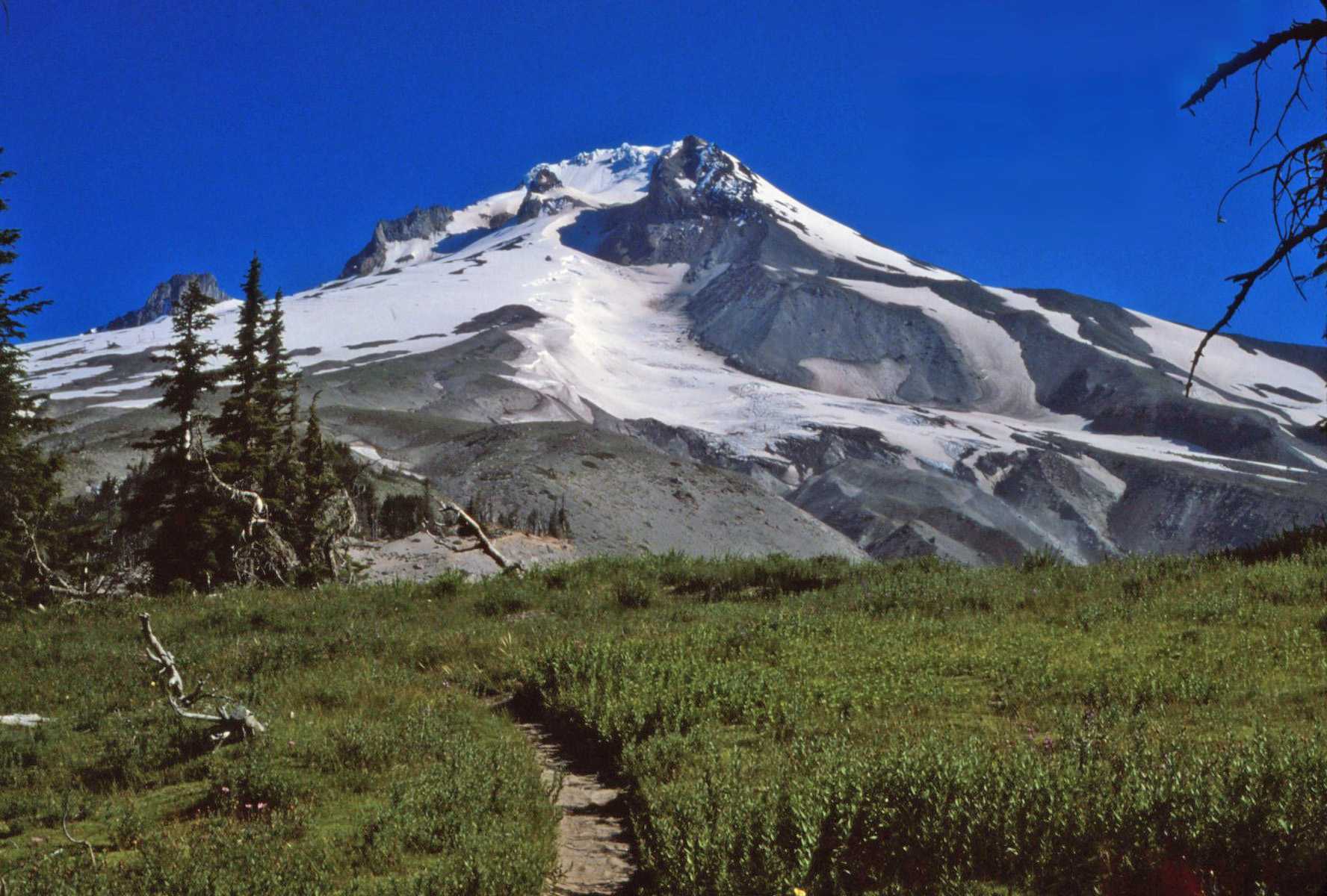


Day 78 July 21
I'm finally getting some summer weather; sunny, hot and humid. Hot means 80 in the mountains. There's a good breeze keeping things cool. I expected I'd be descending toward the gorge most of the day. Instead I climbed most of the afternoon. I'm only a few miles from the river, but thousands of feet above it. There are 10 trail miles to Cascade Locks, all down hill I hope. Most of trail was wooded, but there were a few open stretches with excellent views. I could see Mt. Adams, Mt. St. Helens, and Mt. Rainier to the north and Mt. Hood and Mt. Jefferson to the south. There hasn't been a cloud in the sky all day.
Tonight I'm camped on a ridge top with an excellent view east. I walked 1/2 mile down a side trail for water and carried it back to the PCT. There are very few bugs here so I may not pitch the tent. I'll be in town by noon tomorrow.

Day 79 July 22
I was up at the crack of dawn today and moving down the trail before the sun was up. It was a long down hill hike as I dropped thousands of feet into the gorge, which is less than 100 ft. above sea level. Numerous long switchbacks brought me down, though the trail was often quite steep. I got into town by 10:00 and had no trouble finding the Post Office. The sign on the door said "closed Saturday". Fortunately a girl was working in the back room sorting mail and she got mine for me. I got several letters including one from M/M Mars containing coupons for 1 1/2 lbs. free candy. I'd written to them complaining about stale candy I got several weeks ago. I also got a package of homemade goodies from Bob and Charlene, troop leaders of Troop 111 whom I met way back in southern California. They sent homemade bread and jam, gorp and a jar of apricots. I wrote them a few weeks ago but I never expected this response. My first paycheck from the "Sampler" finally caught me after being forwarded four times and I got letters from Susan, Jean and Red, and Ann and a postcard from Jeff Lance, a hiker with whom I rode from Weldon to Beldon. I also got a letter from Jeff Middlebrook who drove us to Beldon.
There's a beautiful park on the lake here in Cascade Locks with water, picnic tables, and even free showers. I've been here nearly all day writing my report for the Sampler. The weather is sunny and very hot. I stopped at the supermarket, which is large and well stocked, for ice cream, bananas, chocolate syrup and crushed pineapple and made myself a huge banana split. I also got liverwurst and cheese for lunch and a tomato and cucumber.
Tonight I'm going to stay on a small island that is part of the park. There's a few bunches of trees on it and I should be able to unroll my sleeping bag inconspicuously. I washed my clothes at a Laundromat and had a hot shower - great to be clean again. Tomorrow I'll stay here writing letters and relaxing before starting for Weldon Monday.

Day 80 July 23
Today was another hot humid day of sitting in the park resting and writing letters. I bought a bunch of fresh fruit for breakfast and had cheese sandwiches for lunch. Several other picnickers stopped to chat with me and one group gave me cake and homemade ice cream while another offered a bottle of soda. I toured the area this afternoon and learned a little about the history of this place. I also watched the Indians dipping for salmon in the river with large nets and spent some time tanning in the sun. There was a stiff breeze blowing all day, which kept things cool. I packaged all the excess material from my pack and have several letters ready to be mailed out tomorrow when the P.O. opens. This evening I treated myself to a dinner of veal cutlet at a local restaurant. Tomorrow morning I'll stop in for breakfast before starting down the road. Tonight I've returned a short distance back up the trail to camp. It's a bit quieter here and it's also legal to stay here. Last night I was camped illegally on Thunder Island.
Day 81 July 24
I got up about 6:00 this morning and walked back to the park for a hot shower. Then for breakfast I stopped at the restaurant for hotcakes, eggs and ham. Afterwards I met a woman named Teddy Boston who, with her husband, was driving north to the trail's end in B.C. They were going to hike south from there through Washington. She had hiked the entire trail alone two years ago, one of the first women to do it alone.
When the Post Office opened at 8:30 I mailed off my package and letters and got another letter from Anni Clark. By 10:00 I was out on the highway hitching in light traffic. I finally got picked up by a man who said he'd take me to Portland but he wanted to travel on the Washington side of the Columbia. He really gave me a grand tour; we went miles out of the way. He took me several miles south of Portland on I5, which was really good. I'd been worried about hitching out of Portland. My second ride took a bit longer to get. The sun was strong and the air hot and heavy. After about an hour of standing by the hot asphalt I took a break and walked to the shade by the roadside. There a fence was covered with a tangle of blackberry bushes, which were drooping with ripe fruit. I stuffed myself. Finally I got a ride with a girl in a pickup truck who took me to within 17 miles of Salem, Ore. From there I called Anni who was visiting friends in the city. They drove out and got me and tonight I'm spending the night under a roof listening to good music and talking trail with Anni, Dana, Jereal and Jill. Anni made quiche and salad for dinner and we went out to a Baskin Robbins ice cream parlor for dessert. The banana split didn't rate too highly on my scale. I'll probably stay here tomorrow, there's an all you can eat special at Pizza Hut tomorrow night. I've got a few things to do in town anyway.
Day 82 July 25
It's still hot and humid. I washed my down jacket and sleeping bag in the bathtub this morning and they've been drying in the sun all day. The down in the bag isn't dry yet. We all went to Pizza Hut tonight for an all you can eat dinner. I got my money's worth in pasta, pizza, and salad, but I didn't overstuff myself. Tomorrow we're headed for the beach. I'll get a chance to wade in the Pacific. I should be on my way south again on Thursday. The weather's supposed to get a little cooler. Today would have been a hot day for hitching. I checked into Greyhound and the rates aren't too bad. I'll hitch as far as I can, then take a bus.
Day 83 July 26
Today for the first time I walked in the waters of the Pacific Ocean. Unfortunately the sky was cloudy and a cool breeze was blowing. But it didn't rain and the beach was nice anyway. We left Salem about 10:00 and were on the coast by noon. By 7:00 we were back home. This evening we went to dinner at a Mexican restaurant. The food was excellent. I finished the meal with a banana split at a nearby ice cream parlor. It was better than Baskin Robbins. I bought a new watch this morning - a waterproof Timex. My old one stopped for good. I'll be moving south again tomorrow.
Day 84 July 27
I said good-by to Anni, Dana, Jill and Jereal this morning and once more hit the road. The sky was completely clouded over which at least made things cool. I waited about a half hour for my first ride, a 70 mile trip with a musician. Then I waited 1 1/2 hours for my longest ride of the day with a WWII veteran who was driving to Medford. He treated me to lunch at a roadside diner. My last ride of the day was a 60 mile trip in the back of a pickup truck. I'm now back in California at Castle Craigs State Park in Castella camped in the same spot I occupied on June 14. I was hoping to find some PCT hikers here for possible news of the Sierras, but I haven't seen any. I'll check out the PCT register in the P.O. tomorrow before I head out. Its just over 400 miles to Weldon. I'll see how far I get before the heat gets to me.
Day 85 July 28
Today I moved 6 miles north, back up the freeway to Dunsmuir. I decided hitching in California was something I don't care for. There was practically no traffic on the entrance ramps at Castella. Today was a hot sunny day and I quickly got tired of standing out in the sun, so I called Greyhound in Dunsmuir and was quoted a price of $26.36 for passage to Bakersfield, about 500 hot miles away.
I met another PCT hiker in Castella who had good news about the Sierras. He was there last week and the trail was snowy but passable. I'm a bit relieved. I couldn't even hitch a ride to Dunsmuir and had to walk six hot miles. It was probably good for my legs; it's been so long since they had any kind of workout. I celebrated arrival in town with a banana split and a quick visit to the supermarket. Now I'm waiting for the bus in a small hot waiting room. It's supposed to get here at 5:16. I'll ride all night and get to Bakersfield at 6:30 tomorrow morning. I'm even starting to look forward to the Sierras. There's still a 40 mile hitch from Bakersfield to the trail.
The PCT hiker I met in Castella hiked the AT the same year I did. He started ahead of me and finished after I did so I passed him somewhere along the way though I don't really remember it.
Day 86 July 29
I spent all night trying unsuccessfully to sleep on the bus and I'm feeling the effects of my lack of sleep today. The bus got to Bakersfield about 6:30 this morning. Fortunately the bus station was only a block from I73, which goes to Weldon. It took about 1 1/2 hours to get a ride from Bakersfield to Weldon, but the trip only required one ride. The road followed the Kern River, which is still flooded from melting snow. It twisted and wound its way up the canyon.
I got to Weldon about 10:00 and waited three hours for the P.O. to open. The temperature was in the low 90s but there was a nice breeze blowing. It's quite a change coming back to these hot dry hills after spending so much time in the cool green pine forests in the north.
Once again luck was with me as I went to get my mail. They still had my old forwarding address card on file and had readdressed and prepared to forward my mail yesterday. But, for some reason, it didn't get sent out and I was able to claim it. I already sent cards to Mammoth Lakes and Echo Lake asking them to disregard my previous forwarding address cards.
This afternoon I bought provisions for 18 days. I spent less than $30 but my pack is stuffed. It's going to be a hungry 2 1/2 weeks though. I just can't carry enough to feed myself. I still need more bread and candy bars, but I think there's a store at Kennedy Meadows a couple days out.
There was a post card in the P.O. from someone who had gone through the mountains in June, so I'm sure I can get through now. Tonight I'll camp near South Fork and tomorrow I'll get an early start. It's going to be a steady climb.
Day 87 July 30
Today has been a long uphill day. It doesn't get light as early here as it did in northern Oregon and it was semi dark when I got up this morning at 5:00. By 6:00 I was moving up the dirt road that is the temporary route out of town. Weldon is at the edge of the desert at 2651 ft. Except for the past mile I've been hiking uphill all day, reaching a high point at 8340 ft. It wasn't too bad breaking my legs in again, though the trail was in bad shape most of the time. I took my time and took plenty of breaks. I climbed out of the desert along Fag Creek on trail that was quite steep, but fairly easy to follow. Once I reached the Kern Plateau, however, the trail got really bad. Except for the occasional PCT markers I'd never have believed I was on a trail. It was more like walking in a washout and often very steep.
As I got higher I left the barren desert behind and entered pine forests. I think I've been spoiled by the lush greenery of Oregon. California forests, at least here, are rather sparse. The land around the trees is usually bare, sandy, and hot. It's definitely summer here, even at this altitude. The temperature get into the 80s and the sun beat down relentlessly. The trees didn't offer too much shade. It's hard to believe there's much snow just 3000 ft. higher. It'll be a couple days before I climb above 10,000 ft. The areas between the mountain peaks here are often occupied by large alpine meadows made lush and green by springs and streams that flow into the flatland. Tonight I'm camped next to Big Meadow that, like most of them, is fenced in and full of cattle.
I'm camped at 7960 ft., higher than I've been in over two months. Tomorrow I have one steep climb and then lots of downhill. The mosquitoes and flies are swarming around, but they're not as bad as the ones in Oregon.

Day 88 July 31
I overslept today and didn't awake till nearly 6:00. I waken when the sky starts to get light and it doesn't get light as early here as it does up north. Before I was done with breakfast the silence of the woods was broken by the chatter of two helicopters. The forest was being selectively harvested and a big chopper was being used to haul the logs out.
I walked through Big Meadow among the cattle through lush grass wet from the dew and occasionally flattened by the cows. Then I entered the forest and started climbing, gradually at first, then very steeply gaining 1200 ft. in two miles. By 9:30 I was at the ridge crest at 9200 ft. and to the north the High Sierras rose into the sky. There were patches of snow, but nothing that looked too bad. For the rest of the morning I descended, giving up altitude I'd worked so hard for.
Today has been a very hot day. The forest became very sparse, then disappeared and I was once again hiking the dry sandy hills through scrub growth, back in the southern California desert. But this time the temperature climbed into the low 90s. Frequent streams and a nice breeze offered me some relief, but the sun was intense. All afternoon I've been hiking on dirt road that was rarely shaded from the sun. The sand beneath my feet was heated and the soles of my boots warmed up. I met two other PCT hikers trailside this afternoon. They started in Mexico and are headed for Oregon.
Tonight I'm camped on the bank of the mighty South Fork of the Kern River on a site that was flooded two months ago. This river was unfordable then, and those hikers that crossed, swam across. Today I ended my long hot dusty hike with a swim in its cool waters. The river is knee deep and easily walked across. Air temp is still 82 at 6:00. I've been sharing the trail with cattle all day. Tomorrow morning I'll reach a small camp store at Kennedy Meadows. I need bread, peanut butter, jelly and maybe some ice cream.
There were hundreds of tiny frogs - maybe peepers - on the trail this morning. They hopped and flopped out of my way as I approached.

Day 89 August 1
My opinion of the Sierras improved greatly today. The morning started with several miles of following ribbons over boulders along the South Fork of the Kern River. There was no trail, just ribbons. That was followed by a couple miles of walking on dirt road to the store at Kennedy Meadows. I added a couple pounds of bread, candy bars, peanut butter, and jelly to my pack. A couple quarts of milk, some zingers and oatmeal creme cookies were eaten on the spot. Prices were high, but that's to be expected in a little camp store. There was no phone and a generator in the back room provided electricity. From the store I walked a paved road to Kennedy Meadows Campground where I picked up the trail. It was a hot sandy trail through sparse woods along the Kern River. The hot sun beat down on me and the white sand reflected the heat upward. I was drinking water by the quart and sweating it out as fast as I drank it. The air was very dry and my mouth and throat would quickly become parched. The forest was sparse and the ground sandy. It wasn't my idea of good hiking. About 1:00 I crossed the Kern River, wading across in thigh deep water. It was so refreshing I stopped for a swim. Across the river I again climbed on hot dry trail, crossing a couple mountain meadows. Cattle had free run of the trail. They trampled the meadows, deposited obstacles in the path and scented the air with an aroma all their own. They also polluted the water.
As I climbed higher things began to improve. The forests became more varied and more dense and shrubs filled the space between the trees. Late this afternoon I sweated my way to an 8000 ft. saddle between two impressive looking peaks. When I reached the crest, instead of finding a valley on the other side, I found a vast alpine meadow. The land stretched ahead of me for miles, tinted various shades of green by the different types of grass growing there. The mountain beside me, which had looked so awesome from the valley, was just a hill at the edge of the meadow. Cattle grazing on the lush grass dotted the field in the distance. I followed the trail for miles through the grass and finally once again reached the Kern River. Again I waded across and again stopped for a swim. Tonight I'm camped beside it again. The temperature up here is much cooler and a nice breeze is blowing. Scores of cattle are grazing in the field around me, bawling and bellowing into the evening. Olancha Peak rises to 12,123 ft. from the edge of the valley. Near the summit a single speck of snow remains. There should be lots of dry trail ahead.


Day 90 Aug.2
The coyotes came out of the hills and down to the river last night and really made a racket. It was a mistake to camp by the river. I didn't pitch my tent and there was a heavy dew. The temp dropped into the 30s and my sleeping bag got wet. I stayed warm though. I've done a lot of climbing today, both up and down, starting and finishing the day with prolonged climbs. The high mountains have been in sight all afternoon. The snow still doesn't look bad.
Hiking in these mountains is more like hiking in the desert than hiking in forests. The trees are rather sparse and don't give much shade and the ground is usually covered with white sand which reflects the heat of the sun. There are springs though, and where the water comes out of the mountain lush meadows abloom with wildflowers abound. The valleys into which the streams flow are also green.
The forests have a beauty of their own. Many trees have been killed by fire and the trunks stand bleached by the sun and stained from within a beautiful hue of red. Their trunks and bare branches are twisted and gnarled. The living trees are also beautiful. Most are quite old and gnarled with pretty red bark and short twisting branches.
The mountains I've been climbing this afternoon have huge boulders of granite scattered about, stacked and sculpted by the wind and weather into a thousand interesting shapes. The mountaintops are chunks of stone fractured into a thousand pieces and fitted together like some crazy jigsaw puzzle. Tonight I'm camped atop one such mountain above 10,000 ft. To the east the land drops 7,000 ft. to Owens Valley. To the west lie a jumble of mountains and meadows. I'm melting snow from the only snow bank I've encountered for water. Tomorrow I may get to climb above timberline.


Day 91 Aug. 3
It didn't get cold as I expected it to last night. The temperature was 50 when I got up this morning. I left all my pots and pans out full of snow and had a good supply of water this morning. I'm finally into the high country where the trees end and the bare rock begins. There wasn't too much climbing involved today and the trail was generally good. I quit for the day about 3:00 so I could camp near Chicken Spring Lake. A mountain of granite with patches of snow rises behind the lake. There were about 18 boy scouts camped here when I arrived, but they all packed up and moved out. I guess they're just getting started. It's about 16 miles from here to the John Muir Trail that leads to Mt. Whitney. I want to camp at the base tomorrow and climb the mountain without my pack Saturday. It's 9 miles to the summit so it should be an easy day's hike. I can feel my pack getting lighter every day. It's a real challenge not to eat more than my daily ration but I've got to make it last.


Day 92 Aug. 4
Today's been a day of thunderstorms complete with rain, hail, lightening, and thunder. The sky was relatively clear when I got up this morning but clouds moved in to the west of the ridge I was walking and the thunder started booming. I got only a few sprinkles and by noon the sun was shining again. Hiking these mountains is getting kind of monotonous. The trail is always hot, sandy and dusty and the trees never change. The mountains are all piles of granite and lack character. I hope things improve. About 3:00 this afternoon I crossed Whitney Creek, a fairly good-sized stream. I stopped to wash some of the trail dust off me when out of the blue a thunderhead appeared and started pouring on me I covered the pack and ducked under my sportsman's blanket hoping to wait it out. It rained and hailed and thundered for 1 1/2 hours before it eased up. I only had a couple miles further to go anyway so it didn't matter.
Tonight I'm camped near Crabtree Ranger Station. I'm going to climb Whitney tomorrow without my pack. It's only 8 miles to the summit. Now it's raining lightly again. The thunder's still rumbling around the mountains. I hope its clear tomorrow. If the rain continues I may just move on and forget Whitney. I saw only 3 other hikers on the trail today.

Day 93 Aug.5
The weather was beautiful this morning for my 3,854 ft. 8 mile climb to the summit of 14,494 ft. Mt. Whitney, the highest mountain in the U.S. outside of Alaska. I started hiking about 6:30 carrying my lunch, camera, lens and water bottle. By 10:00 I was on top after passing several pack laden hikers on the way up. Mine was the 1,051st. name on the trail register for this year. It's an easy trail to climb and is accessible from a road end at Whitney Portal 10 1/2 miles from the summit. I met a hiker on top from Medford, Mass. and another who emigrated west from Williamstown ten years ago. On my way down I passed dozens of people headed for the top. The trail was practically snow free and the view from the top was magnificent. As I descended clouds began to form and before I got back to my pack I was showered upon a couple times. But the sky stayed partly sunny and the rain wasn't very heavy.
This afternoon I've hiked about 6 miles to camp beside Wright Creek. I've seen several other hikers on the trail, but it's still not as crowded as the Appalachian Trail was in New Hampshire. I'm now on the John Muir Trail, which I'll be following for nearly 200 miles. Tomorrow afternoon I'll cross Foresters Pass, the highest point on the PCT. This side of the pass is snow free but there's snow on the north side. Plenty of hikers have been through though.
The thunder was rumbling and dark clouds prevailed to the north and west this afternoon but I stayed dry. The clouds always dissipate at night and skies are clearing now.
I've been encountering mosquitoes all day but they aren't too bad here. They were horrendous at Wallace Creek, about a mile back. I took a sponge bath in Wright Creek and washed some clothes. The water is too cold for total immersion, but I managed to get fairly clean. At least I washed off all the dead mosquitoes. On the way down Whitney I saw a marmot, a woolly woodchuck like creature that is one of the few creatures to inhabit the high country.


Day 94 Aug. 6
The climb over Foresters Pass presented no problem. Most of the morning I climbed gradually, much of the way above timberline. There were dozens of marmots scurrying among the rocks. I got some good pictures. The last couple miles were up the face of a cliff via switchbacks, which were literally cut into the face of the mountain. The lakes at the base of the pass were still mostly icebound but there wasn't much snow on the trail. I ate lunch at the top, at 13,200 ft. it's the highest point on the PCT. There was more snow on the north side of the mountain and I had to slog across several mushy snowfields. Gradually the snow ended and the trail resumed, descending beside a creek. All afternoon I've been hiking down, but the trail was quite often in very poor shape, washed out or full of water. The mountains have become more interesting though, with smooth sheer granite cliffs and pointed pinnacles. The forest here is also a bit denser and greener with grass and wildflowers common. Tonight I'm camped at Vidette Meadows, at a well-used campsite in a popular camping spot. There's several others camped here but none are in sight. I'm now down to 8,600 ft. Tomorrow morning I start climbing again back to over 11,000 ft. The thunderclouds appeared this afternoon as usual but they all stayed west of me. Mammoth Lakes is about 8 days away.


Day 95 Aug. 7
It rained on me yesterday evening before the sky cleared and the evening clouds have again rolled in and thunder is crashing all around. It's sprinkled a bit but hasn't rained hard yet. This morning I climbed from 8600 ft. over 11,978 Glen Pass. It wasn't really much of a pass, just a place where the trail shot up and over the ridge via multiple switchbacks and then descended the other side the same way. I passed dozens of hikers, mostly near Roe Lakes, a very popular camp spot. The trail followed the south fork of Woods Creek down to 8492 ft. From there I climbed along Woods Creek back to 10,400 ft. where I'm camped beside Twin Lakes. I've traversed over 1 1/2 vertical miles.
The hike up beside Woods Creek was quite enjoyable. The river is vibrant and alive thundering and crashing its way down the canyon. There were several waterfalls. The banks of the stream were green with grass sprinkled with red columbines, daises, thistle and buttercups. There were occasional stands of pine and even a few groves of beech, about the first non-evergreen I've seen in the Sierras. Most were just saplings but there were a few that reached 30 ft.
Tomorrow I'll cross two passes, Pinchot at 12,110 ft. and Mather at 12,100 ft. But I only descend to 10,040 ft. between the two so it should be an easy day. My pack is really starting to feel light.
I saw three deer trail side this morning - two bucks and a doe. They weren't particularly frightened of me. I also saw more marmots.


Day 96 Aug. 8
I've never seen so many fish as I did last night at Twin Lakes. The lakes were fairly shallow and not too big but there were hundreds of fish. After the rain they were surface feeding and jumping for flies. It looked like rain was falling on the lake. I got my pole out and hauled in five in nearly as few casts. They weren't too big but they sure were tasty.
Today I crossed two passes. Pinchot wasn't bad at all. There was only a little snow and I crossed it easily. I saw a herd of five deer on my way up. As usual I followed one stream down and another back up to the second pass. The climb was very gradual and pleasant through a valley that was broad and green and lined with towering gray peaks. The second pass was rougher than the first. The bottom 500 ft. of switchbacks were under snow so I climbed straight up the snow bank. The north side was also snowy and I skied down a good part of it. I fell into a river on my way up to Mather Pass. There was a log across the stream and when I was midway across it slid out from under me. Fortunately I had enough momentum so I landed on the other side. Both feet got dunked and I had to stop and wring out my socks. No damage done though.
Tonight I'm camped beside Palasades Lakes. I barely beat a thunderstorm to camp. The wind was picking up and the thunder rumbling so I took the first site I found and pitched the tent. I was putting the fly on when the storm hit and I had to tie the last few lines in pouring rain. It hailed and blew but the tent held and I stayed dry inside it. The rain is just easing up now and the sun is half out. Almost time to try fishing again.
The next pass I cross, Muir Pass, is supposed to be very snowy. I'll hike to its base tomorrow and attack it fresh in the morning before the snow gets too soft. I think I have enough food for a double dinner tonight. I sure could use one.

Day 97 Aug. 9
I nearly had my tent blown away last night. About 10:30 I was awakened by the flapping of the fly in the wind. A storm was approaching from the mountains. The tent site was totally out in the open in sand. The stakes usually couldn't take too much pulling. As I lay inside hoping the wind would quit one of the stakes pulled out and the fly started flapping wildly. I quickly got up and reset it but it held only a couple minutes in the gusty wind and when it gave way two other stakes came up with it and the fly blew off the tent. Fortunately it wasn't raining yet. I got up again and managed to get the fly back on, anchoring the stakes with large boulders. Once again I returned to my sleeping bag and listened to the wind blow and the tent flap. It seemed like it would be torn to shreds any minute. Something had to be done. I got up, got dressed and went out. I sat upwind of the tent and held it with my hands. It rained only very lightly and I was wrapped in my sportsman's blanket so I was warm and dry. Finally the wind quit. I looked up and saw stars. The dark cloud had passed.
Today has been a good day of hiking. I walked down one river valley and up another. As I get further north I'm enjoying these mountains more. The valleys were green with grass and flowers. Sometimes there was a thick pine forest and sometimes open meadows. The mountains towered on either side. Even the hike uphill wasn't bad with plenty of greenery and waterfalls along the way.
Tonight I'm camped above a lake a couple miles from Muir Pass. This promises to be the snowiest pass yet. From here on up it's pretty steady snow. I stopped hiking early so I could choose a site carefully and be ready for the afternoon showers. It looks like they're ready to start.
I'll climb through the snow early tomorrow morning before it gets too soft and mushy. I'm sure there are plenty of footprints. I've passed dozens of other backpackers today, most of them coming down.

Day 98 Aug. 10
Muir Pass was much easier than I expected. The climb was gradual and the snow intermittent. It was solid enough this morning when I walked on it so that I hardly got my boots wet. There's a stone hut atop the pass and several hikers had camped there overnight. Two of them I had met back in May in southern California. It was a pleasant reunion.
Nearly all day I've been walking downhill, first down Evolution Valley, then down the San Joaquin Valley. Tomorrow, after a couple more downhill miles, I start climbing again. The valleys were really pretty to walk through with thick pine forests and open flowery meadows. I had to wade across thigh deep, ice-cold Evolution Creek. Again I met dozens of hikers on the trail.
Today's thunderstorm started out with some hail and is now directly over me. The thunder and wind followed me all the way down the valley, but I got set up before it started. Lightening is striking all around and the thunder's booming and echoing up and down the canyon. I'm camped in a nice pine forest near the San Joaquin River just below 8,000 ft.
I saw several mules and horses camped trail side. I suspect there are fewer than normal this year because so many of the passes are still in snow and impossible for them.


Day 99 Aug. 11
It rained nearly till dark yesterday. I finally gave up waiting and cooked dinner in the rain. I wasn't done till nearly 9:00. Today dawned mostly cloudy but then cleared. All morning I climbed to Selden Pass and crossed over just before noon. Near the top I met two hikers who had been in Castella, Ca. the same time I was - another reunion. The mountains and valleys are getting greener and prettier. Nearly all afternoon I walked down hill. I waded across hip deep Bear Creek. The current was swift and I almost didn't make it. A quarter mile downstream there was a log bridge, but I didn't know about it till I passed it.
The mosquitoes along Bear Creek really started to get bad and the thunderheads gathered and rumbled behind me. It started sprinkling so I stopped to don rain gear but the storm stayed behind me. Late this afternoon I started climbing Bear Ridge. I'm camped beside a stream close to the top. I took a sponge bath in the ice-cold water and even washed my hair under a small waterfall. It was really getting grubby and I couldn't stand the way it felt.
The thunder was crashing on the ridge across the valley, but the sky above me is still quite bright and I may escape the rain. It's getting a bit windy though.
I have plenty of company on this trail; everyone from toddlers to senior citizens has taken up backpacking. I'll be in Mammoth Lakes in two more days. I'm enjoying cleaning up my remaining food. I saw a lone deer beside the trail this morning.

Day 100 Aug. 12
This morning dawned cloudy and for a few hours I walked through intermittent showers and even a bit of sleet. By midmorning it eased up and the sun made a few appearances. I had a rough time fording North Fork Creek this morning. The log bridge had broken and been washed out. It was too swift a stream to wade through. There were a couple logs across but they were wet and slippery. I looked around for another way to cross and, finding none, finally crawled across one of the logs on my hands and knees.
As I neared Silver Pass the sky behind me grew dark again and a stiff breeze blew light rain into my back. Ahead, across the pass, the sky was mostly clear. I finally reached the top just after noon and started down the other side. The Silver Divide acted like a huge dam to hold the clouds back. Within a half hour I was in the sun and it's been mostly sunny all day. The trail descended to Fish Creek, then climbed to Tulley Hole where it left the valley and climbed straight up the mountainside. From the ridge top I looked back over Silver Divide. The sky beyond was still dark and cloudy.
Tonight I'm camped near Purple Lake. Today's showers haven't materialized yet and the sky is still mostly blue. It's quite cold though and also windy. I'm camped above the lake in a pine forest that shelters me from the wind.
With a little luck I'll be in Mammoth Lake tomorrow afternoon. My pack is nearly empty and with no weight I've been able to move quite fast. If the weather's good tomorrow I'll have no problem. I've begun to encounter volcanic rocks. There's also supposed to be some hot springs near here.

Day 101 Aug. 13
There was a touch of autumn in the air this morning as dark clouds raced across the sky on icy winds. It remained cool all day though the sky cleared and the sun came out. I had an easy hike down from Purple Lake. It was all downhill and most was on newly built trail. By mid day I reached Reds Meadow Resort from which a road led down to the town of Mammoth Lakes. On the way in I passed a large pack train with a couple dozen horses and mules. I also passed a large trailside spring. The water just gushed up through the sand at the bottom of a pool. It was a pretty sight. I've spent the afternoon writing my report for the paper. Tonight I'll camp somewhere around here and tomorrow hitch into town for mail, food and supplies.
For once the sky has stayed clear all afternoon. It's going to be a cold night but it should be a dry one. A lot of the hiking this morning was ridge walking which I particularly enjoy. I walked high above Fish Creek among nice pine forests. With a little luck I'll be able to finish my business in town tomorrow and be back on the trail Tuesday. Tonight is clear and cold. The moon is getting fuller and it's going to be quite bright.
Day 102 Aug. 14
I was out by the roadside shivering and hitching early this morning. The temperature dropped to near freezing. There was very little traffic but the second car by stopped. It was the first time I've been picked up by a RV. The road was a small dirt one and it was cold so the driver felt sorry for me. The road was in really rough shape and it took nearly an hour to go the 15 miles into town. I got mail at the P.O. and then found a restaurant with a breakfast special that included hotcakes. In small print it said, "We serve four but you can have more." After I'd eaten 20 the waiter started avoiding me. It was almost lunchtime anyway so I really didn't care.
The shoulder straps on my pack were starting to wear. I stopped at a backpacking store and got them replaced for free. I also visited the Laundromat and supermarket. This is quite a big town - tourism and skiing. I got another paycheck from the Sampler and treated myself to a dinner of lasagna at an Italian restaurant. It was a nice meal but would have been better it I wasn't dining alone.
Tonight I'm camped in a Forest Service campsite at the edge of town. A camper who was leaving ahead of schedule left me his prepaid site. There are no showers here though.
The weather's been clear and cold all day. This is really good hiking weather and I'm anxious to get back on the trail. I'll hitch back out tomorrow. For breakfast I'm going to try to get donuts from a local bakery.
Day 103 Aug. 15
I had three overpriced donuts, some milk, two bananas and a couple candy bars for breakfast. Then I walked a mile to the beginning of the road to the Devils Postpile and waited for a ride. There was hardly any traffic but I got lucky and after about 15 min. got picked up by a young couple in a VW bus who took me all the way in. We had a good talk on the way in about hiking, wildflowers, and the Sierras in general. By 11:00 I was back on the trail. Most of the day I've been walking uphill on dry sandy trail. It's been a cool clear day, excellent for hiking. I can really feel the weight of my pack now. I've 10 days of food packed.
I'm now hiking below the Minarets, a range of very jagged peaks. There's a lot of lava around now also. This is a very popular part of the Sierras. I passed Shadow Lake late this afternoon and there were dozens of people camped around it and dozens more on the way in. Hiking the trail was like walking a city sidewalk. People walked by, eyes straight ahead ignoring those around them. I continued on a couple miles past the lake and am camped by a stream a short way off the trail. It doesn't look like anyone's camped here before and there's no one else around. The sky is crystal clear and it's starting to get chilly though the sun hasn't gone down yet. It's going to be a cold night.
Tomorrow I'll climb over Donohue Pass into Yosemite National Park. Once I'm over the pass I'll have a long stretch of downhill walking. I hope Yosemite isn't as crowded as this area is.
Day 104 Aug. 16
Today's been a cool, very windy day. It started with a long climb and finished with a long gradual descent. In between I crossed two passes, Island Pass, which was quite easy, and Donohue Pass, which wasn't too bad either. There was only a little bit of snow on both passes. The wind has been gusting out of the west all day. I had to fight my way up into it on the last mile of the climb over Donohue Pass and on the way down it pushed and shoved me in directions I didn't want to go. The sky's been mostly clear all day with cottony white clouds speeding by. This trail continues to be in rough shape. The climb up Donohue was fairly gradual but coming down was really steep. The switchbacks were rough and rocky so that descending was almost as hard on the legs as ascending. After about 4 miles of steep trail the route leveled off in the broad flat Lyell canyon. Walking then was easy on smooth trail. I have about 4 more miles of good canyon walking before I get to Tuolome Meadows. This canyon is notorious for its bears, which have developed a taste for backpacker food and have the cunning to get it. My selection of a campsite depended on the proximity of a good bear bag tree as much as on shelter from the wind. It used to suffice to hoist the bag up 10 ft. and tie the free end of the rope around the trunk. But the bears learned to untie the rope or chew through it. Now you have to counterweight the food bag and get everything 10 ft away from the trunk and the ground.
There were quite a few hikers on the trail today, but not as many as yesterday. I'm now in Yosemite National Park. Tomorrow morning the trail will cross the first highway it's encountered in more than 250 miles.


Day 105 Aug. 17
I hoisted my food bags 9 ft. off the ground last night and pitched my tent about 30 ft upslope from the tree. Just before midnight I was awakened by the crackling of branches in the direction of my food. I got up and flashed my light in the direction of the noise. A pair of luminous eyes reflected it back to me. The bear had climbed a smaller tree near the food bag in the hopes of reaching out to it. It couldn't. I yelled and pitched a few stones at the beast. It snorted and went galloping off through the woods. The moon was nearly full and I could just see the bear in the shadows. About an hour later I was just dropping off to sleep when I heard a stick break. Sitting up I peered out my tent window toward my food but could see nothing. I thought I'd better check anyway and turned my attention to the tent door just in time to see a bear high tailing it about 10 ft. away. Apparently it came to investigate my cook kit, which I'd left out. I let out my most ferocious yell to hurry it on its way, and then pitched a few stones after it for good measure. Again at 5:00 this morning I heard the crackling of branches and got up to chase a bear away. These animals scare me. Wild animals usually fear man and will cause no trouble unless threatened. These bears have become used to people and maybe even dependent on them. They're bold and unpredictable.
I walked downhill on excellent trail through frosty meadows this morning to Toulumme Meadows and the first civilization the route has encountered in a long time. There were lots of cars in the parking lots and dozens of people on the trail. There was a soda spring with naturally carbonated water trailside and with some lemonade mix I made myself some lemon soda. There was also a totally misplaced sign near the spring that led me a mile out of my way. Nearly all afternoon I've been walking up Cold Creek Canyon on excellent trail through meadows and forests. It was really enjoyable hiking, the weather was sunny and cool. I passed a mule team along the way. This trail is well used. In places it's four lanes wide though usually it's just two. The PCT and the John Muir Trail diverged several miles back and the path improved greatly. They've recently done work on this trail and it's in good shape.
Tonight I'm camped beside a creek in a grove of pines. I talked to people who camped near here last night and they reported no bear problem. Just the same my food will be hung. I found a good tree where they'll never get it. This morning I found deep gouges in the trees around my food cache from where the bears had been climbing.
There are dark clouds overhead now but there are still patches of blue between them. The cool weather has really eased the mosquito problem.
After the second bear left last night the coyotes started howling. First a lone coyote would give a long lonely bark. Then, from somewhere in the distance, another would answer, and then another and still more would join in rising in crescendo and finally reaching a frenzy of yips and yelps. Then all would be silent again.


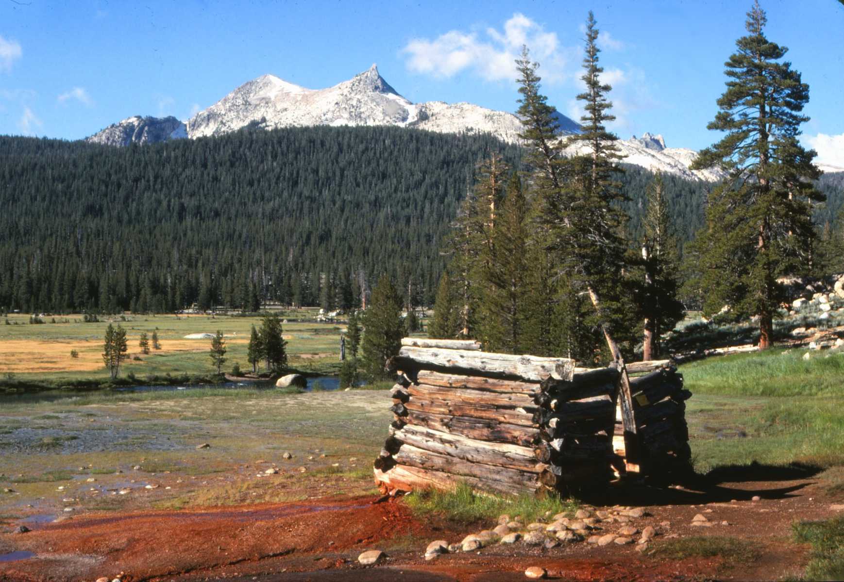


Day 106 Aug. 18
I wasn't bothered by bears at all last night. It sure was cold this morning - below freezing. It's been clear and cool all day - beautiful hiking weather. I walked through frosty meadows this morning until the sun came up. It's been a rough day - lots of climbing on poor trail. I started the day with a steep climb up to Bonson Pass (10,140) then descended steeply to 7590 ft. then finished the day with a steep rocky climb to Seavey Pass (9150). Tonight I'm camped on a steep mountainside just off the trail in Kerrick Canyon. My tent is pitched on a slope above a tree but I don't expect I'll have any trouble sleeping. A bear would have to be crazy to climb up this trail so I don't think I'll bother hanging my food. Tomorrow should be a much easier day. It starts with 3 miles of downhill and I'll spend most of the day on a long gradual climb out of Yosemite.
Today's been a very scenic day. The mountains here are gigantic chunks of white granite that have been shaped and polished by glaciers. Some of them are quite spectacular. Most of the trail was wooded and lined with grass and wildflowers wilted by the frost. One short section near Benson Lake was in terrible shape. The trail led through a swamp and was soggy, mushy, and blocked by downed trees. I didn't see too many people out here today, less than a dozen. I expect it's because I'm getting away from the heart of Yosemite.

Day 107 Aug. 19
I was awakened by a thump and the crackling of brush last night. The first thought that entered my mind was "bear". I panned my flashlight around the area and spotted two red eyes bounding up the slope, too fast for a bear, just right for a deer.
This morning dawned with a full moon still shining, much warmer than yesterday. Hiking today was a bit rougher than I expected. I started with a gradual descent that was followed by two steep climbs and descents in the space of 4 miles. The trail was in rough shape and very tiring. All afternoon I climbed very gradually uphill in Falls Canyon. Finally late today I crossed Dorothy Pass and got out of Yosemite. Tonight I'm camped beside Harriet Lake. There are several other campers on the lake and one of them is hacking away at something. Tomorrow I'll be back on the old PCT, much of it temporary route over roads.
I didn't see too many people today till I reached Dorothy Lake where a couple dozen scouts were camped. I expect the number of backpackers will really decrease now that I'm out of the Parks.
The mountains are changing as I move north. The huge granite monoliths of Yosemite have been replaced by red and black piles of lava. There's still patches of snow around that probably won't melt this year.

Day 108 Aug. 20
All day I've been hiking on recently constructed trail that was good footing and very spectacular, staying near the Sierra Crest for miles. About 8:00 this morning I started climbing and continued gradually uphill all day. Most of the time I was on open barren rocky mountains made up of chunks of lava. The route climbed to 11,000 ft. and stayed high above the valleys. Below me the mountainside dropped thousands of feet. The sky was clear and the views in every direction excellent. About 3:00 I reached Sonora Pass and had to descend 1,400 ft. in about 2 1/2 miles. It's a real change descending for a pass. Tonight I'm camped a mile or so on the other side of the highway through the pass. Tomorrow morning I climb again but only about 500 ft. to start. There's been a cold gusty wind blowing all day. It was especially bad at the ridge crest, pushing and shoving me around. I've crossed more snow today than I had in the previous week - nothing difficult though. There were a few day hikers and several backpackers on the trail today. I met two whom I'd passed near Seiad Valley in northern California. They're headed south to Whitney. I learned the PCT has been completed for many miles ahead. It's going to eliminate a lot of extra miles on temporary trail for me. The mountains here are all red and black lava with peaks and pinnacles molded in weird shapes. It makes for interesting walking. I saw a couple deer trail side before I got above timberline.


Day 109 Aug. 21
I put in a long day today and hiked over 20 miles, most of it on fairly new trail. It was cold and windy this morning. The small ponds and streams near the mountaintops were frozen over and the hoarfrost crunched under my boots. The wind was gusty and incessant, blowing out of the west. The first couple miles in which I climbed up a treeless western slope were really cold. But then I got into a forested valley that offered protection from the wind and the sun warmed things up. The wild flowers along this section of trail were more prolific than in the High Sierras. There are several varieties blooming and an abundance of flowers. Maybe this is the right altitude for flowers. This trail was constructed as the PCT and stays quite near the ridge crest. Most of the mountaintops had trees that helped block the wind that hasn't stopped blowing all day.
The path is in very good condition, shaded by pines and carpeted with needles. Bright green staghorn lichen is again appearing on the trees. I saw lots of it up north. I met only 3 other backpackers on the trail today. Cattle once again have run of the range and I've encountered several dozen.
Some small clouds have begun appearing in the north, but other than that the day's been clear and cool. Tonight I'm camped in a pine forest near a spring the cattle haven't managed to pollute yet. It feels like it's going to be a cold night.


Day 110 Aug. 22
This morning was a bit warmer than the past few days but the wind continues to blow. It's been a very enjoyable day of hiking. The trail stayed high most of the time and with the clear sky the views were excellent. Sometimes I walked on carpeted trail in pine forests, sometimes through flowery meadows and sometimes among sagebrush. Most often I hiked dusty sandy trail that wound its way around the mountains below huge chunks of lava. The lava poked toward the sky in all kinds of shapes. Most of the trail was sheltered from the wind either by trees or by rock. I'm also hiking at a lower altitude so the wind isn't quite so cold. I met only one other group of four hikers on the trail today. They were just starting off as I walked by and they fell in behind me. It really bothered me to have that many people trooping on my heels so I stopped and let them get ahead. I passed them again while they were stopped for lunch but got far enough ahead so they didn't catch me. There were several deer and cattle grazing trailside in the meadows. This section of trail is really well built. The climbs are short and usually gradual and the footing is good. There was a beautiful display of wildflowers along the route.
Late this afternoon I began getting closer to civilization. There's a dirt road that parallels the trail route and quite a bit of traffic on it. I passed two parties beside a pond who were van camping. One of them had a trailer full of gear including a motorcycle. There's lots of garbage around also.
Tonight I'm camped amid the beer cans and litter beside a small lake that borders the dirt road. The water doesn't look too good but it's the only water around. There's no one else camped here but the litter and fire rings show this place gets used a lot. I'm only about 25 miles from Echo Lake.


Day 111 Aug. 23
The wind abated for a while last night but it picked up again today. I managed to stay out of it most of the time though. For the first time in a long while I did some road walking. It was dirt road though and only part of it was well traveled. I hiked past several lakes formed behind dams built by Pacific Gas and Electric. There were several camping areas and numerous campers on the lakes. At noon I crossed Carson Pass, named after Kit Carson who made the first winter crossing of white men of the Sierras through the pass. A good part of the afternoon I spent walking through meadows still ablaze with flowers. The more delicate blossoms have been nipped by the frost but there are still flowers everywhere. I met several other hikers on the trail, among them two guys I met near Seiad Valley in northern California. I think they're the last of the hikers I met up north who are headed south.
My pack is nearly empty of food. I've really been hungry the past few days and have eaten all I could spare. I'm only about 6 miles from Echo Lake and I'll reach the store midmorning tomorrow. Tonight I'm camped in a grove of trees in a west facing meadow. I'm fairly well protected from the wind and may get to see a good sunset, something I haven't managed for a while.


Day 112 Aug. 24
I didn't sleep too well last night. First the coyotes started making a racket. It wasn't an organized howl at all, just a lot of yelping and complaining. Then the wind started up again. My tent wasn't really well sheltered and it started flapping in the breeze, sounding like a snare drum. There was also a tiny mouse that kept running up and down my tent. Something chewed a hole in one of my socks and also made off with my plastic pot scrubber. This morning I hiked nearly all down hill, most of it very steep trail. Just as I was wondering if I was ever going to reach the road I came upon two girls camped by the side of the trail. It was Peg and Susan. They'd driven out to meet me, got here the afternoon before and camped where I wouldn't miss them.
Today's been a day of enjoying the luxuries of civilization. First I took a long hot shower, the first I've had in nearly a month. I stopped at Echo Lake Resort for mail, some of which hasn't come in yet. Then we drove to South Lake Tahoe for a stop at the Laundromat and supermarket. We called home this evening and talked with Dad. For dinner tonight I was treated to an all you can eat buffet at the Nugget in State Line. Salad, cheese, coleslaw, fruit, corn, potatoes and gravy, chicken, turkey a la king, pork chops and roast beef, I tried them all. I really filled myself but not to the point where I couldn't walk. For dessert we stopped at Baskin Robbins for ice cream. I had ice cream anyway. Tonight we're camped at the same spot the girls camped in last night. Tomorrow they're going to hike into Desolation Wilderness with me for a day, then return while I continue northward.
Day 113 Aug. 25
Today started with another cold windy morning. We waited till 9:30 for the Echo Lake P.O. to open and I got two more letters. Then we hiked on up the trail into Desolation Wilderness to Aloha Lake. The lake is one of the many around here dammed by PG &E to provide water for hydroelectric. They drain the lakes to provide water downstream. The water level is about 10 ft. below capacity and there's a thousand rocks sticking above the surface. We're camped in a nice pine grove on the east side of the lake. Barren gray mountains border the water on two sides. I spent the afternoon writing up my report for the "Sampler". We had a nice campfire this evening and toasted hot dogs for dinner and marshmallows for dessert. It's been a long time since I had a campfire and even longer since I had company to share it with. I've really been enjoying their visit.
Desolation Wilderness is supposed to be the most used Wilderness Area in California. It has been a bit crowded but still isn't as bad as parts of Kings Canyon Park. We've only hiked about 7 miles today. There's been some nice trail on the way. Meadows abloom with flowers and nice shaded forested path. Tomorrow I'll continue north while Susan and Peg head back to Echo Lake and on to San Francisco. This wilderness isn't too big and I'll be out of it in a day or two.

Day 114 Aug. 26
Last night wasn't as cold as the past few have been though it was quite windy. I saw a weasel near the lake early this morning. Susan and Peg walked with me to the north end of Lake Aloha and we parted company about 10:00 this morning. There were lots of people on the trail this morning but they were all happy and cheerful, sincere in their greetings and willing to stop and talk, quite different from those in the Minarets Wilderness. Desolation Wilderness is aptly named. Most of the day I hiked through rocky sandy terrain with only sparse forests. Late this afternoon things began to improve. The woods got thicker and grass and ferns appeared trailside. I got off the more popular routes and, though the path was in much rougher shape, I met only one other hiker.
I hiked till nearly 7:00 today without really wanting to. The creek I was depending on for water was dry as a bone and I had to move on till I found another source. I finally found a small spring and got all the water I need. I'm camped just outside Desolation Wilderness. There's no one else around and except for an occasional chattering squirrel or chirping bird all is silent.
Apparently the snow and rocks of the Sierras was too much for my boots. The stitching on the soles has rotted out and the soles and sub soles are starting to separate. They should make it to Belden but I may have to have them glued and nailed before I get to Washington. I wish I could find a backpacking store that would replace them for me. They're less than five months old.
I'm again on temporary trail that is not very well marked or maintained. Tomorrow I expect to do some walking on dirt roads and jeep trails.

Day 115 Aug. 27
The wind has finally abated and, though the mornings are still frosty, the weather is excellent for hiking. Most of the morning I walked on jeep roads and, though they were dusty and an occasional jeep or dirt bike shared the route, the hiking was very enjoyable. The road was lined by dense forests and lined with ferns, flowers and grass. As I was walking down one of the roads miles from any house a man came jogging up behind me. He was out for a 36 mile all day jog and carried no food or water. He stopped to have a look at my map and to talk for a while. Every morning he jogs and every weekend takes a day trip.
Further on down the road I came to a tiny cabin that is inhabited by a young couple during the summer. They had a PCT logbook out front and I signed in. There haven't been too many hikers through here who are trying to do the whole trail.
Late this morning I got off the roads and on to trail, though its still temporary route and doesn't stay near the crest. The path was often very dusty and the sun made things hotter than they've been in quite a while.
Tonight I'm camped next to Whisky Creek at the base of Squaw Mountain. I quit for the day at 4:30 so I'll have plenty of time to get set up. Last night was a bit rushed. I met 8 other hikers on the trail today.
Soda Springs is only 20 miles away. I'm going to try to get there by tomorrow evening. I won't have to buy much food; Sierra City is only two days further on.

Day 116 Aug. 28
Today's been a warmer day than I've had in quite a while. It's real Indian summer weather. The cold wind has finally ended and it's been clear and warm. I hiked on temporary trail all morning and dusty hot dirt roads all afternoon. There were only four other hikers on the trail today. This morning I climbed around Squaw Mtn. which has ski lifts on its east side. Lake Tahoe was glittering in the sunlight to the east. I saw a couple deer and a grouse along the trail. Just before noon I reached Old Soda Springs, which is nothing, more than a group of summer homes. From there to Soda Springs I walked on a very dusty dirt road, nearly all uphill, which was being used by a fleet of logging trucks. Everything within 10 yds of the road was coated with a layer of dust and I had a layer of it on me by the time I reached civilization. Soda Springs is a ski town and there's really not much here. I stopped at the general store for ice cream, bread, and candy. Sierra City is only two days away and I still have enough food left to get me there.
There was a sign by the side of the road marking the end of the temporary PCT. The route resumes two miles east of here at a freeway exit. I think I'll have to trespass to get there without walking on the freeway. Tonight I hope I can find a place to camp just outside town near the freeway. My map shows a creek and if its not dried up I should have no problem. I'll be camping on private property though and don't expect to get much sleep with all the freeway traffic.
There have been a lot of elderberries appearing trailside but most of them are still blossoming or not yet ripe and probably won't ripen before they freeze.


Day 117 Aug. 29
I started the day walking on roads and ended it the same way. In between I had a few miles of trail walking. The road out of town yesterday wasn't posted and I camped beside Castle Creek a few hundred yards from the freeway. The traffic didn't keep me awake at all. This morning I hiked past the Peter Grobb Hut maintained by the Sierra Club mainly for cross-country skiers. There's a $2.00 a night fee for use of the shelter. Nobody was there today. The dirt roads I've been walking on were generally dusty but they were mostly shaded and there was very little climbing. Most of the route was gently downhill. I stopped for lunch in a ridge top meadow and as I was sitting enjoying the sun a family of weasels came hopping by through the vegetation. They hopped onto the end of the log on which I was seated before they noticed me. One of them even hopped a few yards closer before continuing on its way. Then a deer exploded from the brush and crashed into the woods after suddenly becoming aware I was more than a bump on a log.
There hasn't been much traffic on the roads but there's quite a few people camped around the lakes here. I was going to stop at Tollhouse Lake for the night but there were a couple of camping trailers and campers there. The lake had no inlet or outlet anyway and I decided to move on to running water. I'm camped a couple hundred yards off the road beside a branch of French Creek. The weather continues to be warm and there's a nice breeze that keeps the dust out of my face. I'm coated with dirt by the end of the day and a bath is mandatory. The hot weather makes the ice water a little bit easier to take.

Day 118 Aug. 30
Today's been another day of road walking with a couple miles of trail tossed in. Last night I camped right on a deer trail. In the middle of the night a deer came by and started nosing around. I was afraid it might get tangled in the tent so I swatted the wall to scare it away. It crashed through the brush and sulked nearby for 20 min. pawing the ground and snorting its indignation at my trespass.
This morning dawned warm again and I got an early start down the road. Within a couple miles I was in the midst of a large logging operation. There were three skidders, a loader, a bulldozer, and a fleet of trucks. For a while it was noisy going but I soon parted from the truck route. Then the roads weren't bad hiking. There was practically no traffic and the route was generally shaded and mostly down hill. I saw two deer on the road and a blue heron on one of the lakes. Just before noon clouds moved in from the west and completely covered the sky. It sprinkled a bit but didn't amount to much. The short stretch of trail I hiked dropped me 1,500 ft. in just over a mile. It was good trail though with well built switchbacks. I got into Sierra City about 1:30, shopped for 5 days food and bought some milk, bananas, doughnuts, cupcakes and an ice cream sandwich. I stopped at the P.O. to mail a card to Cascade Locks asking them to disregard my previous forwarding address. I signed the register in the office and was surprised to get a letter. I didn't ask for mail but the postmistress alerted me. It was from Susan in San Francisco. The sky cleared again before I left town and I walked uphill 3 miles on a paved highway in the hot sun. Tonight I'm camped across the Salmon River from the highway. There's a lot of road walking between here and Belden.

Day 119 Aug. 31
Hiking today was divided between road and trail. Early this morning I walked a bit on paved highway, and then began climbing on rocky trail winding around the impressive Sierra Buttes. There's a fire look out atop the 8587 ft. Butte and I hiked a 2 mile side trail nearly 1900 ft. up to visit it. My pack was left at the bottom and I carried only my camera. I'd seen a picture of the look out in the National Geographic and it's one of the places I was determined to visit. The last 100 ft. below the building is sheer cliff and a steel stairway leads to the top. The watchtower was unmanned except for a gray kitten looking out for mice if not for fires. There's a jeep road leading nearly to the top, but I saw no one on it. The weather was clear and the views all around were magnificent. I could see Lassen Peak far to the north and Desolation Wilderness to the south.
I climbed uphill on jeep road and trail nearly all afternoon so I'm now back above 7200 ft. I had planned to make this a long day and continue hiking till 6:00 but I guess the climb to the fire tower took more out of me than I thought. There's no good water ahead for quite a ways anyway. Tonight I'm camped near a ridge top spring. There are a few tiny patches of snow around. The spring water is ice cold and delicious, the best water I've had in a while. I've a good view to the lakes basin and mountains in the east. Tomorrow is going to be a day of road walking but I should be able to put a lot of miles behind me. I saw no other backpackers on the route yesterday and only a couple today.

Day 120 Sept. 1
I walked a lot of miles today, all of them on dirt roads. I put more than 25 miles behind me and still managed to quit before 5:00. The roads were mostly forested though they were more open and hotter this afternoon. There was very little traffic and most of those going in my direction stopped to talk and offer me a ride. One guy gave me four of the ripest, juiciest pears I've had in a long time. I gobbled three of them and managed to save one for breakfast. I saw several deer along the road this morning including a half grown fawn. There weren't any other backpackers on the road but the Labor Day weekend traffic started making its presence felt late in the day. I'm camped tonight atop a ridge near where the permanent route of the PCT will go. The route is staked out and marked with ribbons. The guidebook says the temporary route turns down a jeep road. The jeep road is now a paved road but I expect it's still the route. My campsite is amid a pine forest in the center of an old jeep road. The trunks and branches of the trees are covered with bright green staghorn lichen. I carried a gallon and a half of water 0.3 miles from a roadside creek to the ridge top.
Mt. Lassen has been growing ever larger as I slowly draw closer. The temporary route I've been following zigzags its way slowly northwest so I've actually walked many more miles than the final PCT route will traverse. The weather continues warm though the wind is beginning to pick up again.

Day 121 Sept. 2
Today's been the warmest day I've experienced in quite a while. I spent most of it walking on hot dry dusty roads. The paved road I camped near last night turned out to be a new road and the PCT jeep road was still there. I hiked jeep roads and dirt roads all day. A doe and half grown fawn crossed the road ahead of me this morning. It's now deer season for bow hunters and I saw quite a few in jeeps and trucks on the roads - none walking.
As I was sitting on a log resting early this afternoon a doe and still spotted fawn came walking down the road. They didn't notice me till they were directly opposite me, then they fled into the woods. A short while later two hunters in a jeep stopped to talk. They gave me an ice-cold beer - really appreciated after miles on the hot dusty road. A couple hundred yards further down the road I found a doe hiding in the roadside brush. The hunters must have driven right by it. I put 27 miles behind me today and still quit by 5:00. There's really no reason to linger on these roads and the footing is generally good though there often is an inch or two of dust to wade through. Among the jeep, motorcycle, deer and cow tracks on the road I found a fairly fresh set of bear tracks. I finished the day with a 2,500 ft. descent to the Middle Fork River over which stretches the Hartman Bar suspension bridge. It's been a tradition for PCT hikers to take the 40 ft leap from the bridge to the deep pool below. Not being one to go against tradition, I made the jump though it did take a while to work up the nerve. Tomorrow will start with a 2500 ft. climb out of this gulch and hopefully will finish with a visit to the store at Bucks Lake.
I'm staying at a campground beside the river tonight. There are several other Labor Day weekend campers here but I have a campsite with a picnic table - a real luxury.
I left my washcloth next to a creek yesterday. It's the second one I've lost and they're the only things I've lost on this trip. Today's really the first time I actually got to swim. The water was ice cold and I doubt I would have gone in if the bridge weren't here. I'm cleaner now than I've been in a while. This campground is at an altitude of 2300 ft., lower than I've been in quite a while - since starting the Sierras.
Day 122 Sept. 3
The climb out of the valley wasn't bad at all. I started well before the sun came up and had most of the climb finished before it got hot. Last night was really warm but things have cooled off today. The cold gusty wind has picked up again but the trail has been well sheltered. The trail out of the valley switchbacked through oak forests and I enjoyed walking through the layer of dry leaves on the trail. There was a huge Ponderosa pine near the trail labeled as the largest in the country. It was 7 ft. 7 inches in diameter and 235 ft high. Instead of finding dirt roads as expected at the ridge top I found a marked woodland trail that shortened the distance to Bucks Lake by 6 miles. The trail was not maintained and barely used. At times there wasn't even a trail and I just followed the markers nailed on trees, climbing over and around fallen trees. Early this afternoon I got to Bucks Lake and Haskins Resort where I got some ice cream, cookies, milk, bread, macaroni and Jell-O. They're having a beef barbecue at the resort tonight and I was tempted to stay but finally decided I couldn't take the crowds and headed back to the trail. I saw one deer today. Tonight I'm camped near a stream off a dirt road that is the temporary route. I'm only about 21 miles from Belden and the end of the trail in California for me.


Day 123 Sept. 4
A couple owls visited my campsite last night. The first appeared just as I was starting to cook dinner. It was sitting on a tree stump quietly watching me. I got my camera out and started taking pictures. The bird let me get as close as I wanted. In fact I was sure it was someone's pet until its mate joined it and showed no fear of me either. All evening the two birds stayed, sometimes staring at me from branches or from the ground 6 ft. away, or swooping down at my head, always missing me by a couple feet or sometimes just ignoring me. As dusk approached the birds disappeared, off to do the night's hunting I expect. At dawn one returned but I didn't see the second one.
After few miles of walking on dirt roads this morning I reached a 16 mile section of completed trail that took me all the way to Belden. The path wound through pretty green forests and flowering meadows and I saw several deer along the route. I finished the day with a 3700 ft. descent to Belden in the Feather River Valley. On the way down I met another hiker headed up. It was Jeff Lance, the guy I rode from Weldon to Beldon with. He hiked to Canada and now returned for the Sierras. We stopped and had a good chat. I met several other short distance hikers on the trail today, most of them out for the long weekend.
The gusty wind has been blowing during the days and abating at night. There were dark clouds on the horizon but the sky stayed sunny for me. Jeff said he had three weeks of rain in Washington. I'm glad I didn't continue on. Hopefully I'll have better weather.
I took a bath in the river in spite of the wind. It's quite warm down here in the valley and I was dirty. Tonight I'm going to camp at a roadside picnic area. Tomorrow morning I'll get my report for the "Sampler" done and tomorrow afternoon Susan should get here and we'll start north.


Day 124 Sept. 5
It rained last night for the first time since I left the Sierras. It wasn't a thunderstorm, just intermittent showers which at times were quite heavy. I started out sleeping without a tent, but by 10:00 the sky was completely overcast and a few sprinkles got me up to pitch the tent. I'm glad I did because it rained off and on all night. This morning the sky was partly sunny and I wrote my "Sampler" report while the tent dried. Shortly after noon I packed up and walked across the river to the Belden P.O. where Susan was waiting. She'd gotten in a half hour before and greeted me with congo bars and a chocolate creme pie. About that time the sky clouded over again and the rain started anew. We drove all afternoon to reach Lassen Park, much of the way on narrow dirt roads that wound over the mountains high above the canyons. It's been raining fairly steadily since we started. Tonight we're camped at the Summit Lake Campground. We couldn't see much on the way in, mostly the inside of clouds. The rain let up a bit while we pitched the tent but started again as supper was cooking. I've stuffed myself with spaghetti topped with homemade sauce. The rain is still coming down and it's going to be a wet night.
Day 125 Sept. 6
The sky was partly blue when we got up this morning and the sun even came out for a while. Mt. Lassen finally appeared poking its head into the clouds and wearing a fine new layer of snow. We've driven north as far as Ashland, Ore. We stopped for lunch at Burney McArthur Falls State Park and walked around the falls on the nature trail. We managed to stay behind the rain all afternoon but the showers ahead of us left wet roads and even a bit of hail. Mt. Shasta was buried in the clouds but its lower slopes were new white snow. Tonight we're going to try to see a play at the outdoor Elizabethan Theater. The sky is gray and it's raining again so the play may get rained out.
Day 126 Sept. 7
The play last night was excellent. We got a couple $5.50 tickets for $8.00 as the drizzle came down. The performance started on schedule though the actors wore street clothes to protect their costumes from the rain. The drizzle soon eased and the costumes were donned. We stayed last night with Pam and Mel, two of Susan's friends from school. It was the first time in nearly four months I slept in a bed and I almost didn't get up this morning. After a delicious breakfast of eggs, bacon, toast with homemade jam and juice we departed under rainy skies bound for Crater Lake. The sky cleared partly along the way but the lake was in the clouds. As we neared the top of the mountain it started to snow. There wasn't much to see at the summit. It was snowing quite hard and the lake was fogged in. The road on the way down was icy and part of it was under a couple inches of snow. Down in the valley things were warmer and the sky started to clear again. Tonight we're camped at Armitage Park. The rain has stopped and the sky is mostly clear. This park is just off I-5 and there's really not much here.
Day 127 Sept. 8
The rain began again this morning but we stayed fairly dry through a breakfast of blackberry pancakes. The sky has been overcast and drizzly all day. We stopped in Salem to do some shopping. I bought a new pair of corduroys - my old ones finally wore through and I need something that doesn't look too bad for my visits to civilization. I also got a long sleeved shirt for the cooler weather and enough film to finish the trip. Then I got enough groceries to get me to Canada. I saved quite a bit by buying large sized cartons at a major supermarket. I'll pack what I need and the rest will stay in Susan's car. She'll be meeting me twice along the route and I can restock from the supply. I'm also going to send a package of food to Stehekin.
Late this afternoon we stopped to tour Bonneville Dam and Fish Hatchery. The salmon are beginning to run and there's an underwater viewing room in the Visitor Center. The huge fish would slowly inch by the window against the strong current. Sometimes I think they were swimming in for a look at the people on the other side.
We got to Cascade Locks early this evening and had salmon steak for dinner at the Cascade Restaurant. I've never had it before and wanted to try it. It was a good meal. Tonight we're camped in a roofed over pavilion in the Marine Park. The concrete floor is cold but dry and there are numerous picnic tables in here. I've had a hot shower that may be the last one I get on the trail. It's going to take half a day to get organized and packed but I should be back on the trail tomorrow afternoon. The light rain continues and the forecast predicts no end at least till Tuesday.
Day 128 Sept. 9
I'm finally back on the trail. We spent most of the morning packaging and sorting food and I got started about 1:00. It was raining lightly then and has been nearly all afternoon. The trail in Washington begins across the Columbia River and 10 miles upstream from where it ends in Oregon. I paid a 25c pedestrian toll to cross the Bridge of the Gods then walked east on Route 14. The road didn't have wide shoulders and I walked on the left side at the very edge of the pavement trying to look like a hiker instead of a hitcher. Still 6 vehicles stopped to offer rides. I was tempted to accept one but I'm determined to walk every inch from Mexico to Canada. I stopped at a store in Stevenson for a couple candy bars and a rest out of the rain. Late this afternoon I finally reached the trail and began climbing Dog Mountain. The trail switchbacked and climbed steeply for a while before easing off. All I wanted was a good place to camp with water. After climbing farther than I wanted to I finally found a sign directing me to a tiny trailside spring. Now I'm slowly filling my water jug. The water trickles out of a pipe into a sierra cup. Every half minute I empty the cup into the jug. I'm quite wet from rain and perspiration after walking all afternoon with full rain gear. The rain has ended for the moment and it's not really too cold - near 60. The sky to the west is brightening. Today's forecast called for partial clearing tomorrow. I hope it's right. All my gear is at least damp and I need some dry weather. I called home from a booth beside the highway and talked with Dad and Ann. It was a good psychological boost. My water jug is full and it's starting to get dark. It's time to find a campsite.
Day 129 Sept. 10
My first day of Washington trail hiking started rather poorly but ended much better. It was raining lightly when I got up this morning though it was intermittent rain. The trail rapidly deteriorated until I was plowing through rain soaked brush and crawling under blowdowns on my hands and knees. This section of trail will be replaced by a piece of trail now under construction that will begin at the Bridge of the Gods. Meanwhile this trail isn't well maintained. Shortly before noon it started raining hard and I walked on till 1:00 before it eased long enough for me to eat lunch. By 2:00 it was raining again and the downpour continued most of the afternoon. Finally about 4:30 the sun came out through a big patch of blue and painted a double rainbow over the eastern mountains. The clouds soon closed in again but they've begun to break up and the forecast is for clearing over the next couple days. Tonight I'm camped next to Cold Spring on Big Huckleberry Mountain. Huckleberries have been appearing trailside this afternoon. I've been stuffing myself and picked a cupful for dessert tonight and breakfast tomorrow. My boots are soaked and most of my other gear is damp. I need some good weather. I haven't seen anyone else on the trail yet.
Day 130 Sept. 11
It rained all night last night and into the morning. I cooked breakfast and packed up in light rain. A mouse got into my pack last night and nibbled on a candy bar and peanuts, then made a meal out of the granola. It didn't chew up my pack or rain cover though. The rain stopped shortly after I started walking but its been showering all day. Usually it's been just drizzle and the showers have been brief. I walked through miles of huckleberry bushes loaded with fruit and stopped several times to stuff myself. Early this morning I got on permanent PCT and the trail has been in much better shape since. I have encountered some muddy sections where I have to slog through a couple inches of thick gooey muck. I saw another backpacker camped by a lake and have been following a fresh set of horse hoof prints. I've seen several grouse and a deer. A few patches of blue have floated by but the clouds have held the upper hand. Late this afternoon I crossed to the east side of the ridge. The sky was clear and sunny only a few miles away. I hope the sunshine arrives tomorrow as forecast. Tonight I'm camped on the east side of the ridge so if it's clear tomorrow I'll get the early sun.
Day 131 Sept. 12
I awoke under the stars this morning though water still dripped from the trees. The sun arose to a clear blue sky and started to dry the forest out. For a while I walked on the shaded west side of the mountain but the trail gradually climbed to the crest. There huckleberries spread out in every direction. I stopped and stuffed myself and have been snacking on the berries all day. For the first time in Washington I got a good view. To the west Mt. St. Helens raised its snowy white summit to the sky, to the south Mt. Hood was just visible above the intervening hills, to the north Mt. Rainier poked its rounded top above its neighbors and to the east Mt. Adams filled the sky. All the peaks wore a new coat of snow. I hiked all day on beautiful trail sometimes lined with ferns, often through huge huckleberry and blueberry patches. This has been an exceptional year for berries here and the bushes are loaded. At noon I stopped in a clearing and spread all my wet gear out in the sun. Within an hour it was all dry. Most of this afternoon I've been climbing toward Mt. Adams. The mileages on the signs along the route don't agree with those on my map and neither is correct. I don't know exactly where I am. I'm camped near a large spring on the west slope of Mt. Adams. There are huckleberries everywhere. The sky is partly cloudy but I don't think it will rain tonight.


Day 132 Sept. 13
The sky was overcast when I got up this morning. I climbed to the Round the Mountain Trail and turned north below the snowy summit. The clouds were scraping the peak and also filled the valleys below. But in between I got a bit of a view. I could see all of Mt. Adams and a piece of the midsection of Mt. St. Helens. To the west a wall of clouds rose from the valley floor to the sky. It gradually moved in and the rain began again about 8:30. It was a steady light drizzle that continued till early afternoon. Then the sky remained cloudy but the going was drier. I met 5 other backpackers today. Two had hiked in from Canada. They said yesterday was the only sunny day they've had since they started. I found out about a shelter that's located half way between here and White Pass, just right for a stop tomorrow night. Blue sky has begun appearing above and maybe tomorrow will be sunny. I'll be crossing Goat Rocks from which the views are supposed to be fantastic. Today's been a long day. I started at 6:30 and didn't quit till 7:00. I covered a lot of ground though; I'm less than 36 miles from White Pass. I'll have to cook dinner in the dark tonight though. I saw deer, elk, and bear tracks in the muddy trail today. There have been lots of huckleberries.
Day 133 Sept. 14
The sky was cloudy when I got up this morning but it didn't rain last night. The clouds rapidly descended and I walked in the fog most of the morning. There were plenty of huckleberries and my progress was hampered by frequent rest stops. Most of the trail was uphill and I climbed across open alpine meadows from which there must have been beautiful views. My visibility was limited to about 100 yds. About 10:30 the sky suddenly opened up. It was as if someone had pushed aside a giant curtain. Suddenly I found myself beneath blue sky above an ocean of clouds. The mountains around me poked above the white blanket. I continued climbing at a faster pace as the clouds began to rise from the valley behind me. The scenery was fantastic. Mt. Adams and Mt. St. Helens were both visible. Finally the clouds caught me and closed in around me. My climb continued toward the Goat Rocks and the highest point on the PCT in Washington. Finally I again rose above the clouds into the sunshine. Mt. Rainier's snowy summit loomed ahead of me. At about 3:00 I reached the high point on the ridge and began descending on a rocky knife-edge. Sometimes the sky above me was clear but often clouds rose out of the valley and blew across the ridge. The route was often steep and rocky with poor footing. To the east the sky was mostly clear while to the west an endless sea of clouds stretched to the horizon below me. Finally the trail left the ridge and plunged down the east side of the ridge. Above me clouds were spilling over the ridge top and pouring down the slope. Tonight I'm camped in the McCall basin. The clouds coming over the mountain have closed in around me but often the sky opens to reveal the blue above. Just ahead on the trail a construction crew is using a gas-powered jackhammer to drill rocks for blasting. I reached the shelter about 2:30 and decided to continue over Goat Rocks while the weather was good. It's less than 10 miles to White Pass. Two hound dogs came up behind me on the trail this morning. One had a face full of porcupine quills and the other had two quills in its snout. I yanked out the two but decided I couldn't help the other one. I hope it found its way home. I met four other backpackers on the trail. One was Marg Creech, a girl I met on the Appalachian Trail three years ago. She was out for a weeklong hike from her home in Seattle. There's still quite a few flowers left on the east slope of the mountains. I hiked across several glaciers already covered with a thin layer of new snow. I'm camped on an eastern slope and should get the sun early tomorrow if the clouds break up. There's blue sky overhead at the moment but a fresh wave of clouds just poured in over the mountain. I'm protected from the west wind by a grove of pines. The temperature is down to 45 now and I expect it will probably drop below freezing tonight. I'm glad I'm dry.


Day 134 Sept. 15
I should have moved further down into the valley to camp last night. Around midnight the wind picked up and intermittent wind driven light rain began to fall. I was protected from the west wind by a grove of trees but near morning a crosswind began and the tent started flapping. I couldn't sleep and really wanted to start hiking but it was still too dark. I got up anyway and cooked breakfast inside the tent, then started packing up. The temperature was in the upper 30s and the wind was frigid. As soon as it was light enough I started walking and within a half hour I was in the trees protected from the wind. For several miles I stayed in the forest while the wind blew clouds overhead. There were occasional patches of blue but the sun didn't come out and it stayed cold. As I rounded a bend in the trail I came upon a bull elk with a beautiful set of antlers. He saw me and was gone in an instant. I wonder how they can move so fast through the forest with such large racks.
At midmorning the trail again climbed into the clouds atop a rocky ridge. The wind blew harder and colder than ever driving the mist into me. It dipped below freezing at the highest points and ice formed on the rocks and branches. For a while it was cold going. Then I gradually descended finally bottoming out at White Pass around noon with the icy wind still blowing. I spent most of the afternoon thawing in the Kracker Barrel, the combination grocery store - gas station in the pass that also hosts a ski area. Around 3:00 Susan arrived and tonight we're camped in a shelter near White Pass Campground on the trail. The sky is half clear and the wind is dying but its still cold. I'm feasting on Congo Bars, hamburgers and strawberry shortcake. Tomorrow we'll set out down the trail together for a couple of days. With luck it won't rain.
Day 135 Sept. 16
This morning dawned clear and cold but the wind had stopped. There was frost on the car but the sun was rising and promised warmth. We walked all day on good trail under mostly sunny skies. There were muddy patches along the route and we only got one partial look at Mt. Rainier through the trees but at least it didn't rain. It didn't warm up much either. A light breeze occasionally picked up and when it did it really felt cold. We hiked all day without seeing anyone till we met a trail crew putting the finishing touches on a bridge late this afternoon. We were the first ones across. Tonight we're camped between a meadow and a river. The sky above is mostly clear and it's going to be a cold night. We packed strawberry shortcake for dessert tonight. Tomorrow starts with a quick climb. My map showed a shelter at Fish Lake but the trail crew said it wasn't there so the tent will have to do. We left the car back at the Kracker Barrel. Susan will hike as far as Chinook Pass then we'll hitch back for the car and drive back to the trail and I'll continue alone. I hope the clear weather lasts. This morning I discovered I left my sportsman's blanket at my last campsite. It must have blown away from the camp during the night and I didn't miss it when I packed up. It's not worth hiking 12 miles back for it. Someone will find it and put it to use.
Day 136 Sept. 17
It was cold last night and it snowed. The large white flakes were still drifting down when we got up this morning and there were couple inches on the ground and on the tent. Fortunately it wasn't windy and while the temperature stayed near freezing it wasn't hard to stay warm. We hiked in the still falling snow on a snow-covered trail all morning. The tent had been packed wet and added to the weight of my pack. Late in the morning the snow stopped but the clouds remained and blotted out excellent views of Mt. Rainier. Late this afternoon patches of blue began to appear and it looks like it might clear up. The temperature has risen to 48 and the snow is slowly melting. We scared a big black bear out of a blueberry patch a couple miles back. Tonight we're camped on the ridge top in a saddle near a lake just outside Mt. Rainier National Park. It's illegal to camp in the park without a permit. We're only about 4 miles from Chinook Pass. We saw four other backpackers on the trail and have been following the tracks of three more.


Day 137 Sept. 18
The sky was mostly cloudy again this morning and the temperature dipped to 28. We hiked 4 miles on icy snowy trail and reached Chinook Pass about 11:00. There wasn't much traffic so we started walking down to keep warm. There were patches of blue in the sky and for a few seconds the peak of Mt. Rainier was visible. The road switchbacked down into the valley and I decided we would try to cut straight down through the woods, thus saving several miles of walking. It started out fine but before we were half way down we ran into a tangle of limbs and brush over a very steep slope. There was nothing to do but climb back to the highway through the wet snowy jungle. We got a ride after walking a half mile and got let out a few miles later at an intersection where we waited nearly an hour in sparse traffic for another ride. After being let off we walked a couple miles then got another short ride and finally a 14 mile ride to White Pass in the back of a pickup truck. There we thawed out and I got my clothes washed. Tonight we're camped in Mt. Rainier National Forest at Ohanapecosh campground. Tomorrow Susan will drive me back up to the snowy pass and I'll continue on my way. The sky is mostly clear and the forecast is for good weather tomorrow.
Day 138 Sept. 19
Today dawned beautifully clear and quite cold. After a breakfast of pancakes Susan drove me back to Chinook Pass and I began hiking through the snow in the warm sunshine. The views of Mt. Rainier, Mt. Adams, and Mt. St. Helens were excellent. The trail climbed to just over 6,000 ft., then began winding around the ridges. The eastern slopes quickly warmed up and most of the snow melted, but the northern slopes had up to a foot of snow in some places where the wind had drifted. I walked through snow and slush, in the mud, and on some good dry trail. There were no footprints in the fresh snow ahead of me but I soon began to encounter fresh elk tracks. The trail wound high above grassy basins that were crisscrossed with elk tracks. Early this afternoon I stopped beside a creek to fill my water bottle. I'd been walking in deep snow for the past mile and had seen lots of elk and deer tracks. As I bent over the creek filling my bottle a human sounding scream came from the ridge above. I looked up to see a big bull elk at the ridge top about 100 yds. above me. It studied me for several minutes and then turned away. As I watched 16 subordinate elk moved across the high ridge foraging in the snow. A little further down the trail a set of footprints came in from the valley. I followed them for several miles before finding the owner, 79-year-old Louis Merich, a native of Switzerland, who was out for a 12 mile day hike in the hills. We talked for a while and exchanged addresses before we parted. Late this afternoon I scared another big bull elk out of the brush. Most of the trail today has been on open ridges. The snow is melting but there's still quite a bit left in the shady spots. Clouds have been drifting in all day but it's still mostly clear out. Tonight I'm staying in Arch Rock shelter. It's a nice cabin complete with bunks with mattresses, a wood stove, and an outside pipe spring. I have a fire going and my socks and boots are drying. There's no one else here.


Day 139 Sept. 20
The temperature stayed above freezing last night and the snow continued to melt so today I had only an inch of slushy snow to slog through in the shady spots. The morning dawned overcast but the sun broke through about 10:00 and stayed out till early this afternoon when the clouds again closed in. Most of the day I hiked on dry excellent wooded trail. The one viewpoint I did pass was Blowout Mountain that offered a panoramic view. But Mt. Rainier was cloaked with clouds and the sky all around was gray though the sun shone on me. I've been climbing down hill all afternoon. For a couple miles the trail crossed a huge clear-cut area. The trail was routed over the road carved by the loggers. The operation was long ago finished but a bulldozer was grading the road and making drainage ditches. I stopped for a chat with the operator and his boss who drove up in a pickup. The boss gave me half a roll of lifesavers as I left. There were a lot of huckleberries on Blowout Mountain but this cold weather has softened and soured them. Tonight I'm camped in Tacoma Gap, well below the snow line. The temperature is a warm 52. As I was pitching the tent a light rain began but it's stopped just now. The tent is pitched and trenched and I'm ready for a wet night. I'm about 30 miles from Snoqualmie Pass. I quit for the day at 4:00. I wanted to go on but the next possible campsite is 7 miles away.
Day 140 Sept. 21
I awoke under gray skies this morning but my tent was dry. After breakfast of Cream of Wheat with blueberries I packed up and began the climb out of the pass. Very soon I was in the clouds where visibility was extremely limited. Most of the day I walked across large clear-cut areas. The mountains around here are all barren and scarred by logging operations. The stands of trees that remain are being harvested by current logging operations. I had to detour a couple miles on a logging road to avoid one operation. The trail is once again lined with blueberries and huckleberries and at the lower elevations they haven't been destroyed by the freeze. The blueberries have been most numerous. They're big and juicy and unfortunately very sour. But they're still good if eaten in granola, pudding, or cereal. It rained lightly a few times this morning. Just before noon the sky above me opened up and the sun broke through. I ate lunch in the warm sunshine while the clouds moved in from all sides. By the time I got going again only a few patches of blue were left. There was a bit more rain and a bit more sun this afternoon. Tonight I'm camped near Mirror Lake at 4300 ft. The temperature is a cool 40 and it's raining very lightly. I picked a cupful of huckleberries for dinner and breakfast tomorrow. I'm only 8 miles from Snoqualmie Pass.
Day 141 Sept. 22
It started raining last night and continued all day today. I had a good campsite under a grove of pines and had a dry spot to cook breakfast this morning. I hiked 9 miles in the rain to Snoqualmie Pass. For a couple miles the trail was temporarily rerouted to avoid logging operations and the detour added about a mile to the route. Susan met me at the ski lodge at about 11:30 and I've spent most of the afternoon writing my report and getting ready for the next stretch of trail. We had steak for dinner tonight at the lodge restaurant. It's been raining hard all day and the shower continues. Tonight I'll be dry in a room at the lodge. I've had a long hot shower and I'm cleaner than I've been in a long time. The forecast is for clearing tomorrow. There's only 236 miles of trail left and with a little luck I'll be done within 2 weeks.
Day 142 Sept. 23
The Seattle radio station said Seattle got as much rain yesterday as it normally gets in the whole month of September. Snoqualmie Pass is nearly due east of Seattle and the rain moves in from the coast. It rained all night last night and continued this morning. I wasn't particularly anxious to leave the dry, warm lodge and get into the rain again and it was nearly 11:00 by the time I got going. We had breakfast in the lodge restaurant before I set out with my pack filled with 9 days food, enough to get me to Stehekin. All day I've been hiking on newly constructed trail that wound around the peaks near the crest. Often it was literally chiseled into the face of a cliff. I'm in Alpine Lakes Wilderness and the trail passed high above numerous lakes. Most of the route was open and if the weather was good the views would have been spectacular. The rain eased to a drizzle shortly after I started out and stopped for a while by 1:00. The clouds lifted to the mountaintops and I got a bit of a view of the valleys before they closed in again and the drizzle resumed. It's been wet but it's been quite warm. Even above 6000 ft. the temperature stayed above 50. This warm rain is actually helping me by washing away all the snow though I expect a couple days of sun would have the same effect. There are only a few patches left at the mountaintops. Tonight I'm camped on an exposed hilltop near the Park Lakes. There's no wind so I should be all right and the drainage here is excellent. The drizzle stopped long enough for me to pitch the tent and a few patches of blue even floated by but now it's misting again. With luck tomorrow will dawn clear or at least dry.
Day 143 Sept 24
I awoke under the stars this morning and made breakfast by moonlight. Everything was still wet though and the tent was soaked. Today has been warm, humid, and mostly sunny through high thin clouds. I spent nearly the entire day hiking on switchbacks. First I switchbacked about 4 miles down into a valley, then crossed to the opposite ridge and climbed back to the top via switchbacks. I hiked about 3 miles near the ridge top, then switchbacked down again for several miles. I've come nearly 20 miles and at least 10 must have been switchbacks. It's been a beautiful day though. I got good views of the glaciers and snowy peaks on the ridge below which I'm traveling and even got a last look at Mt. Rainier far to the south. This is peak foliage season here and while it's nothing like the northeast, there are pretty splashes of color. Most of the color is vine maple, which turns yellow and bright crimson. The huckleberry bushes also turn red and purple. There's been quite a few berries trailside and they've been sweet and juicy. This terrain is a lot like the Sierras except there's a lot more green and the trail is in excellent condition. The huge granite snow capped peaks are much the same though.
My boots are half dry and if it doesn't rain tomorrow they should get dry enough so I can apply another coat of SnoSeal. They need it. I hope they make it to Canada. Both soles are coming loose.
Tonight I'm camped next to a small stream above Waptus Lake. The sky above is nearly all blue and the temperature is a very warm 60. I'm not expecting rain tonight and my tent should dry overnight. I haven't seen anyone or anything on the trail all day.


Day 144 Sept. 25
Indian Summer has stayed another day. The temperature climbed to near 70 today and the sun shone hazily nearly all day. I spent a lot of time going up and down switchbacks. I guess there's going to be a lot of climbing from here on in. First I climbed to Cathedral Pass. From the ridge top I could see Mt. Rainier far to the south and the snowy top of Glacier Peak to the north. I hiked below several impressive looking glaciers and crossed a glacial stream that had worn a deep canyon in the mountainside. My map warns the crossing may be hazardous but I had no problem. In fact I didn't even have to take my boots off. The boots aren't quite dry because I've been walking on muddy and wet trail. One more day without rain should dry them. The map I'm using for this section I got in Snoqualmie Pass. It's dated 1978 but is not very accurate. It doesn't show the switchbacks and the trail sometimes doesn't go where it shows it going.
There's been lots of beautiful foliage along the route today. The maple and huckleberry has been joined by mountain ash that turns yellow-brown-orange. The splashes of color against the green forests and gray hillsides are very pretty.
The high clouds thickened this afternoon to blot out the sun, but the horizons were bright and I'm hoping for good weather tomorrow. There's a patch of hazy blue above me now. I'm camped tonight in a small sub alpine meadow near the trail. I've been hiking long days taking advantage of the good weather. I started at first light at 6:30 this morning and quit at 6:15 this evening. Glacier Peak is looming to the north. There's lots of snow on it but the mountains west of it, which I cross, seem relatively dry. Tomorrow night I can stay in a trail shelter.


Day 145 Sept. 26
Today has been another gorgeous day with a bit less haze and more sunshine than yesterday. I hiked over 20 miles on trail that was very often wet and muddy. As usual there were lots of switchbacks and lots of climbing. Tonight I'm camped in the driest part of a soggy ridge top meadow. The sky above is nearly completely clear and if it doesn't rain I'll have no problem. I passed by the shelter about 4:30 and decided to keep going since the weather looks good. I met two subcontractors doing trail work this morning and two backpackers out for four days. I saw several grouse in the huckleberry patches. Just before noon I got into Stephen's Pass where a ski area is located. I forgot to fill up with gas for the stove in Snoqualmie and I was hoping to get some in Stephen's Pass but there was no gas station and nowhere to get fuel. What I have should make it with a little care. I got a good look at Glacier Peak that is just ahead. I'll camp beneath it tomorrow night. It's a bit colder tonight than it's been lately.


Day 146 Sept. 27
It rained last night. The sky clouded over rapidly after sunset and by midnight a light rain had started. The showers were intermittent and I stayed dry. This morning I packed up and started hiking in the clouds in occasional drizzle. The trail was often muddy and I stepped into mud holes twice with my left foot. The first was soupy and I went in to just above the boot top and got mud in my boot. The second was thicker and I went in calf deep without filling my boot. The boots never did dry enough to be water proofed. Now I have to start over. Late this morning patches of blue began to appear and this afternoon was mostly sunny though colder than the past couple days. I hiked some really beautiful trail that traversed ridges splashed with color. The yellow and red were offset by the brown grass and green vegetation.
Today was a longer day than I planned. Somewhere 3 1/2 miles got added to the trail and only half the signs were replaced. The result was confusion. Tonight I'm camped on a ridge top in a grove of pines at 5400 ft. The sky is mostly clear and the forecast is for good weather. Tomorrow I'm going to have to cook dinner in the dark. There's a cave near the trail 24 miles ahead and a cabin 24 miles beyond that so I have shelter for the next few nights if I need it. I'm looking for good weather though. I didn't see anyone else today. At the lower elevations huckleberries and blackberry bushes line the trail. They're loaded with fruit and sometimes the bushes have lost all their leaves and only berries remain. Then I can harvest a handful by raking my fingers through the branches.
Day 147 Sept. 28
I was awakened this morning at 4:00 by the patter of rain on my tent. It stopped by the time I got up around 5:30 and as I was cooking breakfast I saw several stars. It was the only clear sky I saw all day. This morning it started drizzling and its been raining all day. I started the day climbing on open ridge and finished it with over five miles of descending switchbacks. Tomorrow I start out with several miles of switchbacks out of here. It's been a very frustrating day. I'd climb for miles to a ridge top and be able to see nothing. Then I'd have to climb back down. Much of the trail was muddy and slippery. I hiked past Glacier Peak but I'll be able to see it during the next few days if the weather clears.
Tonight I'm camped in a cave. It's actually a big overhanging rock next to Mill Creek. It's dry and sheltered. Outside the drizzle continues. I met two people on the trail today. One was a man who developed this campsite, clearing and leveling the floor. The other was a backpacker out for a short trip. About the only good thing about today's hike is I'm 24 miles nearer the end. There's a cabin 24 miles from here. I'll stay there tomorrow. It's nice to be out of the rain. Everything is damp including my spirits. I need some sunshine.
Day 148 Sept. 29
Today has been a gorgeous day. I looked at the sky when I got up this morning and saw stars, not just a few - dozens. They were hazy but were welcome heralds of good weather nonetheless. Blue sky was all the incentive I needed to pull me to the top of the ridge via multiple switchbacks. The view at the top was fantastic. I crossed just below Glacier Peak's icy cover on trail that twisted and wound among the boulders. Far to the west Mt. Baker raised its snowy summit above the brown rocky foothills. The trail stayed high for about a mile, and then plunged into a valley again on switchbacks. The route followed a river for several miles, and then crossed a long level stretch of rain forest. Here everything was covered with moss. Mushrooms of all shapes and sizes pushed their way through the pine needles among gigantic cedar and pine trees. In some places the huge trees had fallen across the trail and Forest Service chain saws had cut notches for the path. Here the aroma of cedar was almost overpowering. This afternoon I crossed Suiattle Creek on a bridge built of massive logs and climbed steadily toward Suiattle Pass. The views of Glacier Peak now receding to the southwest were magnificent. The trail was in excellent shape with practically no mud.
Tonight I'm staying in a cabin just below Suiattle Pass. It looks like it belongs to a miner - there are gas cans, paint cans, chairs and several inoperative heaters scattered around. Nearby is a collapsed wall tent that belongs to some trail construction workers. It looks like it was blown over in a storm and they abandoned it. I looked inside and there's still food and equipment there. I helped myself to some soggy crackers, a couple cans of pineapple, and a couple cans of artificial frankfurters. I also took some Coleman fuel for my stove and I'm borrowing their lantern. I don't think they'll mind. The sky is mostly clear with a few high clouds. I'm not going to try to second-guess the weather though. Tonight I'm sleeping inside. Only 18 miles to Stehekin Road, mostly down hill.


Day 149 Sept 30
The sky clouded over last night and it rained lightly this morning. I've been hiking downhill nearly all day to Stehekin Road. The trail was fairly monotonous. There wasn't anything to be seen. The clouds started breaking up late this morning and by noon the sky was mostly sunny. It's gotten windy though, but it's a warm wind. I met one other hiker on the trail. He was headed south, out for a few days. I got to the road about 3:00 after hiking about 19 miles. It's just a dirt road with practically no traffic. I'm sitting waiting for the shuttle bus to Stehekin that won't get here till 5:00. It's now 3:30. The sky has become mostly cloudy again and the wind continues. Unless I can get my mail from the P.O. before Monday I'll have to spend a couple days in town. Susan is supposed to meet me there tomorrow. I've only about 80 miles of trail left and I'm anxious to finish. I hope the shuttle bus runs during October or I don't know how I'll get back up here. It's 11 miles to town.
Day 150 Oct. 1
While I was waiting for the bus yesterday a pickup truck came by. I stuck out my thumb and got a lift to town. I saved a dollar and an hour. There isn't much to this town. There's no road linking it with the outside world. Most everything comes in by ferry. There are about 100 full time residents whose cabins are strung out along the Stehekin River and on Lake Chelan. The town does have a lodge and restaurant though. The lodge is too expensive but I treated myself to a dinner of chili last night. It was an all you can eat dinner and I finished off three large bowls. The Post Office closed at 2:00 and I didn't get in till 5:00 so I'll have to wait till tomorrow for my mail. Last night I camped in a campground here on the lake. Susan came in on the ferry today and tonight we're camped again. We're the only ones here. This town is in the process of closing down. The summer help is leaving and when the boat isn't in the town is very quiet. The weather is sunny, quite warm and windy. There's a cloud sitting on the mountains to the north where the trail runs. The P.O. opens tomorrow at 8:00. I'll get my mail and hitch hike back to the trail. With luck I'll be hiking again by 10:00.
Day 151 Oct. 2
Today dawned calm and clear. Even the distant mountains were free of clouds. I only got half the mail I expected but my food package was there so I packed up and started out. Susan took the ferry back and will drive to Manning Park to meet me. I got two rides fairly quickly, but then had to walk a couple miles before another truck came by and took me the rest of the way to High Bridge where I'd left the trail. I was hiking again by 11:00, first on the road for 5 miles, then on trail. All day I've been gradually climbing beside Bridge Creek, finally reaching Rainy Pass late this afternoon. Tonight I'm camped beside Porcupine Creek a mile or so north of the Pass. The sky above is nearly completely clear with only a few high clouds, but I've had rain develop from that kind of sky before. I'm now less than 60 miles from the end of the trail and will have no trouble finishing in three days. I just hope that tomorrow's weather is a repeat of todays. It's quite cold but there's no wind.
Day 152 Oct. 3
I got up under a multitude of crisp bright stars this morning in subfreezing temperature. By the time I started hiking clouds were moving in from the west and before sunup they covered the sky. But they stayed high for a while and I got some good views as the trail stayed high on the ridge. Then I switchbacked into a valley, the clouds lowered to the peaks and it rained for a couple hours. Early this afternoon the blue sky pushed in from the east moving the clouds back and letting in the sun in full strength through clear sky. I'd been crunching on hoarfrost all morning but now it melted and the day warmed up. A gusty wind picked up out of the west. I stopped for a break at 2:00 and as I was sitting in the sun beside a brook munching on an apple and listening to the birds I started thinking I didn't want this trip to end. A couple hours later I was working my way up miles of switchbacks on an open ridge and the cold wind was biting into me almost totally negating the effects of the still bright sun. I started counting miles again. I finally got to the ridge top and the views were excellent. Tonight I'm camped below the crest on the east side of the ridge. The sky is clear but it's going to be cold, it's already down to 38. I'm protected from the wind and if it's clear in the morning I should see a good sunrise. I'm about 36 miles from the end of the trail. I'm sure it won't rain tonight but it may snow. I'm well above 6,000 ft.


Day 153 Oct. 4
Today has been an absolutely beautiful day. It dawned clear and cold and stayed that way all day. I started out hiking on ice and frost and in the shady spots the ice still remains. The scenery has been absolutely fantastic. The trail stayed near the crest all day in mostly open meadows. I got excellent views of the rugged northern Cascades and of Mt. Baker far to the west. There's been no wind and hiking in the sun has been warm. I'm sitting watching the remains of what has been the most beautiful sunset of the hike. The southwestern sky is covered with high thin clouds and they're all ablaze in red and violet. I hiked a long day and am now only about 11 miles from the end of the trail and 18 from the end of the hike. I'm camped on an exposed ridge top. There's no wind and only thin clouds in sight. I hope a storm doesn't move in or I'll be blown away. I haven't seen anyone all day. I'm going to have to cook in the dark tonight. Tomorrow I should get the first light of the sun. Only one day of hiking left.


Day 154 Oct. 5
I'm done. Last night was a beautiful night, starry and calm. This morning dawned clear and bright and I hiked downhill all the way to the border. Today has been sunny and clear all day. First I got a good view and some good pictures of the mountains to the west. It dropped to just below freezing on the ridge top but was colder and frostier in the valleys. I reached Monument 78 at the end of the trail shortly after 10:00. After a photo session I moved on toward Manning Park. I hiked uphill for 4 miles then down for 4 to Park Headquarters. Susan was waiting in the parking lot. I checked for mail with the office and became the first one to write in their just started register. They gave me some apple pie, a ham sandwich and an orange. I took a much-needed hot shower in the Manning Park Lodge before starting out down the highway with Susan.


The End
back to top
to the index page